|
October 2015
The Basin
Alliance for the Lower Mississippi in Minnesota (BALMM) will meet Wednesday, Oct. 21, from 9 a.m. to noon at the
People’s Energy
Cooperative, 1775 Lake Shady Ave. South in
Oronoco, Minn.
Agenda as follows:
- 9 a.m.: “Root River
Field to Stream Partnership,” Kevin Kuehner, Agricultural Adviser,
Minnesota Department of Agriculture
- 10 a.m.: Break
- 10:30 a.m.: “Beyond
the Status Quo: 2015 EQB Water Policy Report,” Anna Henderson and Erik
Dahl, Environmental Quality Board
- Noon: Adjourn
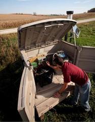
Through the Root
River Field to Stream Partnership state agencies are conducting intensive
surface and groundwater monitoring at multiple scales in order to provide an
assessment of the amount and sources of pollution. The goal is to better
understand how agricultural practices affect the health of local streams and
rivers.
The Partnership is based on a cooperative approach to
engaging farmers and residents in the Root
River watershed. Formed in 2009, it consists of farmers, agricultural
groups, conservation organizations and state agencies. The Partnership selected
three sub-watersheds to represent the three geologic regions of the watershed. Since
2010, sediment, nutrient and hydrologic data have been collected in-stream at
each sub-watershed outlet and at edge-of-field runoff flumes.
Kevin Kuehner, adviser with the Minnesota Dept. of
Agriculture will talk at the Oct. 21 BALMM meeting about current efforts with
this ongoing project that began in 2009.
Now in Phase 2, the Partnership is using the data from Phase
I to work with farmers to build on existing conservation practices, and to
identify which practices are practical, best suited for field conditions, and
have the greatest potential to benefit water quality.
Kevin will share benchmark monitoring results from the past
five years and Donna Rasmussen with the Fillmore SWCD will highlight the
approach taken to enhance conservation planning and delivery during the next
phase of the project.
|

The Minnesota Environmental Quality Board’s Water
Policy Report is organized as a menu of options to move beyond the status
quo on water challenges. It provides a framework to continue a broad
conversation on water policy with local and state implementation partners. The
report includes voluntary and regulatory solutions as well as proposing system
changes that harness market forces and look to change cultural expectations. Finally,
in some areas, more study is needed to best determine how to take action.
Key findings from the report include:
- Minnesota is a global leader in water: Water concerns are a global issue
and Minnesota water technology industries are leading the way in innovations to
clean, reuse, and more efficiently use water for the whole world. This sector
employs more than 13,500 Minnesotans, pays above average wages, and puts
Minnesota in the top 10 in technology export and patents.
- Minnesotans need to protect their waters: Living plant cover and green
infrastructure reduce runoff and increase infiltration on urban and
agricultural lands. These practices hold water on the landscape, filter
contaminants, and reduce runoff.
- Minnesotans need to identify vulnerabilities and increase the resilience
of all communities. Flooding is becoming a reality for more Minnesotans as extreme
rainfall events increase. And while not all parts of the state have water
supply issues, many wells have shown decreased water levels in recent years.
The Environmental
Quality Board is made up of nine Minnesota agency heads and five citizen
members. In addition to other duties, the board provides leadership and
coordination across agencies on priority environmental issues that are
multi-jurisdictional and multi-dimensional, as well as provide opportunities
for public access and engagement.
|
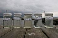
The MPCA is asking
for your data to help assess the condition of lakes and streams and build a
national database of water quality.
The MPCA is
specifically interested in the following priority watersheds because we will be
determining whether these water bodies meet state water quality standards in
early 2016:
- Clearwater River
- East Fork Des Moines
River
- Lower Des Moines
River
- Lower Minnesota River
- Rainy River –
Headwaters
- Red River of the
North – Marsh River
- Upper/Lower Red Lake
- Wild Rice River
The MPCA is also
looking for data on the Minnesota River from the headwaters to the Mississippi
River.
If you have data from
outside a priority watershed or one of these areas, the agency will also accept
it.
The MPCA will use your
data to:
- Help plan for future
monitoring efforts including what to monitor for and where to monitor.
- Identify pollutant “stressors”
that are causing or contributing to problems or threats to fishing, swimming,
and recreational uses.
- Evaluate the success
of ongoing activities to protect and restore water quality.
Deadline: Submit project, lab, and field data now through Nov. 2.
Deadline: By Dec. 15 you will need to review the data
entered by the MPCA.
Find out more on the MPCA's
surface water data website.
Your role in
collecting these data is important to Minnesota’s effort to identify impaired
waters, as well as those waters in need of additional protection. Thank you for
your help.
For more information
on submitting data:
- Nancy Flandrick, 651-757-2361
(St. Paul, Duluth, Rochester, and Mankato regional offices)
- Jean Garvin, 651-757-2378 (Brainerd, Willmar,
Marshall, and Detroit Lakes regional offices)
For more information
about how we use your data to assess lakes and streams see the MPCA’s
water quality assessment website.
|
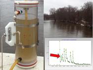 The Request for Proposal (RFP) process for the
Watershed
Pollutant Load Monitoring Network (WPLMN) is now open. Agreements/contracts under this program are financed
through the Minnesota Clean Water Fund as established by the Legacy Amendment.
The MPCA will award up to $1.5 million in two-year terms with
the option to extend an additional two years. All proposals must be submitted through the SWIFT
e-supplier portal and must be received no later than Oct. 13. Proposals received
after this deadline will not be considered. Date is subject to change. Please
check the SWIFT Event for any updates to submittal date.
Proposers must have a SWIFT Vendor ID and
Supplier Portal Account to access the RFP and apply for WPLMN funding. Detailed
registration directions are available on the SWIFT e-supplier portal. Proposers should
be aware that it can take several days to receive a required Vendor ID from
SWIFT. If you need technical assistance for the SWIFT e-supplier portal, please
contact the SWIFT helpdesk line: 651-201-8100, option 1.
The
primary objective of the WPLMN is to obtain spatial and long-term pollutant
load information from Minnesota’s rivers and streams. Eligible entities
include:
- Soil and Water Conservation Districts
- Watershed Districts
- Regional Planning Organizations
- Watershed Management Organizations
- Local government units (LGUs such as
counties, cities, townships, and Lake Improvement Districts)
- Regional governmental groups
- Joint powers boards
- Minnesota colleges and universities
- Nonprofit organizations
- Native American tribal governments
This
RFP seeks local partners to collect water quality data at select sites in the Red
River, Minnesota River, Upper Mississippi River, Rainy River, and Lower
Mississippi River Basins. Water quality samples will be collected across a full
range of flow conditions with the greatest emphasis given to periods of
moderate and high flow.
Additionally,
local partners will use the FLUX32 model to yield estimates of contaminant loading from
within a watershed. All pollutant load estimates will be reviewed by an MPCA
verification team.
Recipients will be notified and required to
submit a detailed work plan and budget.
Please note that the successful execution
of these projects by the start of the monitoring season is dependent on
adhering to this process and timeline. Additionally, recipients will be
required to use SWIFT to review and approve, through electronic signature, the
final agreement or contract and work plan.
|
The 2015 Green Lands Blue Waters
Conference will be held Nov. 3-4 on the third floor of the Coffman Memorial Union
at the Minneapolis-East Bank Campus of the University of Minnesota.
The theme
this year, "Buffers and Bridges, Farms and Cities,” responds to the
growing interest in Continuous Living Cover farming sparked, in part, by Minnesota’s new buffers
law, the Des
Moines Water Works lawsuit, and the larger than expected dead
zone in the Gulf of Mexico this summer.
Conference
speakers include:
- Wes Jackson,
founder and president of The Land Institute
- Joan
Nassauer, professor of Landscape Architecture, School of Natural Resources and
Environment, University of Michigan
- Don Wyse, professor
of Agronomy and leader of the Forever Green Initiative, University of Minnesota
- John Jaschke,
executive director, Minnesota Board of Water and Soil Resources
- Wayne Anderson,
Minnesota Pollution Control Agency and Mississippi River Gulf of Mexico
Nutrient Task Force
- Mark Tomer,
USDA Agricultural Research Service, National Laboratory for Agriculture and the
Environment, Ames, Iowa
- John Baker,
USDA Agricultural Research Service and adjunct professor in the Department of
Soil, Water & Climate at the University of Minnesota
Registration
for the conference, which offers Continuing Education Units, is available online.
|
The U.S.
Environmental Protection Agency recently approved the Total Maximum Daily Load
(TMDL) report for the Mississippi
River-Lake Pepin Watershed.
This watershed
in southeast Minnesota is known for its coldwater streams and trout fishing. It
extends from Red Wing to Lake City and encompasses 205,747 acres (325 square
miles). This watershed is named for Lake Pepin because all the streams drain to
the lake. However, this study excludes Lake Pepin, which is the focus of a separate
project.
The TMDL report
focuses on reducing bacteria in Hay, Bullard, Gilbert, Miller and Wells creeks
in Goodhue and Wabasha counties. Strategies to reduce bacteria levels include
decreasing feedlot runoff, ensuring wastewater treatment, increasing rotational
grazing, managing manure applications to cropland, and increasing conservation
tillage.
|