April is time to influence design of Southwest LRT stations
The public is invited to attend April open houses to learn about Southwest LRT station features and amenities and to provide feedback on station design concepts. They also will learn about the planned operations and maintenance facility, joint development opportunities and identification of historic properties on the proposed route.
The Southwest LRT Project office, with input from staff at each corridor city, is suggesting which of the four designs ranging from bold to understated would be best suited for each station.
After a brief presentation on station design, project staff will answer questions and receive public input at each of the five open houses.
For those who cannot attend, meeting materials and a comment form will be available online at www.swlrt.org under Public Involvement.
Anyone who needs assistance to participate in the open houses should contact Dan Pfeiffer, Southwest LRT assistant public involvement manager, at least seven days in advance by phone at 612-373-3897 or by email at: Daniel.Pfeiffer@metrotransit.org.
Station Design Open House Schedule
Minneapolis Stations
Thurs. April 2, 2015, 5:30–7:30 p.m.
Wed. April 8, 2015, 7:30–9:30 a.m.
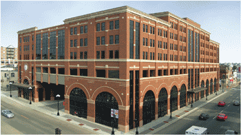
Dunwoody College of Technology
818 Dunwoody Blvd., Minneapolis
Map: https://goo.gl/maps/Vhs71
St. Louis Park Stations
Wed. April 8, 2015, 5:30–7:30 p.m.
St. Louis Park City Hall
5005 Minnetonka Blvd., St. Louis Park
Map: https://goo.gl/maps/j64JQ
Eden Prairie Stations
Thurs. April 9, 2015, 5:30–7:30 p.m.
Eden Prairie City Center
8080 Mitchell Road, Eden Prairie
Map: https://goo.gl/maps/w0rJX
Hopkins & Minnetonka stations
Tues. April 14, 2015, 5:30–7:30 p.m.
Hopkins City Hall
1010 First Street South, Hopkins
Map: https://goo.gl/maps/XdxGq
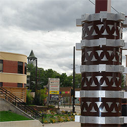 Public input begins this spring for integrating public art into station design
Right: Art at the Prospect Park Station on the METRO Green Line highlights the iconic “witch’s hat” tower visible in the background in nearby Prospect Park.
Integrating public art into station design reflects the history and values of the surrounding community, and enhances the unique identity of each station area. Art can also help passengers navigate the station area. Finally, attractive public art promotes transit use and community pride.
Six to eight artists will be selected to work with the public to design art. Beginning in spring 2015, station art committees and the public will provide input on the integrated public art.
Artist designs will be incorporated into all 17 stations and the operations and maintenance facility. Art will be fabricated and installed during construction of the Southwest LRT line.
|
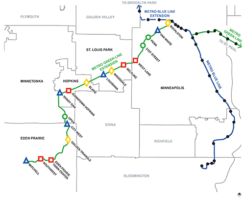
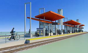
Four distinct station types fit into a variety of settings
Staff considered each station site’s character and previous public input to make the suggestions for station types. Station sites range from residential neighborhoods to commercial areas and major regional employment centers.
The map below shows which type of station is proposed for each station site. Descriptions of the station types, from understated to bolder, and each station area along the line follow.
 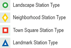 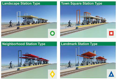
 The Landscape Station Type
Located within a natural setting or a gateway to significant natural features, this understated design is sensitive to its context and engages with natural and recreational features.
Opus Station Located within the Opus office park, which is characterized by a mix of manicured and naturalistic landscapes interwoven with public trail system connections. A park-and-ride lot with 100 stalls and bus connections on Bren Road West are proposed.
21st Street Station Located adjacent to the Kenilworth Trail, in a neighborhood with single-family homes. Bus connections are proposed adjacent to the station. Station access improvements are planned.
Penn Station Located within a valley with open prairie landscape and adjacent the Cedar Lake and Kenilworth trails. Proposed are a pedestrian bridge, elevator and stairs to access the station from Penn Ave. and the Bryn Mawr neighborhood and a bridge connection from the North Cedar Lake Trail to the Cedar Lake LRT Regional Trail. Station access improvements are planned.
|
 The Neighborhood Station Type
Located within a neighborhood or an urban village setting, this design is sensitive to the pedestrian scale of the surrounding area and engages with neighborhood features.
Golden Triangle Station Located in an established industrial/technology park and adjacent a wetland. A park-and-ride lot with 270 stalls and SouthWest Transit bus connections on West 70th Street are proposed.
Blake Station Located at Blake Road south of the Cedar Lake LRT Regional Trail, north of the Blake School and near multi-family and commercial development. A 340 stall park-and-ride structure and adjacent bus connections are proposed. This site is an opportunity for joint development.
Wooddale Station Located at Wooddale Avenue south of Cedar Lake LRT Regional Trail, near newer mixed-used development and established neighborhoods. Bus connections on 36th Street at Yosemite Street are proposed.
Royalston Station Located on Royalston Avenue between Target Field and the Minneapolis Farmers Market, near the North Loop neighborhood and downtown activities. Bus connections are proposed at Seventh St./Olson Memorial Highway and Fifth Ave. and also at Royalston Ave./12th St. and Glenwood Ave. Station access improvements are planned.
|
 The Town Square Station Type
Located at the gateway to a major activity center, the Town Square design is recognizable as a significant place in the community and enhances public spaces.
Southwest Station This multimodal transit hub will be shared between Southwest LRT and SouthWest Transit buses and is located adjacent multi-family, retail and corporate development and Purgatory Creek Community Park. The project plans to add 450 stalls to the existing 924-stall park-and-ride structure.
Town Center Station Located within Eden Prairie’s Town Center, near Lake Idlewild, a private park, retail and multi-family buildings. A roadway to the station from Eden Road is planned. A future Main Street is planned by others adjacent the station. Potential exists for a park-and-ride lot with 160 stalls at this location.
Downtown Hopkins Station Located just south of Excelsior Blvd. and Minnesota River Bluffs LRT Regional Trail, within walking distance to Mainstreet via the Eighth Avenue Artery. A plaza and bus connections are proposed at this location.
Beltline Station Located at Beltline Blvd., south of Cedar Lake LRT Regional Trail, north of Bass Lake Preserve and near multi-family, commercial and industrial uses. A park-and-ride lot with 540 stalls and adjacent bus connections are proposed. This site is an opportunity for joint development.
West Lake Station Located parallel to Cedar Lake LRT Regional Trail, below the West Lake Street Bridge and near dense multi-family and commercial areas. Proposed elevators and stairs will provide station access from the bridge. Bus connections on new West 31st Street (between Chowen and Abbott avenues) and the West Lake Street Bridge are proposed. Station access improvements are planned.
|
 The Landmark Station Type
Located near an institution, community amenity or major employment area, this design enhances station visibility and is recognizable as a significant destination.
Mitchell Station Located on Technology Drive at Eden Prairie’s City Center, adjacent a low-rise corporate campus at the line’s western end. Surrounded by rolling topography, prairie vegetation and wetlands. A park-and-ride structure with 900 stalls for transit use is proposed at this location.
City West Station Located on the edge of Optum and UnitedHealth Group’s corporate campus and at the end of West 62nd Street This station will be visible from Highway 62. A park-and-ride lot with 160 stalls is proposed at this location.
Shady Oak Station Located within a former industrial parcel south of Excelsior Blvd., adjacent to a regional trail, and north of the line’s proposed operations and maintenance facility. A park-and-ride lot with 450 stalls is proposed at this location. Designers propose extending 17th Avenue from Excelsior Boulevard to the station. Others plan a future extension of 17th Avenue to connect the station area to KTel Drive to the south.
Louisiana Station Located at the base of a berm on Oxford Street, just east of the Louisiana Avenue, south of Cedar Lake LRT Regional Trail, and north of Park Nicollet Methodist Hospital. A park-and-ride lot with 230 stalls and bus connections at the Louisiana and Oxford intersection are proposed.
Van White Station Located below Van White Bridge and adjacent to parks, trails and industrial activities. A proposed elevator and stairs will provide access from the bridge. Bus connections are proposed adjacent the station. Planned station access improvements include a new trail bridge over light rail and freight rail to Bryn Mawr Meadows Park.
|
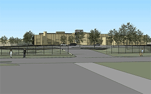 Operation and maintenance facility in Hopkins will support up to 36 light rail vehicles
Left: An artist's rendering showing a street-level view of the entrance to the proposed facility.
The Southwest LRT’s operations and maintenance facility proposed to be built in Hopkins adjacent to the line will provide indoor storage for up to 36 light rail vehicles.
In addition to enclosed storage of light rail vehicles, the building’s approximately 172,000 square feet of space will provide room for about 160 permanent staff to clean the trains inside and out daily, perform routine maintenance and carry out administrative duties.
At Fifth Street South and 16th Avenue South, the location is midway on the alignment for operational efficiency. The operations and maintenance facility also provides an opportunity to incorporate public art.
|
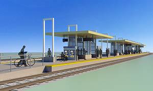
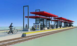
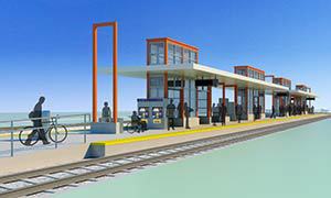
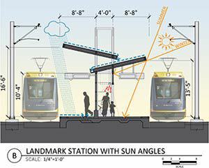
Station design goals: comfort, sustainability, accessibility, safety
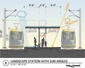 Architects and designers at the Southwest LRT Project are considering wind and weather as well as passenger feedback on the METRO Blue and Green Lines to create safe and comfortable stations.
For example, the illustrations at right show how different station canopy designs shelter customers from sun and rain.
Stations will have enclosures to shelter passengers from wind and typical Minnesota weather with on-demand controlled heaters. Station canopies will be designed to direct water away from the platform edges. A roof drain system will capture water, which will flow into downspouts and away from the station.
|
 For sustainability, designers will select durable, long lasting and low-maintenance construction materials, energy-efficient lights that minimize light pollution and apply best-management practices to address stormwater runoff.
Station platforms will be designed to meet accessibility requirements and provide spaces that are safe, comfortable and allow passengers to move freely. Station platforms will have a balance of benches and leaning rails to meet passenger needs.
For safety, designers will minimize the use of solid walls to provide clear views to and from the platform and will include safe illumination levels and multiple security cameras. To discourage passengers from walking in the guideway, designs will include detectable warnings, guardrails, signage and fencing.
|
Blake, Beltline stations under consideration for joint development
 Joint development involves a transit facility combined with private development that includes housing, offices or retail.
Right: Grand River Station in La Crosse, Wisconsin, combines a bus facility with public parking, retail, housing and offices.
Planners are eyeing opportunities for joint development where park-and-ride facilities are planned at two Southwest LRT stations, Blake Station in Hopkins and Beltline Station in St. Louis Park.
The Federal Transit Administration encourages joint development projects because they promote efficient land use and increase ridership and connections to jobs. The projects can also help increase the local tax base. At the two locations identified, they would improve the line’s integration with the surrounding neighborhoods.
The joint development process would start with the Metropolitan Council acquiring land for the park-and-ride facilities at Blake and Beltline. In partnership with the cities of Hopkins and St. Louis Park, a private developer would be selected to design and construct the private portion of the joint development.
The Metropolitan Council would own the land where the development occurs. Money would come back to the Council through a long-term ground or air-rights lease, or an easement. That money can then be used to offset operations and maintenance costs.
The Metropolitan Council, Hennepin County and the cities will work together to assess what type of development would be most successful at those sites. That assessment will involve working with consultants on a detailed market and financial feasibility analysis, and will produce preliminary designs of how the private development would work best with the proposed park-and-ride facility.
The consultants are expected to be hired in coming months and complete their work by the end of this year.
The joint development process is in its early stages at the two stations, needs approval from the FTA and the cities and requires a willing private sector property seller and developer. The transit parking project at the site would still proceed as planned if private partners do not come forward.
|
Southwest LRT route rich in historic buildings and districts
The route has seven historic districts, 11 buildings and structures listed on or eligible for the National Register of Historic Places
Seven historic districts and 11 buildings and structures on the planned Southwest LRT route are identified to date as being on the National Register of Historic Places or eligible for it.
Southwest LRT Project and Minnesota Department of Transportation staffers, in coordination with the Federal Transit Administration, are reviewing potential effects of the LRT project on those significant properties as required by the National Historic Preservation Act of 1966. Project staff will attend the station open houses in April to answer questions about the historic properties.
They will also be identifying measures to avoid, minimize or mitigate any adverse effects on historic properties as part of the ongoing process. These measures will be included in an agreement between the Federal Transit Administration, Minnesota State Historic Preservation Office, U.S. Army Corps of Engineers and other consulting parties.
The properties identified to date include Minneapolis’ Kenwood and Lake of the Isles residential historic districts, an experimental grain elevator in St. Louis Park and a railroad depot on Excelsior Boulevard in Hopkins.
Several Minneapolis properties have been identified as eligible for listing due to their type, period or method of construction and artistic value. They include the Minikahda Club, Dunwoody Institute and several private homes. Other historic districts also include part of downtown Hopkins, two railroad lines and the Grand Rounds park system in Minneapolis.
To be eligible for listing on the Register, a property must generally be at least 50 years old and retain sufficient integrity to convey its significance. The property must also meet one of four criteria:
- Association with events, activities or broad patterns of history
- Association with persons significant in the past
- Characteristics of a type, period of method of construction with high artistic value
- Potential to yield information
Historic properties and districts by city
Minneapolis
- Minikahda Club, 3205 Excelsior Blvd.
- Four private homes
- Dunwoody College of Technology, 818 Dunwoody Blvd.
- Grand Rounds Historic District
- Kenwood Parkway Residential Historic District
- Lake of the Isles Residential Historic District
- Minneapolis Warehouse Historic District
-
St. Paul, Minneapolis & Manitoba Railroad/Great Northern Railway Historic District
-
Osseo Branch of the St. Paul, Minneapolis & Manitoba Railroad Historic District
St. Louis Park
-
Chicago, Milwaukee & St. Paul Railroad Depot, 6210 W. 37th St.
- Peavey-Haglin Experimental Concrete Grain Elevator (with the Nordic Ware logo), Highways 100 & 25
- Hoffman Callan Building, 3907 Highway 7
Hopkins
-
Hopkins Commercial Historic District, Mainstreet, Eighth to 11th Avenue
- Hopkins City Hall, 1010 First St. South
- Minneapolis & St. Louis Railroad Depot (also known as The Depot coffeehouse), 9451 Excelsior Blvd.
About the Project:
The planned Southwest Light Rail Transit (LRT) Project (METRO Green Line Extension) will operate from downtown Minneapolis through the communities of St. Louis Park, Hopkins, Minnetonka, and Eden Prairie, passing in close proximity to the city of Edina. The line will connect major activity centers in the region including downtown Minneapolis, the Opus/Golden Triangle employment area in Minnetonka and Eden Prairie, Methodist Hospital in St. Louis Park, downtown Hopkins, the Eden Prairie Center Mall, and the Minneapolis Chain of Lakes. Ridership in 2030 is projected at nearly 34,000 weekday boardings. The project will interline with the METRO Green Line, which will provide a one-seat ride to destinations such as the University of Minnesota, state Capitol and downtown St. Paul. It will be part of an integrated system of transitways, including connections to the METRO Blue Line, the proposed METRO Blue Line Extension, the Northstar Commuter Rail line, a variety of major bus routes along the alignment, and proposed future transitway and rail lines. The Metropolitan Council will be the grantee of federal funds. The regional government agency is charged with building the line in partnership with the Minnesota Department of Transportation. The Southwest Corridor Management Committee, which includes commissioners from Hennepin County and the mayors of Minneapolis, St. Louis Park, Edina, Hopkins, Minnetonka, and Eden Prairie provides advice and oversight. Funding is provided by the Federal Transit Administration, Counties Transit Improvement Board (CTIB), state of Minnesota and Hennepin County Regional Railroad Authority (HCRRA). The Southwest LRT Project website is www.swlrt.org
|