The METRO Blue Line Extension is beginning work on a Supplemental Environmental Impact Statement (EIS). In 2016, the Metropolitan Council published a Final Environmental Impact Statement and Determination of Adequacy, based on the preferred project route at that time. Since then the project has pivoted away from portions of the original route requiring this supplemental EIS.
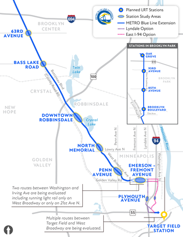
The route modification process was documented in a draft report, available for public review and comment, and a final report published in April 2022. In June 2022, the Metropolitan Council and Hennepin County identified the final recommended route to advance in design and environmental review.
The Supplemental EIS will focus on potentially significant changes to the project based on the identification of the METRO Blue Line Extension recommended route. The full range of environmental, social, and economic impacts will be evaluated as was presented in the Final EIS. A draft of the Supplemental EIS is expected in the fall or early winter of 2023, with the Supplemental Final EIS anticipated in 2024.
The scope of the METRO Blue Line Extension Supplemental EIS is available to view on the projects website.
The public is encouraged to comment on the scope of the Supplemental EIS through November 7, 2022 and can do so in the following ways:
- Visit bluelineext.org and leave an online comment
- E-mail Environmental Compliance Lead Neha Damle at neha.damle@metrotransit.org
-
U.S. Mail: Ms. Neha Damle
Environmental Lead
Blue Line Extension Project Office
6465 Wayzata Boulevard, Suite 500
St. Louis Park, MN 55426
|
As planning and environmental work continues on the METRO Blue Line Extension Project, you may notice project staff in your neighborhood performing field work. Work you may see includes:
Surveying
Surveying determines the elevation of land and the location of features such as trails, roads, walls, existing railroad tracks, overhead utility lines and other structures, as well as property lines. Surveying will be performed along the entire route of the METRO Blue Line Extension. Surveying crews typically consist of two surveyors: one with a tripod-mounted recording tool and another with a vertical survey rod; surveyors also use Global Positioning System (GPS) equipment.
Wetland Surveying
Survey crews also check the location of wetlands that may be affected by the METRO Blue Line Extension project, in order to avoid, minimize or mitigate the impacts of construction on the region's valuable wetland resources.
Noise and Vibration
Crews will be using specialized recording to equipment to measure ambient sound along the METRO Blue Line Extension route. Crews will also be using special equipment to measure vibration.
Cultural Resources Investigations
Cultural resources studies are needed to determine if there are historic properties, those eligible for or listed in the National Register of Historic Places, that may be affected by the METRO Blue Line Extension project. Field survey of historical architectural properties will include documenting buildings and structures (primarily from public right-of-way) with photography. This documentation will inform analysis to determine their National Register eligibility.
Archaeological investigation may be required in specific areas where there is potential for archaeological resources. Hand tools, machinery, or other remote sensing devices to conduct subsurface testing (i.e., shovel testing) will be used to locate subsurface features. Limited excavations may also be required to determine horizontal and vertical boundaries.
Follow us on social media
Get the latest METRO Blue Line Extension updates by following us on:
Sign up for project updates to get the latest information
If you were forwarded this e-newsletter and want to receive this information directly, sign up to receive METRO Blue Line Extension project updates at BlueLineExt.org.
|