|
New Online Tool Helps Farmers,
Applicators Time Manure Applications with Weather
St. Paul, MN: The
Minnesota Department of Agriculture (MDA) has teamed up with the National
Weather Service to design a tool that helps farmers and commercial applicators
determine the best time to apply manure.
The Runoff Risk
Advisory Forecast tool uses past and predicted National Weather Service weather
data like precipitation, temperature, and snow melt. It predicts
the likelihood that applied manure will run off fields in daily, next day, and
72 hour increments. Farmers and commercial applicators use an interactive map
to locate their field and find the forecasted risk. Users can also sign
up for email or text messages for their county that alert them to a severe runoff
risk for that day.
“By providing this information, we hope to give our farmers
and commercial manure applicators the tools they need to make well-informed
decisions,” said Agriculture Commissioner Dave Frederickson. “By being able to
better predict times of high runoff risk, we can decrease the potential loss of
manure to our waterways and increase farm productivity by saving nutrients on
the land. It is a win-win situation based on an easy-to-use tool."
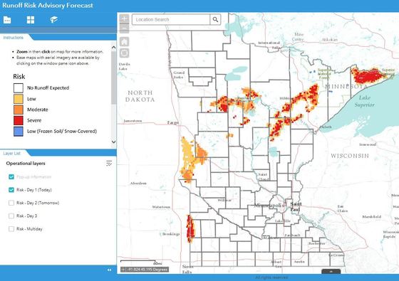 Yellow, orange, and red patches on this map indicate a risk for runoff in this screenshot of the Runoff Risk Advisory Forecast.
When someone goes to the interactive map, the runoff risk is
displayed in one of four categories: no runoff expected, low, moderate, and severe.
When the risk is moderate or severe, it is recommended that the applicator
evaluate the situation to determine if there are other locations or later dates
when the manure application could take place.
The forecasting tool can also be used by others looking for
climate information including 2” soil depth temperatures which are useful at
planting time, and 6” soil depth temperatures which are helpful when
determining fall fertilizer application in appropriate areas.
The Minnesota Runoff Risk Advisory Forecast is part of a
larger federal project. The National Weather Service has provided data and
guidance to states to create similar tools in Michigan, Ohio, and Wisconsin. State
funding for the project was provided by the Clean Water, Land, and Legacy
Amendment.
###
Having trouble viewing this email? View it as a Web page.
|