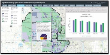
 Hennepin County is diverse, and demographic characteristics vary across the county. Human Services and Public Health (HSPHD) GIS staff are in the process of creating a series of story maps to explore these demographic patterns. These story maps include a narrative, interactive maps, charts and other graphics and the story map viewer can click on the map to view pop-ups containing detailed data. While the story maps are focused on looking at differences across the six HSPHD service delivery regions, data are presented for the whole county and in some cases, comparisons are made across all of the counties of Minnesota.
|
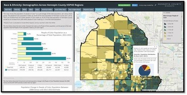 Currently there are two story maps available to view – one is focused on race and ethnicity patterns, and another focused on age and sex population structure. Future story maps will highlight patterns in housing and household relationships, and income and poverty. Additionally, another story map will be created focusing on HSPHD clients (generalized to protect data privacy) to explore how our client population varies across the service delivery regions. These story maps act as a demographic atlas and resource for all Hennepin County employees to learn more about the demographic makeup of our county.
|
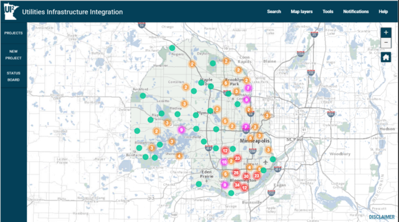
The Utility Infrastructure Integration (UI2) solution is an online project collaboration tool incorporating a web-based interactive mapping application. UI2 enables government agency and utility company partners to visualize project locations and share information about major construction projects. Accessible only by participating agencies and utility companies, this tool greatly enhances the ability of all parties to coordinate programming and construction efforts.
UI2 successfully:
- Improves collaboration between utility partners and managers of the public right-of-way by improving communications, developing relationships and educating partners.
- Improves efficiencies of construction events and lessens their overall impact on the transportation network and the traveling public.
Ultimately, some of the overall benefits accrued as a result of the project include:
- Less disturbance of public right-of-ways and disruptions to local residents and businesses
- Less frequent redirection of traffic flow and the transportation network
- Increased project cost savings from sharing construction costs and eliminating utility cuts to new roadways
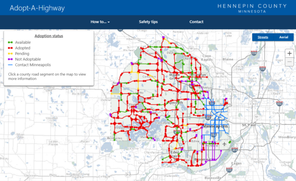
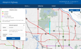
The Public Works Transportation
Operations department and the GIS Office have implemented a smartphone friendly
interactive mapping solution that allows Adopt-a-Highway volunteers to check
for available road segments, sign up to adopt segments, and report back
clean-up activities. This application responds to a request from residents and
organizations to streamline the process and make it mobile friendly.
- Improve
communication between county and Adopt-a-Highway volunteers and organizations
- Improve
the ability of Adopt-a-Highway volunteers to easily notify the county of
clean-up activities
- Streamline
reporting, notification, and work order management related to Adopt –a-Highway
activities and pick-ups within Public Works
- Increase
Adopt-a-Highway participation
- Improve
visibility of Adopt-a-Highway program and promote county volunteer
opportunities
|
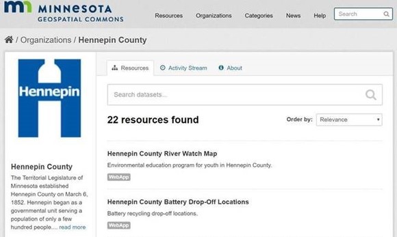
Hennepin County is now publishing content on the Minnesota Geospatial Commons. The Minnesota Geospatial Commons is a collaborative website where organizations across the state publish free and publicly available geospatial “resources,” i.e. geospatial data, maps and applications. Many of Hennepin County’s GIS applications can be found on the Commons, as well as a link to the county’s Open Data page. Hennepin County will continue to publish additional resources over time. Use the Geospatial Commons for accessing Hennepin County’s GIS resources, as well as for many other organizations that are actively publishing their resources to the Commons!
|