GIS maps redesigned for mobile!

GIS notes banner


Redesigned Interactive Maps

Three of our most popular web applications have been updated with new features and redesigned to be easier to use and mobile friendly.


Property Map V2

 Property Interactive Map highlights include:

  • Historical aerial imagery from 2000 through 2015 
  • The ability to add markup and text to the map
  • Create print-quality PDF’s of the image on the screen


Natural Resources Map

 Natural Resource Interactive Map highlights include:

  • Same features listed above
  • Additional layers including emerald ash borer infested sites and conservation easement boundaries
  • More links to natural resources information


ParksInteractiveMap

Parks Interactive Map highlights include:

  • Bikeways and transit stops added
  • Can view at once all parks that have selected amenities
  • Improved search capabilities

Geo:Code 2.0 Event - March 5th & 6th

geocode

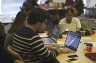
This free weekend event will connect civically-minded community members with geographers and technology experts to collaborate on the use of technology and data to solve community problems or make government easier to use. Work on an open source project, take a run at visualizing available open data, help out with some research, work collaboratively with local government staff to improve public services or just generally put your shoulder into projects centered on improving, enjoying or exploring the places we live in the Twin Cities. 


Bring your passion to make our community and government better. We’re calling people of all backgrounds and skills. Citizens, designers, developers,  mappers, students - no technology experience needed. Everyone and every idea is welcome!


For details and registration, visit www.hennepin.us/geocode.


Hennepin County GIS Open Data

OpenData

Hennepin County has expanded access to its collection of public geographic information systems data, which is used by the public and businesses for a variety of needs. This data is available to the public free of charge and without a need for a license.


Highlights of open data include:

  • Hennepin County Parcels
  • Hennepin County Bikeway System
  • Hennepin County Parks
  • Wetland Inventory
  • Voting Precincts
  • And many more!!

Please visit the Hennepin County GIS Open Data Site to learn more.