District news
How MnDOT’s Photogrammetry & Remote Sensing Unit Supports GIS
By Sandra Flores Castillo
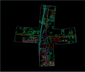
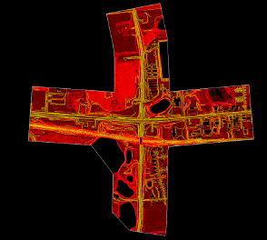
At the Minnesota Department of Transportation (MnDOT), the Photogrammetry & Remote Sensing Unit delivers the high-accuracy mapping products that engineers, planners, and GIS professionals rely on every day. Using aerial imagery, drones, LiDAR, and advanced 3D stereo workstations, our team creates the foundational datasets that support transportation projects across the state.
Core Mapping Products: PLAN & DTM:
Before any Planimetric mapping begins, we first collect aerial data using drones or airplanes equipped with high resolution specialized cameras and LiDAR sensors. This imagery and LiDAR data are then processed through the Aerial Triangulation (AT) workfl ow, where we “tie” the overlapping images together and align them using ground control points and fl ight data. This step ensures all photos are accurately positioned in 3D space. Once the AT meets required accuracy standards, the imagery is ready for precise planimetric/topographic feature extraction.
As a Photogrammetric Technician, I focus on two primary mapping products:
● Planimetric (PLAN) – 2D feature layers such as road edges, sidewalks, buildings, utilities, hydrology, and vegetation. These are extracted through 3D photogrammetry and become GIS-ready layers used for asset mapping, planning, and basemap updates.
● Digital Terrain Models (DTM) – A detailed representation of the ground surface built from breaklines, spot elevations, and void areas. DTMs support roadway design, drainage analysis, 3D visualization, and GIS elevation products like contours and hillshades.
Unitwide Work That Enhances GIS
Our team also provides vital geospatial services, including:
● UAS (drone) mapping for bridges, construction, emergency response, and small-area projects.
● LiDAR acquisition and processing for terrain modeling, hydrology, and vegetation mapping.
● Orthophotography production that serves as statewide GIS basemap imagery.
Connecting Photogrammetry to GIS
Photogrammetry delivers the source data (geometry, elevation, imagery) while GIS transforms it into analysis, applications, and decision-making tools. Together, they form the backbone of Minnesota’s transportation mapping, supporting safer roads, stronger infrastructure, and better public access to reliable geospatial information.
 |

Mapping Momentum: A Message from MnDOT’s GIS Program Manager
By Amy Harrigan (she/her)
After six months as MnDOT’s Transportation Data & Analysis Program Manager, I’m excited to share a few reflections and updates as we continue building momentum across our statewide GIS efforts.
Many of you already know me through meetings, collaborations, or shared projects—and I’ve appreciated every chance to learn from your expertise and see the incredible work happening across the agency. With over a decade in GIS, spanning consulting, utilities, and state government, I’ve seen how spatial data drives smarter decisions, fosters collaboration, and improves public service. That belief is what led me to MnDOT, and it continues to guide how I show up every day.
In this role, I lead the Transportation Data & Analysis section within the Office of Transportation System Management. My team supports statewide mapping, roadway data, the Linear Referencing System (LRS), traffic monitoring and forecasting, and GIS services—ensuring MnDOT and its partners have timely, reliable data to plan, operate, and improve Minnesota’s transportation system. These resources are essential for federal reporting, investment decisions, and public transparency.
Beyond operations, I provide strategic leadership for MnDOT’s GIS initiatives—co-chairing the GIS Steering Committee and participating in the MN Geospatial Advisory Committee to align our spatial products with agency goals. Whether supporting transportation studies or modernizing our mapping infrastructure, I’m focused on building a data-driven foundation that helps MnDOT deliver safe, equitable, and forward-thinking solutions.
As I settle into this role, my focus is on listening, learning, and laying the groundwork for innovation. I see GIS as a bridge between data and action—helping us visualize challenges, communicate solutions, and drive progress. I’m passionate about expanding its use across MnDOT and advocating for the end-users who make it all work.
Looking ahead, I’m excited about the possibilities—from new mapping tools and smarter data workflows to more inclusive spatial solutions. As we build out the Transportation Data & Analysis (TDA) program, my vision is to strengthen our strategic impact while continuing to deliver the core services our partners rely on. That means investing in foundational excellence—ensuring our data remains accurate, timely, and accessible—while identifying opportunities to align our work more closely with MnDOT’s long-term goals.
One of my priorities is helping TDA become a more proactive partner in agency-wide planning and policy. That includes clarifying program priorities, enhancing cross-team collaboration, and creating more space for innovation. I want our team to feel empowered not just to maintain systems, but to shape them—bringing ideas forward, experimenting with new tools, and helping MnDOT make smarter, spatially-informed decisions.
I also believe MnDOT is just beginning to tap into the full potential of GIS. From corridor studies to equity analysis, spatial data can reveal patterns and possibilities that traditional formats often miss. I’ll be working to expand GIS literacy across the agency, support more integrated workflows, and ensure our spatial products are not only technically sound, but also intuitive, inclusive, and impactful.
Thank you for the warm welcome and continued collaboration. I’m always happy to connect—whether it’s to talk strategy, data, or just swap map stories.
|

Vision for the GIS Steering Committee
By Darren Laesch
The GIS Steering Committee and its associated workgroups, developed through the original Strategic Plan, have contributed significantly to our success. GIS professionals are now embedded in offices and districts throughout MnDOT. We’ve established onboarding tools, a training curriculum, standards, and networking opportunities. Many data silos have been retired, and we continue to improve the quality and accessibility of our data. Committee members are innovative, quick to adopt new technologies, and responsive to evolving needs—such as field collection applications and public GIS application administration.
My vision for the GIS Steering Committee is to build upon these successes, empower our GIS professionals to lead, and expand agency-wide awareness of GIS. The original Strategic Plan gave us the structure to establish a strong foundation of quality data, consistent practices, and highly skilled professionals. To continue maturing as an organization, we must become more focused and unified in our priorities.
My expectations for the GIS Steering Committee Voting Body are to:
- Focus our efforts and establish clear priorities,
- Strategically utilize workgroups to develop solutions, and
- Implement recommendations across the agency.
For this to be successful, Steering Committee members must take active leadership roles within workgroups. I also see a need to expand our membership to include more supervisors, managers, and leaders to help implement meaningful change throughout the agency.
I’m grateful for the opportunity to work with such passionate and talented individuals in the GIS community. Leading this group has been a truly rewarding experience.
|
 |
|
Minnesota GIS contacts
Minnesota County GIS contact information: https://www.mngeo.state.mn.us/county_contacts.html
Minnesota City GIS contact information: https://www.mngeo.state.mn.us/city_contacts.html
Minnesota Tribal Government GIS contact information: https://www.mngeo.state.mn.us/tribal_GIS_contacts.html
|
Trivia
1. Name the best Lakes for Ice fishing in Minnesota.
2. Guess the dates of the top three Snowfalls for the Twin Cities:
3. Where and when was the largest recorded single snowfall in Minnesota history?
GIS Bytes
GIS Bytes webinar: Incorporating GIS in Minnesota Air Quality Alerts and Forecasts
Thursday, December 11, 12 p.m. - 1 p.m.
|
The Minnesota Pollution Control Agency (MPCA) issues air quality alerts and forecast information for the entire state of Minnesota. Beginning in 2018, MPCA continues to modernize the air quality forecast program. This has resulted in new geospatial tools for the display of air quality data and the dissemination of air quality alerts. Further research is now focused on how the forecast and alert process can be improved using GIS tools. This presentation will explore some of the technical tools and methodologies being implemented as well as a look at what new changes which are in development.
Presenter:
-
Matt Taraldsen is the Supervisory Meteorologist of the Risk Evaluation and Air Modeling unit at MPCA. He's been at MPCA for four years, two as an air quality forecaster/meteorologist, and two as supervisor. Before "moving to the business" he spent two years at MNIT partnering at MPCA as a Spatial Data Manager. Before becoming institutionalized at the state, he worked as a Solutions Engineer at Esri and as an Instructor at the National Weather Service Warning Decision Training Division in Norman, Oklahoma. He has a Master's in GIS from the University of Minnesota and a B.S. in Meteorology from Saint Cloud State.
Download the GIS in Air Quality Alerts and Forecasts meeting invitation
|
Access GIS Bytes
Issues accessing a GIS Bytes meeting invitation? See the meeting invitation help page.
Questions about a session? Contact Kristina Krepela, Chair of the GIS Bytes Workgroup.
Missed a GIS Bytes? Find recordings of past presentations on the All Things Geospatial Viva Engage community page.
Interested in content applicable to the wider geospatial community? Subscribe to Minnesota GIS News!

The Results are in - 2025 MnDOT GIS Survey
By Ben West
Thank you to all the people who took the 2025 MnDOT GIS survey. The survey was developed by a small group of office, District, and MNIT@DOT staff, with additional feedback from the MnDOT GIS workgroups. This expanded focus resulted in a broader range of topics and a better response rate, with 141 staff submitting responses.
The survey questions can be broken into 8 broad categories. Each category provides helpful insights into who our GIS users are, how they use GIS software and data, what their struggles are, and how they feel about the MnDOT GIS community.
Question Group: GIS Background
Our GIS users have mostly migrated over to ArcGIS Pro as their primary desktop GIS platform and make use of online resources such as Georilla and the MnDOT GIS Portal. They have diverse backgrounds for how they obtained their GIS experience (from on-the-job training to formal degrees), with many reporting 10+ years of GIS use. The survey shows they apply GIS to a broad suite of tasks; this includes data analysis, map creation, asset management, and use of GIS to support decision-making.
Question Group: General Spatial Data
Most respondents were confident in their ability to more generally find the spatial data they need and commonly listed struggles with data as: right-of-way and utility data, cultural and environmental datasets, speed limits, stormwater and drainage infrastructure, and metadata and authoritative sources. Users are broadly aware of the common data repositories (GDRS, Minnesota Geospatial Commons, MnDOT GIS Portal, etc.) to locate data. However, a number of them expressed a need for a centralized data hub or improved search tool to reduce time spent looking for datasets across multiple platforms.
Question Group: Asset Spatial Data
The Asset data responses have many similarities with the General Spatial Data section. Most respondents were confident in their ability to find the asset information they need. A particular emphasis was made about the need for right-of-way boundaries, utility locations, inspection records, and stormwater/ditch/wetland data. Some users noted they have access to data but don’t know where to find it, while others mentioned incomplete or outdated datasets.
Question Group: LRS Spatial Data
Survey takers looked at a variety of data priorities. By a significant margin they ranked accurate reliable data as more important over timely real-time data. They similarly prioritize LRS accuracy over rapidly deployed data. Of the different roadway attributes the highest ranked roadway attribute was Centerline Geometry Accuracy; followed by Centerline Background Data and Jurisdictional Information.
Question Group: GIS Help! (General)
A little over half of the survey takers know who to contact when in need of assistance, but there is still a strong percentage who, at times, are unsure who to contact with their questions. They also strongly prefer training in short how to video format, live online training, step-by-step guidance documents, and self-paced courses or e-learning. The topics staff are most interested to learn more about were navigating and using web maps and apps effectively, creating web maps and apps, A.I. and GIS, managing content, and geoprocessing tools and automation.
Question Group: GIS Help! (Technical)
There is separate needs around more technical GIS topics. Survey takers noted they commonly run into ArcGIS Pro speed issues, especially as it relates to network drives and online content. There was also strong interest in Virtual Machines with extra computing power specific for ArcGIS. In general users noted a desire for faster, more stable GIS environments, especially for remote work.
Question Group: GIS Standards
Staff are generally interested to very interested in improved guidelines and standards for many of the GIS operations and GIS content produced at MnDOT. This includes everything from standardized templates for Web Apps to processes like publishing data and sharing between GIS and CAD systems. Another common sentiment was more detailed metadata that helps users clearly define the specific parameters of the data they’re looking at for decision making purposes.
Question Group: GIS Governance
Survey takers have a strong understanding of how GIS excels with making complex data accessible and serves how it can serve as an active tool in the decision-making process. They also understand the role it plays in day-to-day operations with assets, project planning, and scoping. The general consensus is more can be done within the larger GIS operational structure at MnDOT to make the existing Workgroups and Steering Committee more effective to help with guidance, governance, and decision making for the MnDOT GIS community.
Conclusion
These results provide vital guidance and insights on the current status and needs of the GIS community at MnDOT. The results will help directly influence the direction of the GIS workgroups and the various GIS support staff throughout the agency. We are a mature system of support and are doing many things well, but this survey helps identify the areas where growth is still needed.
|
 |
Minnesota Winters: MnDOT keeps the roads safe
MnDOT GIS Newsletter Team
Amy Sanda (Editor) – Research Analysis Spec, OTSM
Bob Wolbeck - RASS, GIM, OTSM
Amy Harrigan, TDA Director, OTSM
Sandra Flores Castillo, Photogrammetry
Darren Laesch, Administrative Senior Engineer
Ben West, MNIT
| Back to top |

|