Project Data Management Section (PDMS) quarterly newsletter

Digital Delivery/BIM

ISO 19650 is an open, international standard for information management and Building Information Modeling (BIM). ISO 19650 outlines a structured approach to streamlining and automating the complex process of delivering construction projects. It applies to both the vertical and horizontal construction industries and spans the full lifecycle of built assets.
The ISO 19650 standard establishes universal best practices for generating, managing, and exchanging project information. With proven benefits like better coordination of project information, collaborative data environments, and reductions in project delivery time and costs, some countries have mandated adoption of international standard. There are national mandates for BIM use on public projects in Finland, Norway, Denmark, Sweden, Singapore, UAE, and the UK. France and Australia are expected to issue national BIM directives in the near future. Mandatory or not, BIM use may occur at different levels. The ISO 19650 framework is flexible and may be applied to the extent that it meets an organization’s needs and confers desired benefits.
The ISO 19650 series is divided into 5 parts published between 2018 – 2022:
|
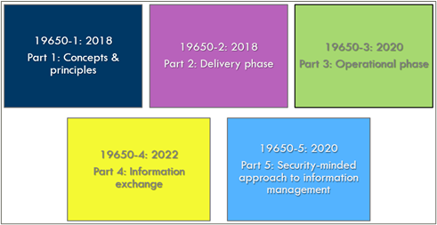 |
Part 1 covers information management terminology and concepts. BIM-specific information deliverables and processes are defined. For example,
Project Information Model (PIM) - The PIM supports delivery of the project and contributes to the Asset Information Model (AIM) to support asset management activities. The PIM contains details of project geometry, location of equipment, performance requirements during project design, method of construction, scheduling, and costing.
Part 2 focuses on project delivery processes like establishing clear information requirements, creating a BIM Execution Plan, and conducting an Information Model Review. It also covers the architecture of a collaborative, connected data environment. Part 3 examines management of information within the context of the operational (asset-level) phase of construction. It outlines a series of steps with specific decision points and required actions. Part 4 discusses data format standards and exchange protocols. Finally, Part 5 addresses security, specifically, managing access rights and ensuring model integrity.
All 5 parts of the ISO 19650 series are available in the MnDOT Library’s main collection. For a succinct overview of the main topics, this ISO 19650 Cheat Sheet is a good resource.
For more information about BIM concepts, visit the PDMS Web site where you can find a complete listing of BIM Standards and other reference and learning resources including a Digital Delivery/BIM Glossary and Bibliography.
Digital Delivery News
2024-25 District Operations Pilot Projects aim to expand use of Digital Delivery and Advanced Construction Technologies
MnDOT is progressing toward a digital project delivery model. Chris Roy, Assistant Division Director for Operations, affirms the imperative to design more projects in 3D, pass usable models out to contractors and inspectors, collect field data electronically, and employ advanced digital construction technologies like e-ticketing. Use of shared 3D models increases agility in the design process. Digital field inspection lessens the risk of errors and reduces the time required for generating payments. And e-ticketing improves safety by eliminating the need for an on-site ticket taker. These projects provide opportunities to understand how MnDOT can reap the benefits of digital delivery.
District goals for expanding MnDOT’s digital delivery capabilities
|
District(s)
|
Digital Delivery/Advanced Digital Construction Goal
|
|
1, 6, 8
|
Using Mobile Inspector software with Trimble GPS rovers for field inspection, then synching data back to AASHTOWare
|
|
2
|
Providing electronic files for horizontal alignment and 3D milled surfaces to be let as contractual
|
|
3, 4
|
Using 3D models to help populate inspection and field material testing forms
|
|
7
|
Providing 3D files--for informational purposes only--to contractor and inspector
|
|
Metro
|
Expanding e-ticketing
|
Quantimate Update
The Quantimate DOT Working Council met in March. Connecticut, Michigan, Minnesota, and Mississippi DOTs presented on their existing quantities workflows from Bentley ORD to AASHTOWare, which reinforced the shared need for the codename_Quantimate collaboration to proceed. Next steps are 1) for Bentley to develop a proposal that captures the participating DOTs’ core requirements, and 2) for the Working Council to create two sub-groups of ORD and AASHTOWare expert users to provide feedback to developer partners and share best practices with the the larger group of users. For more information about this effort, reach out to Todd Bergland in the Engineering Services Division.
 |
|
CADD Team |
GEOPAK Removal
MNIT is actively tracking MnDOT’s process of reducing the number of individuals with GEOPAK installed. MnDOT division leadership (Ops and ESD) in support of MnIT Security leads are seeking to keep the effort a priority until we are down to shared computers only. Latitude is granted to field personal working with GEOPAK data this construction season. Both Design and Construction will need to move all project content over to ORD for future construction seasons of work.
If you had GEOPAK on your computer to complete a project for turn-in this spring 2024 and you have already turned in that project, you must have GEOPAK removed. All post-letting work by a designer should be done on a shared computer.
For designers with a project whose letting date is beyond July 31, 2024, you need to start planning to convert your project files to ORD. The IT-risk level for GEOPAK increases each week. Should it become non-allowed on the network, the only option for GEOPAK could be shared non-networked machines. That would mean no access to: ProjectWise, S:\ drive, internet, or email. Users who are not working on specific projects and using GEOPAK to pull information from old files will need to start the transition to ORD as well. Data can be pulled from old DGNs with ORD and information can also be brought in directly to ORD from GPK files. This type of work will transition to the shared, standalone computers and the software will not remain on an individual's personal computer.
Migrating to ORD sooner is better and gives the team time to solve problems earlier in the process. The PDMS CADD Unit’s General Engineering Consultant (GEC) contract for ORD Support would be an excellent resource for that type of project data migration effort.
CONNECT EDITION (CE) Workspace
With the removal of Bentley V8i GEOPAK software and migration to Bentley CONNECT Edition (CE) software (OpenRoads Designer, OpenBridge Modeler, Bentley View, OpenRoads SignCAD. Etc.) MnDOT is moving into a 3D based design process and helping MNIT retire an aging/risky software. With CE came new CADD standards. These will enable better future graphics exchange with GIS, alignment with industry standards, and the incorporation of data and metadata in the CAD DGN file for more accurate and speedy quantities reporting.
This new workspace and its correct use will establish uniformity in graphical appearance for files and plan sheets. This agency-wide “always the same look” standard is essential as MnDOT moves away from paper/PDF plan sheets and towards delivering the CAD models directly. When electronic files/models are delivered in place of sheets/PDF - they must adhere to agency contract standards, provisions, specifications for digital content. Design staff will need to deliver files that look the same regardless of which District or consultant generates them. When the DGN files are the Model-As-Legal-Document (MALD), they must adhere to the agency standards.
In preparation for the outcome of the multiple-DOT Quantimate project with Bentley and InfoTech (see Digital Program Delivery/BIM above), MnDOT has a new in-house tool for importing project SEQ/Quantities information into the AASHTOWare Project system. This will shorten the input time for CO Pre-Letting while retaining accuracy of imported Pay Items. All MnDOT projects will need to start using ORD Item Types to store agency pay-items to generate the SEQ sheet for this AASHTOWare Pay Items loading. In addition to Pay Items normally associated with graphics (C&G, Paving, etc.), PDMS CADD have built a method for adding traditionally non-graphic Pay Items, like mobilization.
Addressing Change Requests for CONNECT Edition Standards
District and specialty office staff request/advise changes through the Design Users Advisory Group (DAUG) managed by PDMS Dan Harris. Members of that group provide consensus on changes and PDMS guides for technical limitations and to assure adherence to other CADD Standards. Approved changes become available as a revised CADD Data Standard.
ORD Workspace in ProjectWise: Consultant Access
PDMS tested consultants having live access to the MnDOT ORD/CE Workspace from ProjectWise. At this time no further access of this type will be established. A step back is necessary to assess some technical and general conflicts.
Bluebeam Version Upgrade
Install of the Bluebeam software does not automatically grant a license, but you may not need one.
- Licenses are not required for general commenting on sheets/plans in BlueBeam sessions or BlueBeam Projects
- Licenses are required to create BlueBeam sessions or BlueBeam Projects, perform some complex measurement tasks, signing
Help MnDOT use the software cost-effectively:
- Only get a Bluebeam license if you truly need it.
- If you have a Bluebeam license, you can edit PDF files and may not need to have Adobe Professional.
ConceptStation
The initial effort at bringing this software into MnDOT was not a success. There is still a desire to bring it into the planning/scoping process. There is another effort underway to address shortcomings of the previous effort and to create simple agency information or how to use it and how to generate useful output.
See this 5 minute overview video on YouTube : OpenRoads ConceptStation - conceptual design in hours not days! (youtube.com)
MnDOT Sample Plan - Update for ORD based graphic standards
- The current graphic sample plan is based on GEOPAK graphic standards and thus out of date. PDMS Staff are preparing a revised PDF sheets to exhibit the newer ORD based graphic standards.
- PDMS CADD Unit staff will be working with Metro District on their Sample Plan update effort. The goal is a singular Sample Plan to guide internal staff and consultants. One long-term goal is to establish a single DGN dataset as a source for the Sample Plan.
- Create an underlying CADD project file set to demonstrate how files should be named and organized
CADD Workflow and Task Training
- Non-SRC funding approved contract in place to build out ORD workflows and tasks in MnDOT specific documentation
- Assess for gaps in workflow guides and build out content that is missing
- Tune up of existing resources for consistency and clarity.
- MnDOT staff can see existing workflow and task content in ProjectWise at: pw:\\pw8i.ad.dot.state.mn.us:cadp\Documents\TechSheets\ConnectEdition\
 |
|
AASHTOWare Team |
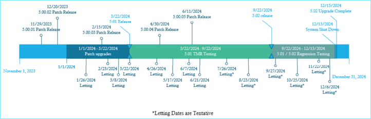
AASHTOWare Project Upgrade Schedule
The next AASHTOWare Project Upgrade will begin in September 2024 with the 5.02 release and move to production with a system shut down between December 13 – December 15, 2024.
 AASHTOWare Project Website
Interested in learning more about AASHTOWare Project? You can visit the AASHTOWare Project Website (APO) at aashtowareproject.org. Found on the public website is information relating to each module, a list of AASHTOWare Project committees and their roles, product sheets, case studies, and a variety of overview videos. For even more information, with approval from the MnDOT End User Designee: Charles Groshens, you may register for APO and gain access to greater detail regarding the maintenance and enhancements for AASHTOWare Project.
Use of Mobile Inspector and Trimble in Digital Inspection
As mentioned in the Digital Delivery section of this newsletter, MnDOT has established the goal of Using Mobile Inspector software with Trimble GPS rovers for field inspection then synching data back to AASHTOWare in many districts. Alan Setrum in District 7 is leading this effort to digitize field inspection. You can learn more about the work being done in this video.
This innovative effort has also gained national attention. The Project Data Management Section hosted colleagues from the Ohio Department of Transportation in a Peer Exchange to discuss the use of Mobile Inspector and Trimble Access in the field. We are so grateful to the project staff of the Minnehaha Avenue Project in Saint Paul for providing a demonstration and allowing our group to ask questions in real time. Also discussed with Ohio DOT was the Quantimate Project to automate pay items from Design to Construction, use of Bentley OpenRoads Designer, MnDOT BIM initiatives, and MnDOT Asset Management.
|
Like what you read?
Sign-up to receive future emails from the Project Data Management Section (PDMS).
|


