District news
District 1: New GIS Coordinator

Q&A With MnDOT’s District 1 GIS Coordinator Charlie Moore
District 1 GIS Coordinator Charlie Moore Started at MnDOT in March 2023. Charlie brings nine years of regional planning GIS experience with him from his previous role serving as ARDC’s GIS Specialist.
What do you do in your role at MnDOT?
I serve as the GIS point-person for District 1 and get to provide GIS/mapping assistance for all areas of the district. I also connect and collaborate with other GIS coordinators in the different districts on GIS-related topics related to transportation and data management. Within these first few months, I’ve been working mostly on preparing construction project maps and GIS data/map requests for the district. I’m looking forward to showcasing more of what capabilities GIS has to offer to assist with district workflows specifically in the areas of web-mapping and online GIS tools.
What do you find interesting about it?
The most interesting thing I find about my role is the variety of work, and also getting to learn more about the future transportation projects, goals, and ideas happening in the region.
What’s your favorite part about what you do?
I’d say my favorite part about what I do is seeing the maps and applications I create be used in real-world situations. GIS is an amazing tool that can be used in all sorts of ways for gathering data, creating maps, and educating people. I’m a visual learner, so I enjoy taking complex information and finding a way to display it in a simple, understandable format that other visual learners can learn from.
Anything else you’d like to add?
I really love the District-1 region. I have lived/worked in this region for over 10 years and am excited to be a part of the talented MnDOT team that gets to support these great communities. Also, I’m new to MnDOT- so if you want to talk maps, trails, skiing, dogs, or anything Northeast Minnesota feel free to reach out!
By Charlie Moore, District 1
District 7 addresses traffic, maintenance and hydraulics concerns
This past December through March, District 7 was receiving many concerns from our external partners, which include both public residents, and county or city officials. These concerns came to the district primarily through emails, Formstack, and phone calls. The type of concerns ranged from potholes needing to be addressed, as well as pavement conditions, and other miscellaneous concerns.
Due to the challenges of the last winter, quite a few comments were being sent to the district. It was then discussed to make a map where these concerns could be tracked (compiled, dated, and addressed). A web map was created, and then a dashboard followed.
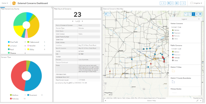 All the concerns are separated by concern type, dated when the concern was issued, noted if they have been addressed, specified if information has been forwarded to the specific individuals needed to address the concern (e.g., maintenance, traffic, hydraulics), noted information from the caller or emailer, whether they had requested District 7 to reach back out to them, and the highway location.
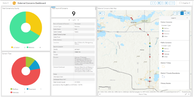
The dashboard has the web map directly tied to it; it is set up as when the data layer is updated, the dashboard reflects the updated change, and when zoomed in closer to a location in the map, the concern counts reflect which concerns are visible in the map extent.
Both the map and dashboard are currently hosted on Portal. District 7 has previously mapped information obtained from plans, studies, and planning outreach efforts but this is the first attempt to actively log publicly sourced comments. It will help shape maintenance response priorities and inform capital improvement project timing.
By Angelica Tejada, District 7
MnDOT Father’s Day Trivia
Q: Why do dads take an extra pair of socks when they play golf?
Q: How did Vikings communicate with one another?
Q: How come some fathers say they only know 25 letters in the alphabet?
Q: What’s the best kind of music to listen to when fishing?
Q: What is a Bear with no teeth called?
MnIT GIS updates

ArcGIS Portal is a great place for data users and map enthusiasts to collaborate. You can store your own data, build a web app, share and collaborate, and search a growing catalog of GIS data.
New authoritative GIS data is continually being added to ArcGIS Portal, here are some of the notable additions:
Recent MnDOT Data Additions to Portal:
-
ADA Asset Data. This includes: Curb Ramps, Signals, Sidewalks, Bus Stops, Crossings, Pedestrian Bridges, Traffic Intersections.
-
2023-2032 10-year Capital Highway Investment Plan (CHIP). Contains STIP and CHIP for Bridge and Pavement categories.
-
TAMS ‘SIGNAL_POLE_ASM_INVENTORY’ is a new dataset, it replaces the old SIGNAL_SYSTEM_INVENTORY layer.
Recent Data from External Sources available in Portal:
-
Hennepin County Open Data: Census, Demographics, Boundaries, Transportation, etc.
-
MetroGIS: 7-County Metro Regional Parcels, Metro Road Centerlines, Metro Address Points
-
MNDNR: National Wetland Inventory, Public Land Survey (PLS), Public Waters Inventory
-
Met Council: Transit Routes, Transit Stops, Regional Trails, Park & Ride Lots, Bicycle Barriers
Here are some upcoming datasets to look forward to in 2023:
-
TAMS Traffic Barrier/Termini with Condition Data
-
RTMC Data (Cameras, Conduits, Fiber Cables, Loop Detectors, etc.)
-
State Aid Needs (MSAS/CSAH Bridges, Culverts, Road Segments, etc.)
By Mike Eull
Upcoming GIS Workshops and Conferences

It is the time of year to plan for your conference travels for FY23-24!
Here are some options to consider:
|
-
MnDOT GIS User Group Workshop, Nov. 15, 2023, Arden Hills/St. Cloud Training Center, in-person & online.
-
2024 AASHTO GIS for Transportation Symposium, April 2024, Atlanta, GA.
GIS Bytes
Minnesota Lidar Plan. Session 2: June 20, 12:00 noon - 1:00 pm
This second session about lidar will launch with an update on 3-D Geo lidar acquisition and an introduction to the new lidar tiling scheme. The topic of generational, multi-year lidar data will be introduced to help the geospatial community begin to form a temporal lidar mindset. The team will explain data availability and share emerging applications in climate resiliency followed by time dedicated to audience questions. (The first session was held June 6, 2023. They shared a background on how the Data Acquisition Workgroup has implemented the Minnesota Lidar Plan. They provided an update on lidar acquisition status and examples of lidar data followed by time dedicated to audience questions.)
Download the meeting invitation for Session 2
MnDOT GIS Websites
MnDOT GIS Websites: For further updates and information
A Geographic Information System (GIS) includes computer cartography and relational databases.
Several analytical functions are supported by the integration of geographic and tabular data. The GIS automates searches for user-specified subsets of the database. GIS allows searches in two different ways. A database query may be addressed directly to the tabular data, then displayed on the map. Alternately, it may be addressed to the map, with the results displayed in tabular form. GIS also supports spatial analysis, including automatic computation of lengths and areas, recognition of adjacency, and finding spatial correlations.
The Geographic Information and Mapping (GIM) Section is responsible for preparing and maintaining base mapping products.
The GIM Section produces MnDOT's cartography for the Official State Highway Map as well as individual GIS maps for Minnesota's 87 counties, 856 cities, and 1,778 townships. The section also provides other GIS products, special purpose mapping, and services upon request for reports and exhibits. GIM data includes metadata and information about transportation features, boundaries, and stream and lake locations. While these maps are built in GIS, they are offered online in PDF format. The GIM Section also offers GIS support and training.
MnDOT GIS Newsletter Team
Bob Diedrich - District Operations GIS Support
Ruojing Scholz - Central Office GIS Support
Dirk McGrane - GIS Coordinator, District 6
Andy Trcka - MnIT E-GIS Support
Alex Stoiaken - Data Reporting and Innovation Coordinator, OTAT
Amy Sanda (Editor) – Research Analysis Spec, OTSM
Eull, Michael (MNIT). michael.eull@state.mn.us
Charlie Moore, District 1. Charles.Moore@state.mn.us
Angelica Tejada, District 7. Angelica.Tejada@state.mn.us
|