Arc GIS Pro Transition

A Quick Word About Esri Desktop Products
In the fall of ’22 a transition team was formed to help research and facilitate an upgrade of Desktop Esri software. The transition team members were Bob Diedrich, Ruojing Scholz and Andy Trcka. Included in our research was Pro, ArcGIS Desktop and extensions. In specific, the team:
-
Conducted meetings with business to help them plan their migration to Arc Pro,
-
Worked with IT to develop software packages that will enable users to self-install Esri software,
-
Updated the GIS Steering team and other user groups of the need to migrate,
-
Worked with users to identify problems with future versions of software (namely bugs relating to ArcPro),
-
Advertise to users’ functional changes to future versions of the software that might impact MnDOT business/mapping practices (e.g. newer version of Python included within ArcGIS Pro).
Both fortunately and unfortunately, the efforts of the Transition Team were fruitful. Fortunate because our work helped identify some bugs within ArcGIS Pro 2.9 and 3.0 versions that would have negatively impacted MnDOT. Unfortunate because we felt those bugs were serious enough to hold off deploying ArcGIS 3.0 to the Department. The good news is newer versions of the software have recently been released and very soon we will rev the transition team back up! This means we will evaluate the newest version of ArcGIS Pro and if our testing is successful, we will deploy to MnDOT. We are tentatively planning on making a newer version of the software available in late to mid-summer. In the interim, if you have a need for the newest version of either Pro or Desktop, contact me and I should be able to help you get your hands on a newer version.
|
| Back to top |
2023 Spring GIS User Group Workshop

May 4, 2023. 9:00 am - 3:30 pm
Attendees and presenters may choose to join In-person or Virtual.
The live and virtual presentations will be broadcast through Microsoft Teams in Room 1 at the Shoreview Training Facility.
A 2-Hour - ArcGIS Pro for Beginners Instructor-led (Hands-On) class will be offered in Room 5, Shoreview Training Facility. This class is In-Person Only, noon - 2pm (18 people limit). It will be concurrent to the scheduled presentations on the agenda.
Please obtain Supervisor approval prior to registering for the event. Registration is open for the workshop for an unlimited number of virtual attendees and up to 40 In-Person attendees. Registration for the instructor-led class is limited to 18 people on a first-come, first-serve basis. Persons only taking the instructor-led (Hands-On) class must register for the event. MnDOT employees need to send registration request to your office/district training representative. MnIT employees can email James Pontius (james.pontius@state.mn.us) for registration. Registration Link
Please email Ruojing Scholz (ruojing.scholz@state.mn.us) to sign up for the ArcGIS Pro for Beginners Instructor-led (Hands-On) class.
A 1-hour lunch break is scheduled. Local food options are available, or people can bring their own lunch.
Questions about the event contact Bob Diedrich (robert.diedrich@state.mn.us) and for the instructor-led (Hands-On) class contact Ruojing Scholz.
|
| Back to top |
AGOL Map Viewer Classic Migration
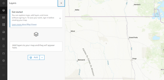 What is happening?
ESRI in the process of making the switch to a ‘new’ map viewer in ArcGIS Online and Portal. As with everything ArcGIS Online is updated more frequently and has the latest and greatest bells and whistles. The migration to the new viewer has been in process for over 2 years - there is not a firm deadline set for when the old map viewer (now titled “Map Viewer Classic”) is going away as there is still some functionality not fully available in the new map viewer.
Some of the features you can look forward to are:
In preparation for the eventual sunset of Map Viewer Classic, and to encourage members to start using the new Map Viewer, the MnDOT ArcGIS Online organizational account will switch the default map viewer from Map Viewer Classic to the new Map Viewer in May of 2023.
Why are we making the switch?
As mentioned ESRI has already committed to this switch, and we want people prepared for when it eventually happens. Additionally, all the new bells and whistles added to ArcGIS Online are happening to the new Map Viewer – and there is a ton of new functionality available, though it may take some time to learn how to navigate it.
Can I still access Map Viewer Classic?
Members will still have access to Map Viewer Classic, to get to it:
-
Open the layer directly in Map Viewer Classic from the Item information page - click on the down caret ‘⌄’ next to map viewer and pick “Open in Map Viewer Classic” from the drop down.
-
Within an already open the Map Viewer instance – switch map types with the button in top right labeled “Open in Map Viewer Classic.”
| Back to top |
MnDOT launches first multimodal trip planner to focus on rural transportation services
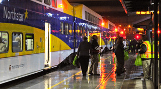
Mobile app to make travel easier in Greater Minnesota, Rochester, Mankato
Office of Transit and Active Transportation (OTAT)
When a person wants to take a trip across the country, they can choose from a variety of travel planning apps to help make that happen. But what if the trip they want to take is from Mankato to New Ulm, or within their own community, using non-personal transportation?
The Minnesota Department of Transportation has launched a pilot project to bring trip planning and payment technology for daily trips in areas less dense than in an urban setting.
Residents and visitors in southern and western Minnesota now have the ability to plan for and, in some cases, pay for public transit and intercity bus trips by using the Transit app. Travel and route information for these agencies went live within Transit on March 1.
Transit, a free app available for download in Google Play or the Apple App Store, is used in more than 300 cities around the world. It allows users to see route and travel options for public transit and connecting services. Select transit agencies will also have in-app ticketing, allowing riders to pay for fares electronically and show their device to bus drivers to ride.
“This pilot with Transit app focuses on rural areas because this technology has not yet been made available outside of Minnesota’s big cities,” said Elliott McFadden, who serves as MnDOT’s Greater Minnesota Shared Mobility program coordinator. “The project will be the first to bring the latest technology to make it easier to plan and take trips in many communities in Greater Minnesota.”
The pilot will run through April 2024 and is funded by two innovation grants from the Federal Transit Administration at a cost of $1.9 million. Researchers from the University of Minnesota will study both of the projects to help determine whether this technology should be scaled to the rest of the state, with the goal of better informing future public transit investment in Greater Minnesota.
Participating transportation providers include (* indicates in-app ticketing will be available):
-
Brown County Heartland Express
-
Central Community Transit
-
Jefferson Lines (by mid-March)
-
Land to Air
-
Morris Transit*
-
Mankato Transit System*
-
Minnesota River Valley Transit
-
Prairie Five RIDES
-
Rochester Public Transit (by the end of March)
-
Rolling Hills Transit*
-
SMART*
-
The Otter Express*
-
Tri-CAP*
-
TRUE Transit
-
UCAP Community Transit
By Joseph Palmersheim
|
| Back to top |
Transportation Trivia
On what Minnesota lake was water skiing invented in 1922?
MnDOT invites and encourages participation by all people in their programs, services and activities.
If you need an ASL, a foreign language interpreter, or documents in an alternative format (such as braille, large print or in a different language) at no cost, please email your request to Janet Miller at ADArequest.dot@state.mn.us or call 651-366-4720. Relay service: 711.
If you need any other reasonable accommodation to participate (such as seating modification or auxiliary aids), please email your request to Accessibility.DOT@state.mn.us or call 1-833-400-8432. Relay service: 711.
| Back to top |
|