March 17, 2021
In this newsletter
 |
|
The iHub GIS site serves as the one-stop location to disseminate MnDOT GIS-related information concerning everything from data access, software, map services, applications, imagery and training.
For quick access to MnDOT commonly used GIS applications, e.g. Georilla, EMMA, CHIMES, MnMap (MnDOT ArcGIS Online), RWMM, RACER, RPMA, RLC, TAMS, etc., click here and bookmark to your browser.
|
Project Spotlight: Building Regional Datasets for Greater Minnesota Transit
 |
|
The Office of Transit and Active Transportation (OTAT) is exploring new territory with GIS in 2021, beginning their development of a regional web mapping application for Greater Minnesota transit systems and their users. Read more:
|
What's New in District 1?
District 1 gained dedicated GIS support with John Stasiak coming onboard last September. John graduated from Northern Michigan University in 2017 and comes to us from Grand Rapids, MI where he worked as a GIS Specialist for AECOM’s environmental consulting team. During his time with AECOM, John served as the GIS lead for data collection, management, and analysis efforts surrounding groundwater and soil sampling.
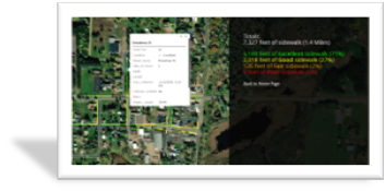
Now at MnDOT, John supports the GIS needs of all functional groups in District 1, including creating maps for project scoping, mapping the Capital Highway Investment Plan (CHIP), and providing geographic information to aid with public meetings and financial planning. John also seeks to build a well-rounded ArcGIS Online presence to improve functions such as field data collection, interactive web mapping, and data sharing. Most recently, John developed a data collection app for rating sidewalk conditions in the District. The results of this survey will guide municipalities when applying for Safe Routes to School (SRTS) grant funding to improve pedestrian travel to and from schools.
|
Upcoming GIS Bytes Webinars
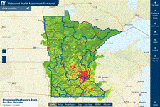
Watershed Health Assessment Framework
Tuesday March 23, noon - 1:00
Where is the watershed you live in? How's the watershed’s health? Kitty Hurley and Ben Gosack will dig into the Watershed Health Assessment Framework (WHAF) and showcase tools that break down the barriers to accessing and interpreting watershed data. Ben and Kitty will highlight uses of the WHAF tools to benefit natural resource managers and Minnesotans. In addition, we will explain our technology stack, including PostgreSQL, Flask, Plotly and Angular.js.
Ben Gosack is a GIS Analyst with DNR Ecological and Water Resources
Kitty Hurley is a Senior GIS Developer with MNIT DNR
Download the Teams meeting invitation for details. Questions? Contact Bob Diedrich
|

Using Spatial Technology to Deliver Actionable COVID Information
Tuesday April 6, noon - 1:00
In recent months, MnGeo was tapped to help with three COVID applications. Blaine Hackett will describe these three applications and describe the challenges of each:
- COVID for Public Safety Answering Points (PSAP) – Using the MnGeo geocoding service to email encrypted information to PSAPs
- COVID Testing and Vaccine Site webpage – Public-facing webpage where users can search for a test or vaccine site
- COVID Vaccine focus communities, gap and capacity mapping – Using GIS mapping and analysis tools to ensure focus communities have equal access to vaccination
|
Blaine Hackett is a the Portfolio Manager at MnGeo.
Download the Teams meeting invitation for details. Questions? Contact Bob Diedrich
In Case You Missed It - Recent GIS Bytes:
1/14/2021 GIS and Gender – Alison Slaats and Sally Wakefield (View Recording here).
2/18/2021 Hands on GIS Training! - Anne Morris and Jason Ewert (Yammer, MnDOT GIS) (View recording here).
Ongoing Virtual Training: Intro to GIS (ArcMap)
 |
|
The MnDOT GIS Support group is offering a new virtual training for beginners in GIS. The participants in this training will take five ESRI web courses for basic knowledge and skills in ArcMap, with a Teams Meeting at the end for getting connected to MnDOT GIS resources. Questions, comments, or interested in registering? Send an email to Ruojing.Scholz@state.mn.us. Additional courses may be scheduled this summer or fall depending on demand.
For a detailed course description and dates, click here:
|
May the Fourth Be With You: Spring GIS User Group Workshop
 |
|
The 2021 Spring GIS User Group workshop is coming up on, you guessed it, May 4th! It will be held virtually on Microsoft Teams. Full schedule details can be found here:
|
ESRI Online Courses for Entry-Level ArcGIS Pro
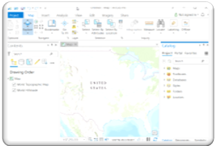
Eager to learn Pro? Try these ESRI online courses!
- Click the course name and link.
- Log in with your MnDOT ArcGIS Online (AGOL) account. Don’t have an account, contact AGOL admin Bob Diedrich (Diedrich@state.mn.us) or Andy Trcka (Andrew.Trcka@state.mn.us).
- Click the Launch Course button to start. In the software version pop-up window, select ArcGIS Pro 2.5.
- You may stop and resume the course any time. Your course progress will be saved. If you have ArcGIS Pro open, save your project (click on the upper left corner) before closing the software.
|
A Word from MnIT @ MnDOT
Mapping and the use of GIS is a rapidly evolving discipline. Amongst other things, the ancient practice of cartography has evolved to include drones, field collection data applications, geospatial web services and online maps. Advances in technology have blurred the roles between cartographer, data analyst, planner and application developer. Information Technology (IT) has a unique role in the advancement of GIS in that it provides the software, applications, data and web infrastructure GIS practitioners use to create maps. Given the fast-paced nature of technology and blending of roles, it is often it is difficult to understand where IT ends and GIS user begins.
Future articles in this publication will help you keep pace with the development of mapping technology, understand more clearly how IT helps make technology available to users, and describe upcoming IT projects that impact GIS efforts at MnDOT. Examples of topics we’ll explore include:
- explain Authenticated Directory (AD),
- detail what GIS software is available and how it is installed,
- unravel what geospatial data is available and how to access,
- describe the network infrastructure that MnDOT’s web services and data reside on.
All these topics will help you make sense of how to approach IT for help and understand how IT can impact your projects. Heck…we might even take a moment to explain the various offices within MnIT and how they impact/contribute to the world of MnDOT GIS.
Have a burning tech related idea? Please submit IT related story ideas or questions to any of the following people:
Please submit a GIS support request here. A MnDOT or MnIT GIS coordinator will contact you soon.
For a full list of MnDOT GIS coordinators and key contacts, click here.
MnDOT GIS Newsletter Team
Bob Diedrich - District Operations GIS Support
Ruojing Scholz - Central Office GIS Support
John Stasiak - GIS Coordinator, District 1
Andy Trcka - MnIT GIS Support
Alex Stoiaken - Data Reporting and Innovation Coordinator, OTAT
Galen Kanazawa (Editor) - Student Worker Para Professional
|