|
Idea solicitation for the 2020 academic transportation research program is open. Submit your ideas on Ideascale by Monday, March 16 for consideration in the 2020 research RFP. Ideas submitted after March 16 will be included in the 2021 cycle. MnDOT research implementation projects can be proposed at any time.

Just 20 years ago, the endangered, rusty-patched bumble bee was common in the eastern U.S. and upper Midwest. No longer present in over 90 percent of its known range, the species can still be found in the Twin Cities.
MnDOT’s wildlife management group funded research to count rusty-patched bumble bees in MnDOT roadside green-ways and recommend practices that would improve the species’ chance of survival.
Entomologists from the University of Minnesota studied bee populations at 94 roadside locations, developing a novel surveying method that offers a 95 percent probability of finding rusty-patched bumble bees in areas where they are present. Researchers also identified vegetation and other local factors that improve the bee’s habitat so that MnDOT staff manages roadsides to optimize the survival of the endangered pollinator.
For more information, check out Technical Summary 2019-25 (PDF).
|
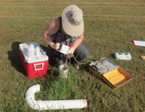
Despite Minnesota’s thousands of lakes and abundant surface water, 75 percent of the state’s water comes from aquifers and is used at increasingly unsustainable rates. Researchers investigated the potential for wastewater reuse at MnDOT’s 137 truck stations and over 50 rest areas, which could save money and conserve water statewide.
Investigators examined station wastewater samples across the state to identify possible contaminants and determined that these could be easily mitigated. They also identified state regulatory modifications that could promote easier waste-water reuse.
The project looked at various waste-water reuse systems and identified two that MnDOT would be able to easily implement and manage: a recirculating sand filter and a membrane bioreactor.
A long-term cost evaluation showed the membrane bioreactor to be the most economical for the agency; one of these has already been installed at Granite Falls and another station, with more sites being considered.
For more information, check out Technical Summary 19-22 (PDF).
|
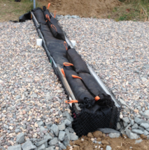
Linear swales, or shallow ditches, can effectively filter pollutants from highway runoff. Research has shown that more contaminants can be removed when ditch checks are installed along the swale. A ditch check is a low, permeable mound placed in the swale to slow water flow and remove more pollutants. Research was needed to monitor the performance of an existing Washington County ditch check designed with an iron-enhanced filter intended to remove phosphorus.
Through extensive monitoring and laboratory tests of collected samples, researchers showed that the iron-enhanced filter successfully removed phosphorus during the majority of the 40 rain events over the non winter months, reducing the phosphorus mass loads between 22 percent and 54 percent. Copper and zinc were not retained. They also recommended modifying the filter’s orientation to increase its effectiveness and simplify routine maintenance.
For more information, check out Technical Summary 2019-27 (PDF).
|
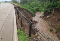
Heavy rainfalls have become more frequent in Minnesota, and annual precipitation levels are climbing. Slopes near highways suffer when rainfall combines with flooding, frost action and geological factors to destabilize slopes and cause failures.
In two phases of research, investigators developed maps of roadways in 44 of Minnesota’s 87 counties that chart slopes within a half-mile of roadways in 10-meter-by-10-meter units. Areas are color-coded for their vulnerability to failure based on slope shapes, proximity to risk factors like streams and past failures.
Available as PDFs and 20-by-30-inch posters, these maps point time-strapped state and county engineers toward slope segments that may require monitoring, future inspection or immediate attention. Research is in motion to finish mapping the entire state.
For more information, check out Technical Summary 2019-12/18 (PDF).
|
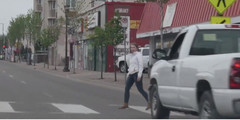
Traffic-related pedestrian deaths have been increasing in Minnesota. In 2016, there were 60 pedestrian fatalities, the highest number since 1991. The trend continues in 2019. In response, researchers investigated the Stop for Me campaign, which is sponsored by the St. Paul Police Department and community partners, to determine if this multifaceted, integrative program changed drivers’ yielding behavior at crosswalks.
Researchers monitored the effects of the program’s educational outreach strategies of flyers and online materials, high-visibility enforcement (warnings and tickets), and low-cost engineering treatments, such as one or more intersection signs placed across the 16 study sites.
Results showed significant improvement in drivers’ yielding behavior over the course of the program. At the start of the project, the yielding rate was a very low 31.5 percent. The rate rose to 78 percent during a multiple street sign installation effort. This multifaceted, focused program, which successfully altered driver behavior and made crosswalk yielding the norm, could be easily transferred to other cities and communities.
For more information, check out Technical Summary 2019-29 (PDF).
|
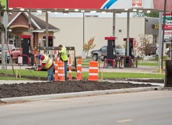
MnDOT’s Office of Public Engagement and Constituent Services funded a study to determine how road agencies in Minnesota and other states manage construction projects to mitigate the impact of road work on local businesses.
Research and a survey of practice showed that every surveyed state and local agency recognizes the need to engage local business owners and the community in activities that communicate and reduce project impacts.
The most effective practices include virtual meetings and animated project models, Facebook and Twitter, and project communication panels formed locally by area businesses and citizens. These local groups work with transportation agencies, contractors and the public to issue weekly and sometimes daily updates about big projects and areas where traffic impacts will be felt.
For more information, check out TRS 1901 (PDF).
|
The 2019 At-A-Glances for the MnDOT Office of Research & Innovation and Local Road Research Board are now available. They serve as quick-reference guides to the state and local research programs—including project highlights, an overview of the research process, and information about our transportation research synthesis program.
Visit MnDOT's Office of Research & Innovation to read the full reports.
|
|


