A newly funded study is investigating how to use noise barriers and snow fences on Minnesota highways to harvest clean, cost-effective energy. Using surveys, lab testing, modeling and a cost-benefit analysis, MnDOT sponsored researchers aim to determine whether it is possible to add solar panels to these structures cost-effectively while maintaining functionality.
“Snow fences are intended to limit snow from drifting onto our highways, while noise walls are intended to reduce noise to a comfortable level for communities living near our highways. Finding a way to integrate solar that maintains their structural integrity could transform the use of these barriers from single purpose to multipurpose,” said Dan Gullickson, MnDOT’s blowing snow control shared services coordinator.
“We’ve seen some applications of solar panels on noise walls—primarily in European countries—but the addition of solar panels to snow fences is an entirely new concept,” he said.
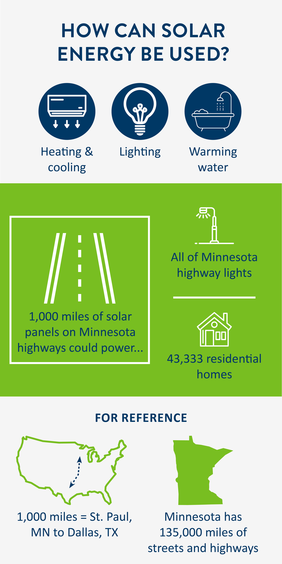
One estimate shows that a thousand miles of solar panels could power all the streetlights along Minnesota highways or 43,333 residential homes. The hope is to create a sustainable solution that aids drivers and farmers, and also offsets the cost of construction and installation.
The study, conducted by North Dakota State University, is scheduled for completion by June 2021. Follow along for project updates on MnDOT's Office of Research & Innovation website.
|
At intersections with no signals, the chance of a crash increases if a stopped driver can’t see far enough down the major road to accurately judge gaps in traffic. But how far is far enough?
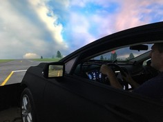
Researchers at the University of Minnesota’s HumanFIRST Laboratory tried to answer this question using a state-of the-art driving simulator (pictured below). With 36 participants in driving trials, they tested sight distances of 400, 600 and 1,000 feet while driving on a simulated rural road with 18 minor thru-stops and waiting at nine simulated intersections.
With 1,000 feet of sight distance, drivers were much more effective at crossing and could even respond effectively to a stop-sign-running car—often a catastrophic crash scenario. These results will help local agencies prioritize cutting brush and trees at these intersections and will affect decisions on how close to the major road to put the stop line, as a closer stop line means more sight distance.
For more information, check out Technical Summary 2019-34 (PDF).
|
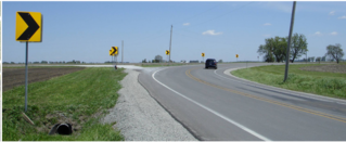
Accidents at horizontal curves on two-way, two-lane Minnesota highways account for about 70 deaths each year, roughly one-fifth of roadway fatalities in the state. Dynamic message signs (DMS) with speed detection and electronic message boards work very well to warn drivers and improve safety, but cost about $14,000 each.
Since 2015, MnDOT and the Local Road Research Board have been funding the development of an alternative technology to DMS. The latest approach uses GPS and cloud-based roadway data to send a silent, on-screen warning to drivers who are traveling too fast for approaching curves. Soon after, if the vehicle hasn’t slowed sufficiently, the system sends an audible message and flashing screen image.
“The application stitches together existing technologies in a cloud-based warning system,” explained Otter Tail County Public Works Director Richard West.
Although a proof-of-concept smartphone application was used to relay warnings to drivers, the data could be incorporated into navigation systems and in-vehicle systems via the cloud.
Researchers estimate that if a commercial developer adopts the application, the software and cloud-based warning database could be maintained and updated for about the cost of a single DMS.
A related project is exploring the possibility of using vehicle-to-vehicle communications in producing the driver warnings.
For more information, check out Technical Summary 2019-19 (PDF).
|
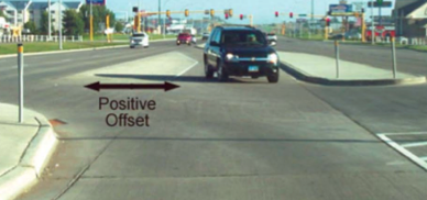
About one-quarter of the severe crashes that occur at Minnesota four-way intersections involve left-turning vehicles. When left-turn lanes of opposing traffic are positioned exactly opposite or in a closer overlapping pattern, the turning driver can’t see oncoming traffic.
To effectively revise MnDOT’s Road Design Manual, a new report analyzes research and other state agencies’ manuals on the advantages of positive offset left-turn lanes, which are lanes designed specifically to provide drivers with an unobstructed sight line of opposing through traffic.
Investigators found a wealth of research supporting this practice: One Wisconsin study showed a 33.8 percent reduction in total crashes over 12 years. The updated manual will include standards, policies and guidance for new, reconstruction and preservation projects, and will cover designs for both urban and rural multilane roadways, including considerations for pedestrians, bicycles and winter maintenance.
For more information, check out Technical Summary 2019-32 (PDF).
|
State and local agencies in Minnesota maintain over 20,000 steel and concrete bridges. Cleaning and repainting corroded spots on steel bridges can extend bridge service life, protect the steel from corrosion at beam ends, joints, bearings and other locations, and limit budget stresses on road agencies.
MnDOT requested research on promising maintenance painting products that crews could use with minimal surface preparation to extend coating service life. Researchers tested five coating systems on bridges and found that all can be effective. Properly timing maintenance coats is critical to durability. If agencies act promptly after inspectors identify corrosion, the necessary cleaning before recoating can be minimized and corrosion reduced, extending service life and giving budgets more flexibility.
For more information, check out Technical Summary 2019-37 (PDF).
|
Transportation agencies have lagged behind architecture in transitioning away from paper-based design, but federal agencies are encouraging us to move to civil integrated management (CIM), which allows everyone involved in large infrastructure projects to work together using emerging digital technologies such as 3D modeling, lidar, electronic document management and other tools to deliver complex projects efficiently and safely.
The Local Road Research Board funded research to present and clarify how using CIM tools would affect a local project—a road project in Carver County—from its initiation to approximately 30 percent of completion. Tools and processes included 3D survey “reality capture” with high-resolution imaging performed via drone, integration of geographical information system (GIS) overlays into digital project files, 3D decision support of road corridor choices and rapid evaluation of alternative road profiles. CIM would have reduced the Carver County project by 40 workdays, primarily in surveying time and in examining alternative choices.
Researchers described the potential benefits in this local context. They also developed key steps that Minnesota counties and cities could take to effectively promote and incorporate CIM tools and processes into their projects. Though more preparation is needed for such a major technology shift, this project offered many strategies agencies could employ to begin moving into the inevitable CIM future.
For more information, check out Technical Summary 2019-36 (PDF).
|
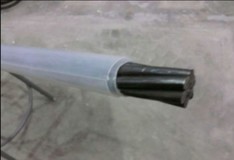
Prestressed concrete beams, used frequently on bridges, require fabricators to stretch steel cables along the length of a concrete form, pour the concrete and then release the strands once the concrete has set. These precompressed beams distribute force from heavy truck loads along the length of the beam, improving bridge performance and durability.
To prevent prestressing from leading to cracking caused by strains at beam ends, MnDOT requires fabricators to deploy strands in challenging patterns that lead to thicker and more expensive beams. Other states wrap select cable ends in sleeves that prevent concrete from bonding directly to strands. With this approach, users have debonded up to 60 percent of strands with no notable water and road salt incursion.
MnDOT is now testing debonding in two pilot projects. If the bridges perform well, Minnesota may move toward widespread adoption of debonding, reducing strain on beam ends, as well as on fabricators and local agency budgets.
For more information, check out Technical Summary 2019-30 (PDF).
|
|


