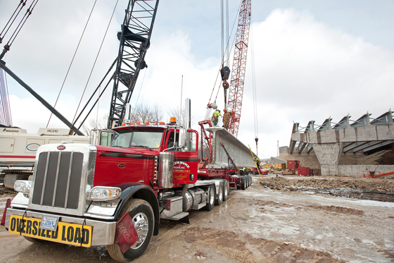
MULTIMODAL — Hauling equipment to highway or large construction sites regularly involves wider and heavier loads than roads were designed to accommodate. To minimize pavement damage and ensure the safety of transport personnel, transportation agencies issue permits to haulers after reviewing proposed routes to work sites.
Most routes of this sort involve multiple local roadway authorities — state, county, city or township — each of which may have different procedures for applying for a permit. Some permits may take weeks to process, which only encourages haulers to simply risk ignoring the requirement.
To simplify the permitting process, MnDOT and the Local Road Research Board teamed up to explore the feasibility of a unified permitting process.
Researchers produced a proof-of-concept (Report 2017-26) for developing a one-stop permitting process that would allow commercial haulers to plan a travel route and secure all required permits from a single source. MnDOT is working to develop a first-of-its-kind, unified permitting process to consolidate the requirements of every jurisdiction in the state into a single, quick-response platform that meets the needs of haulers.
Technical Summary 2017-26
 MULTIMODAL — MnDOT commissioned a Transportation Research Synthesis to survey other state departments of transportation on the software systems they are using to manage freight permits and motor carrier credentials. The survey investigated various topics, including how other states issue permits online, and whether permitting and credentialing can be accomplished using a single, integrated system.
This very detailed survey was administered to 11 selected agencies expected to have experience with these systems. Questions covered system functional and reporting capabilities, costs, benefits and drawbacks. Seven of the states reported offering some online permitting, but no agency currently uses a single system to manage both permitting and credentialing. As usual, MnDOT is ahead of the curve in pursuing this kind of innovation.
Transportation Research Synthesis 1704
|
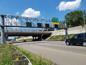 TRAFFIC AND SAFETY — Active traffic management has been deployed on two Twin Cities freeways. This technology involves intelligent lane control signals placed over selected lanes at half-mile increments to warn drivers of incidents ahead.
As an enhancement to this system, MnDOT has now developed and tested warnings to alert drivers to slow traffic ahead. This innovation should reduce rear-end collisions, the most frequent type of freeway crash. Over three months, in locations where the new messages were used, there was a 22 percent decrease in crashes and a 54 percent decrease in near-crashes as compared to 2013. These results are extremely promising, but a longer trial period will still be needed to ensure that these benefits are sustainable.
Technical Summary 2017-20
|
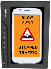 TRAFFIC & SAFETY — How can we best warn drivers that they need to slow down when approaching a work zone? MnDOT puts up signs, but could warnings also come from inside cars, just as smartphones currently issue warnings about dangerous weather conditions? MnDOT administered a survey to drivers about this possibility and developed a driving simulation study to see whether these in-vehicle messages would distract drivers. Findings indicated that drivers were open to the idea and that their performance actually improved following delivery of audiovisual phone messages. The messages were definitely more effective than signs alone. The project is ready to advance to field testing on a test track and on real roadways.
Technical Summary 2017-19
|
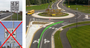 TRAFFIC & SAFETY — Roundabouts are definitely safer than traffic signals, but multilane roundabouts have proven more hazardous than single-lane roundabouts, with drivers sometimes failing to yield or exiting the roundabout by turning directly from the inner lane. Investigators tried different signage and lane marking strategies and, using video observation, were able to identify some signs as particularly confusing to drivers. The study identified effective solutions for reducing turn violations, but did not determine how to get drivers to yield properly. This latter task will require trying more traffic control strategies with more observations; a pooled fund effort involving several states may be one option.
Technical Summary 2017-30
|
 MULTIMODAL — Minnesota cities and counties want to promote bike use, and MnDOT’s Complete Streets program encourages using roadway space for bicycle facilities. But how do cars and bikes really interact on roadways? How do different bike lane designs affect traffic? For 51 days, investigators video-monitored nine sites that involved various bike lane configurations like striped bike lanes, shared-use arrows, signed shared lanes and shoulders of various widths. An analysis of this footage found that using striped or buffered bike lanes is more effective than other strategies at keeping drivers from encroaching on adjacent bike lanes. The most problematic situations occur when cars line up behind bicyclists, and this happened most often on roads without bicycle facilities and on roads with shared facilities but no marked lanes.
Technical Summary 2017-23
|
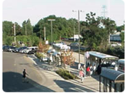 MULTIMODAL — Park-and-ride lots throughout the Twin Cities metro area provide parking for commuting suburban transit users. But how far can one of these lots reasonably be located from the bus or rail hub without annoying its transit users?
Investigators surveyed over 500 park-and-ride users about their travel habits and about various aspects of areas they might have to walk through to reach the transit station: How safe are the intersections? Are there sidewalks and benches? What do the buildings look like? The study found that users are generally willing to walk about three blocks (0.3 mile), but could be induced to walk 1.8 blocks farther in an environment with safe intersections, adequate snow removal and street lighting, and a good sidewalk network.
Final Report 2017-29
|
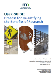 POLICY & PLANNING — Researchers worked with MnDOT technical experts to develop a method for identifying the financial and other benefits of research projects. This seven-step process for quantifying benefits was applied to 11 recent projects, and the research cost of $1.98 million for the projects is expected to
save an estimated $68.6 million for MnDOT and Minnesota cities and counties over a three-year period, for a benefit-to-cost ratio of about 34-to-1. The expected savings will be enough to pay for the research budget for six or seven years.
Technical Summary 2017-13
|
 |
|
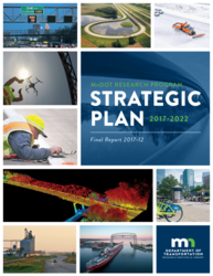
POLICY & PLANNING — MnDOT has developed a new plan for 2017-2022 to focus its research strategy in support of MnDOT’s vision and mission given the latest transportation trends. The plan development involved extensive stakeholder engagement and a review of best practices for transportation research programs. A communication strategy was also adopted for conveying the value of our research and promoting statewide adoption of innovations.
Final Report 2017-12
|
 FLOOD DAMAGE — MnDOT knows the damage flooding can do to our transportation system. A June 2012 flash flood closed a two-mile section of Highway 210 in Jay Cooke State Park. To reopen a route that would be safe for the public, reconstruction needed to repair current damage and prevent future damage from flooding and erosion. Crews stabilized slopes using innovative solutions like geo-web walls and anchor-reinforced vegetation and installed sensors to monitor ground movement. The highway officially reopened Oct. 4.
A video is available at dot.state.mn.us/d1/projects/Hwy210future.
Learn more about MnDOT efforts to
prevent flood damage on Minnesota roads.
|
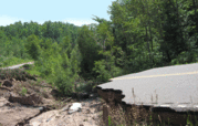
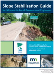 FLOOD DAMAGE —Damaged slopes along highways and bridges can lead to damaged roads and embankments. The Local Road Research Board funded a project to help local engineers identify types of slope failure and select an appropriate repair method.
They examined 14 destabilized sites, analyzing soil samples from each; identified 12 potential stabilization techniques from a literature search; and used computer modeling to examine the viability of various techniques at sites where soil was sandy, fine-grained or rocky.
The resulting guide includes a simple, three-step flowchart for selecting the most appropriate repair technique for each situation. It also includes photographs and detailed repair procedures.
Slope Stabilization Guide
|
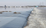 FLOOD DAMAGE — To help prevent floodwaters from causing erosion and road damage, researchers monitored flood-prone locations near the Red River periodically from 2013 through 2016 and conducted laboratory experiments using a simulated section of roadway. They tested three erosion protection techniques that are alternatives to riprap and other hardscapes. For example, roadsides can be covered with a flexible concrete geogrid mat that allows vegetation to grow through it.
“This project developed a fairly complete matrix of useful erosion protection measures that our own staff can implement - techniques that are less elaborate and more cost-effective than hiring contractors,” J.T. Anderson, Assistant District Engineer, MnDOT District 2, said.
Further study of these techniques will be required before definitive recommendations for changes in practice can be made.
Technical Summary 2017-21
|
11/1
TRIG Fall Meeting
11/2
28th Annual CTS Transportation Research Conference
11/16-17
APWA-MN Fall Conference
11/20
LRRB RIC Meeting
11/28-29
TRIG Winter Meeting
12/6-7
LRRB Winter Meeting
|


