May 2026
 There's a Map for That! 🗺️🧭
Ready to chart your next adventure? This month, we’re putting maps front and center—your guide to discovering everything Minnesota state parks and trails have to offer. Whether you’re tracing a winding river, finding the perfect campsite, chasing peak fall color, or planning your next winter adventure, there’s a map to help you get there. From detailed park and trail maps to real-time condition tools, these resources make it easier than ever to plan, explore, and experience something new.
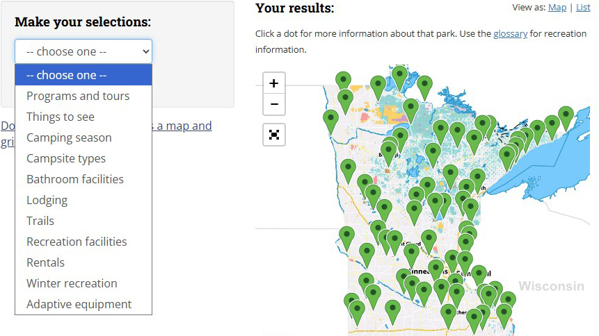  ParkFinder 📍
The ultimate interactive map for Minnesota recreation.
Have you used ParkFinder yet?! ParkFinder is an incredible tool for finding your next state park adventure. The free, interactive map allows you to filter by options including things to see, trail types, winter recreation, and more! If you've ever wanted to see a map of all the state park waterfall locations—this is your tool. Don't forget to check out the rentals filter to see where canoe, kayak, and paddleboard rentals are available!
Once you pick your destination, always check the park's visitor alerts and seasonal information before heading out. Severe weather and equipment maintenance can impact the availability of offerings—individual park webpages will have the latest information on closures or changes.
👉 ParkFinder is available on the DNR website. The information is also listed in the State Parks and Trails Visitor Guide, which is available at all park ranger stations. You can request a print copy by emailing info.dnr@state.mn.us.
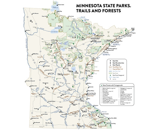
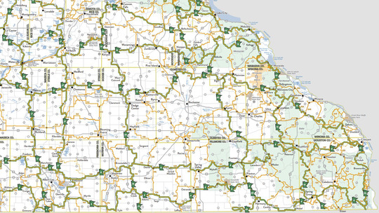
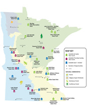
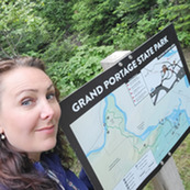
 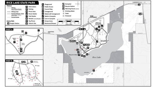 State Park and Recreation Area Maps 🏞️
Must-have information for any state park visit.
State park and recreation area maps are designed to help you quickly understand what’s available and how to explore it. From scenic lookouts and beaches to picnic shelters and hiking trails, park maps are your go-to source for discovering what each park has to offer.
-
Find key features at a glance: Scenic lookouts, beaches, picnic shelters, trails, and more are clearly labeled to help you plan your visit.
-
Seasonal map options: Many parks offer summer and winter maps that reflect changing trail uses, from hiking and biking to skiing and snowshoeing.
-
Campground maps: Some parks provide separate campground maps to help you find your site, locate bathrooms and water, and get your bearings.
-
Helpful information on the back: The back of the map includes trail highlights, ideas for shorter visits (like “if you only have an hour”), visitor tips, and the park’s address and phone number.
👉 Digital state park maps are available on the park's webpage. You can get a print copy at the park ranger station.
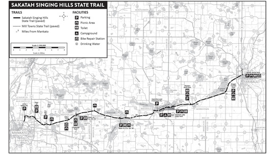 State Trail Maps 🛣️
Find parking, pick your activity and start route planning.
State trail maps are designed to help you understand what to expect before you hit the trail. Whether you’re planning a short walk or a longer ride, these maps clearly show trail surfaces, allowed uses, and key amenities along the way.
-
Know the trail surface: The front of the map identifies whether the trail is paved, unpaved, or natural surface, helping you choose the right experience.
-
Understand allowed uses: Maps indicate which activities are permitted, including biking, horseback riding, OHV or ATV use where applicable.
-
Locate amenities: Parking areas, picnic shelters, bathrooms, and other features are marked on the front of the map for easy planning.
-
Learn about the landscape: The back of the map describes the scenery you’ll travel through, from forests and prairies to farmland and river corridors.
-
Plan for elevation changes: An elevation profile on the back of the map shows climbs and descents along the trail.
-
Find places to start: Trailhead and parking location addresses are listed to help you plan your route.
👉 Digital state trail maps are available on the trail's webpage. State parks will often keep print copies of nearby trail maps at their office.
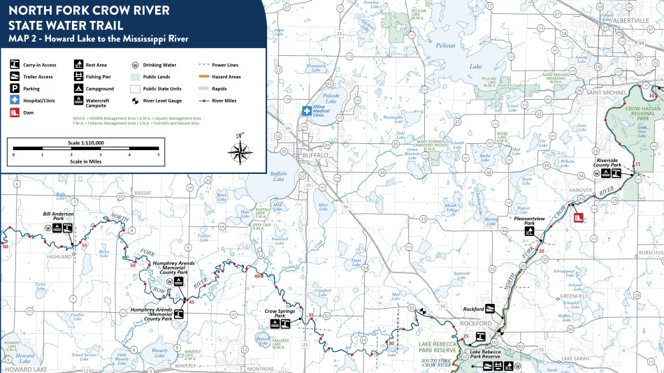 State Water Trail Maps 🌊
The ultimate resource for when you're ready to hit the water.
State water trail maps are packed with information to help you plan a safe and enjoyable trip on the water. From navigating river routes to identifying access points and amenities, these maps are an essential tool for paddling adventures.
-
Follow the route: The front of the map shows the full water trail with river miles clearly labeled to help you track your progress.
-
Navigate safely: Hazards, rapids, and dams are identified, along with key safety considerations along the route.
-
Find access and amenities: Locations for rest areas, watercraft campsites, trailer access, restrooms, and more are marked to support trip planning.
-
Understand the landscape: The back of the map provides an overview of the scenery and environment you’ll experience along the route.
-
Plan your trip: Recommended day trips are also on the back of the map, helping you choose routes based on time and skill level.
-
Be prepared: Safety tips, nearby medical centers, and DNR contact information are listed for added peace of mind.
👉 Digital state water trail maps are available on the water trail's webpage. State parks will often keep print copies of nearby water trail maps at their office.
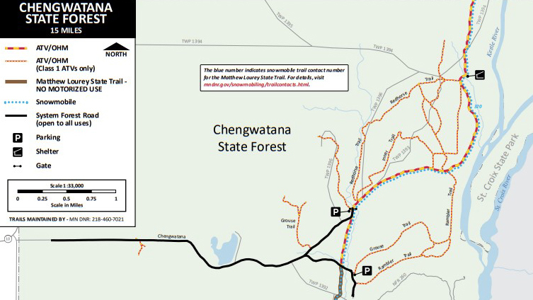 OHV Trail Atlas 🚙
Maps for all OHV trails on state lands in one place.
The Off-Highway Vehicle (OHV) Trail Atlas is your go-to guide for exploring motorized trails across Minnesota. This comprehensive atlas brings together dozens of trail maps, along with important safety information, riding rules, and trip-planning details to help you make the most of your ride.
-
Explore trails statewide: The atlas includes maps and descriptions for dozens of OHV trails, helping you discover new riding opportunities across Minnesota.
-
Understand trail designations: Maps identify where different types of OHVs are allowed, along with state forest classifications and trail systems.
-
Plan your route: Directions, trail connections, and key access points are included to help you get to and navigate each trail.
-
Know before you go: Safety information, riding rules, and guidelines are built into the atlas to help ensure a responsible and enjoyable ride.
👉 The digital OHV Trail Atlas is available on the DNR website. State parks will often keep print copies at their office. You can request a print copy by emailing info.dnr@state.mn.us.
 Snowmobile Maps ❄️
Maps by region for snowmobiling trips statewide.
Snowmobile maps help you navigate one of the largest trail systems in the country with over 22,000 miles of groomed trails across Minnesota. Riders can choose from regional print maps—Northwest, Northeast, Southwest, and Southeast—or use the online interactive map to view the entire system in one place.
-
Explore by region: Section maps break the state into Northwest, Northeast, Southwest, and Southeast for easy trip planning.
-
See the full system online: The interactive map combines all regions, helping you plan longer routes and connections.
-
Find your way with confidence: Trails are clearly marked to guide you through forests, lakes, and communities across the state.
👉 The interactive snowmobile map is available on the DNR website. You can request a print copy by emailing info.dnr@state.mn.us.
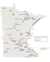
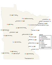
 Overnight Options and Recreation Maps
Online-only maps that highlight special options.
|
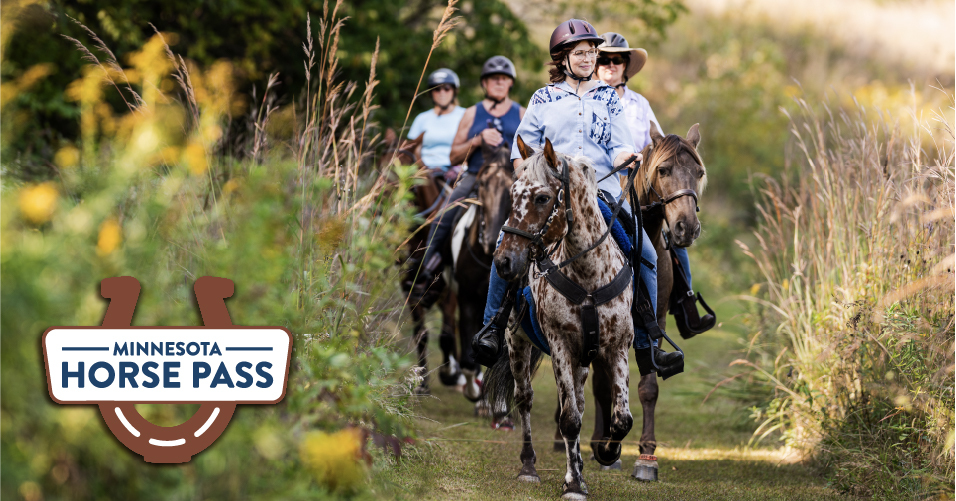
Horseback Riding 🐎
The statewide horseback riding map highlights where equestrian trails are available across Minnesota state parks, trails, and forests, making it easy to discover new places to ride. Most horse trails are typically open from May 1 through November 1, depending on weather and trail conditions. Riders age 16 and older are required to have a Horse Pass to use any of the trails shown on the map. For more detailed planning, each location also provides site-specific maps with designated horse trails, trailheads, and amenities to help you plan your ride.
|
|
 |
|
Winter Camping 🏕️
The winter camping map highlights which Minnesota state parks offer camping opportunities during the winter months. It shows where you’ll find electric and non-electric campsites, along with lodging options, and identifies available amenities such as showers, firewood, drinking water, and rental equipment like snowshoes and skis.
|
|
 |
|
Camper Cabins 🛖
The camper cabin map makes it easy to see where cabins are available across the system. It shows how many cabins each location offers and whether they are seasonal or available year-round. The base map also highlights Minnesota’s major landscape regions—such as prairie, tallgrass aspen parklands, deciduous forest, and coniferous forest—helping you choose a setting that fits your ideal getaway.
|
|
 |
Real-Time Condition Maps 🔥
Think heat map...except snow, fall colors, or drought.
|
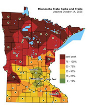
Fall Color Finder Map 🍁
The Fall Color Finder map tracks the progression of autumn color across Minnesota in real time, helping you plan the perfect leaf-peeping trip. Updated weekly from early September through late October, it shows where fall colors are at their peak, just starting, or past their prime. The map also includes an alternate color scheme option for those with red-green color vision deficiencies, making it more accessible for all users. Subscribe to the Fall Color newsletter to have this map sent to your inbox every week in the fall.
|
|
 |
|
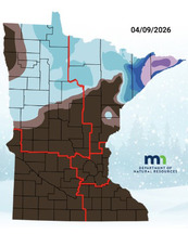
Snow Depth Map ❄️
The snow depth map shows current snow conditions across Minnesota, helping you find the best places for winter recreation. Updated weekly from roughly December through March, it displays how much snow is on the ground so you can plan activities like skiing, snowshoeing, or snowmobiling. The map also includes an alternate color option for those with color vision deficiencies, making it easier for all users to interpret conditions at a glance.
|
|
 |
|
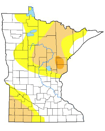
Drought Map ♨️
The drought map shows how dry conditions are across Minnesota, ranging from no drought to exceptional drought. Updated based on precipitation reports, it helps illustrate where conditions are developing, improving, or becoming more severe across the state. Understanding drought conditions can provide helpful context for your visit—shaping the current landscape, influencing the timing and intensity of fall colors, and even affecting recreation opportunities like paddling water levels.
|
|
 |
 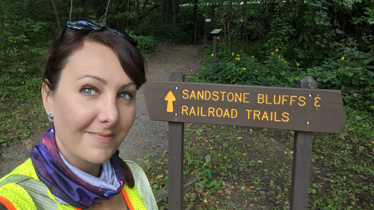 Meet the Cartographer: Amy Ellison
Every state park and trail map has Amy's fingerprints on it.
As a kid, Amy Ellison decided her dream was to be an archeologist. She spent hours watching PBS specials and envisioning trips to far-off places with her nose in an atlas. However, after heading off to college for archaeology, she found that her interests lay more on the earth’s surface than below and changed her major to geology.
Amy started her cartography role at the Minnesota Department of Natural Resources just six months out of college and has been an employee for the full 27 years since. Her position originally focused mainly on state trail maps. Amy now manages over 800 maps for Minnesota’s state parks AND trails—online maps, geo-maps, paper maps, and signs. Believe it or not, there is only one parks and trails cartographer, and that’s Amy! For a long time, she was one of the only female GIS (Geographic Information Systems) Scientists at the DNR.
Over her 27 years, Amy has witnessed the transition from handwritten to digital map creation. For many years, her database was small, and mapping was manual. The drafter’s desk was her workstation. She would manually stamp letters, use stencils to add way-point arrows, and draw straight lines for the trails. She recalls those years as a really fun time to work in the field of cartography—all of her skills were showcased with each map.
When the work transitioned to sitting at a desk, it could take Amy’s computer two hours to open a large map file. But these days, a mapping project that used to take two weeks now takes just two hours. Amy still believes mapping is an art form, but the practice looks much different. All of her work is digital, other than the occasional state park visit to check mileage or landmarks.
Every single map you see in the parks has been on Amy’s desktop at one point. In order to manage and modernize maps, she has worked closely with DNR field scientists to develop new tools and data collection apps to track mileage and have the data sent straight to her.
A lot of Amy’s time is also spent ensuring the DNR’s maps are accessible to all, an aspect of her work that has always been at the core of her career. During college, one of her cartography professors had color vision deficiency and taught students to pay attention to the needs of everyone who would be reading their map. Amy says that one of her favorite parts of her job is hearing what visitors want out of the maps. “I enjoy hearing public feedback and figuring out a solution. It gives me a new challenge, which can sometimes lead to a new map.”
|
|