|
The Maumee River Basin Commission and city of Wayne, Indiana recently created a fun short Flood Safety Public Service Announcement (PSA) featuring "Flood Safety Dan."

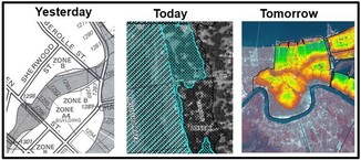
They discuss that just because a site is outside of the mapped floodplain on the official FEMA map doesn't mean that site is safe from flood risk!
The video's focus is a State of Indiana portal that shows flood risk mapping based on updated data.
It's a good reminder that the Minnesota official FEMA maps are often based on old and incomplete data. Many watersheds and communities have updated maps based on newer data, and many counties are in the process of getting updated flood risk mapping and data. Communities can use that updated mapping and data to communicate about flood risk or for regulation (if it is more stringent than the FEMA mapping).
See Flood Safety PSA 2025 (about one minute).
|
Determining whether a steep slope is a bluff is one of the most administratively challenging tasks for zoning administrators. While many jurisdictions rely on surveyors to identify bluffs, many zoning administrators want to verify surveyor determinations and/or assist property owners in identifying locations for placing structures and other facilities that comply with bluff setback and vegetation standards.
For ArcGIS Pro users, the DNR has developed an ArcGIS script that makes desktop bluff determinations easier. The “MNDNR Bluff GIS Determination Tool” determines whether a bluff is present, and if so, locates the toe and top of the bluff on a map. It also produces a profile that plots elevations versus distance, and an Excel spreadsheet containing the data analysis. The Spatial Analyst extension is needed to use the tool. The tool uses LiDAR-derived elevation data from MnGEO.
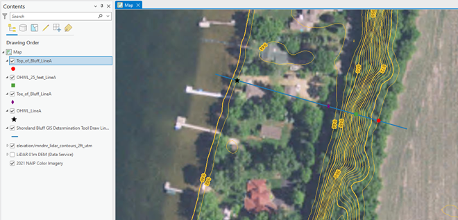
Sample site using the MNDNR Bluff GIS Determination Tool: The tool identified the top of the bluff with a red circle, toe of the bluff with a purple diamond, the OHWL with a black star and 25 feet from the OHWL with a green square.
There are two versions of the tool, one for determining a shoreland bluff (consistent with the shoreland rule bluff definition) and one for determining a Mississippi River Corridor Critical Area bluff (consistent with the MRCCA rule bluff definition).
The tool does not replace the value of a field survey, but it can help property owners understand bluffs and how to plan for development.
The tool and a step-by-step guide for downloading and using the tool can be found at Minnesota Geospatial Commons - MNGEO.
Upcoming dates and topics:
-
12/8/2025 (Mon), 1-2 p.m.: Floodplain Management Basics Register
-
12/15/2025 (Mon), 1-2 p.m.: Floodplain Administration 101 Register
-
1/7/2026 (Wed), 9:30-10:30 a.m.: FEMA Map Basics (including Letters of Map Change highlights) Register
|
|
 |
-
1/14/2026 (Wed), 9:30-10:30 a.m.: Dealing with Zone A Floodplains Register
-
1/26/2026 (Mon), 1-2 p.m.: Shoreland and Floodplain Variances Register
-
1/28/2026 (Wed), 9:30-10:30 a.m.: Accessory Structures in the Floodplain Register
|
|
 |
-
2/4/2026 (Wed), 9:30-10:30 a.m.: Grading and Non-structural Development in the Floodplain Register
-
2/11/2026 (Wed), 9:30-10:30 a.m.: FEMA Letters of Map Change (LOMCs) Register
-
2/23/2026 (Mon), 1-2 p.m.: Floodplain and Watershed Higher Standards Register
|
|
 |
-
3/4/2026 (Wed), 9:30-10:30 a.m.: Substantial Damage and Post-flood Responsibilities Register
-
3/11/2026 (Wed), 9:30-10:30 a.m.: Wells and SSTS Regulations in the Floodplain Register
-
3/23/2026 (Mon), 1-2 p.m.: Floodplain Violations and Enforcement Register
|
|
 |
Remember: Recordings of past virtual training available
To see recordings of the one-hour virtual trainings presented in recent years, and other newer on-demand virtual trainings, go to the Shoreland and river-related training page or Floodplain training page.
We had informative presentations in October on a virtual forum hosted by DNR Land Use staff, and believe the topics are of interest to many of our Water Talk Newsletter readers.
Basics of ASCE 24-24: Flood Resistant Design and Construction

Learn about ASCE 24-24, Flood Resistant Design and Construction, which sets minimum standards for buildings in flood hazard areas, often exceeding National Flood Insurance Program (NFIP) requirements. The 2024 edition introduces updated guidance for structures subject to building codes or floodplain regulations, including elevation standards based on flood design class, expanded flood hazard definitions to include the 500-year floodplain, and stricter dry floodproofing criteria. Presenter: Manny Perotin. Watch the online recording (about 50 minutes).
|
NOAA Atlas 15: National Precipitation Frequency Standard Update

See an update on NOAA Atlas 15, covering key differences from Atlas 14, project progress, and preliminary results. The presentation also details the statistical methods used to develop present-day (Volume 1) and future (Volume 2) extreme precipitation estimates. Presenter: Dr. Janel Hanrahan. Watch the online recording (about 25 minutes).
|
These videos are also available on our Floodplain Training and Education page.

Come learn in person and interact with other local officials and professionals involved in aspects of floodplain management (i.e., surveyors, consulting engineers/planners, Realtors, lenders/agents).
We plan to cover floodplain management basics and FEMA map basics, including a map reading and interpretation exercise. Other topics include floodplain administration basics, utilizing web-based flood maps and tools, dealing with nonconformities, making Substantial Improvement (SI)/Substantial Damage (SD) determinations, and community post-disaster responsibilities.
|
|
These trainings are free.
|
Registration information for both the virtual trainings and the one day in-person trainings is at our Shoreland and Floodplain Training registration page (or via a link at the top of our shoreland and floodplain training page.)
You may also use the direct registration links for the dates/locations below.
-
Mankato: Feb. 3, 2026, (Tue); 9 a.m. – 4 p.m. (8:30 registration): MnDOT District 7 Office, 2151 Bassett Drive, Mankato | Register
-
Blaine: Feb. 5, 2026 (Thu); 9 a.m. – 4 p.m. (8:30 registration): MN DPS - Homeland Security and Emergency Management, 3925 Pheasant Ridge Dr. NE, Blaine | Register
-
Waite Park: March 10, 2026 (Tue); 9 a.m. – 4 p.m. (8:30 registration): Stearns County Services Center, 3301 County Road 138, Waite Park | Register
-
Rochester: March 12, 2026 (Thu); 9 a.m. – 4 p.m. (8:30 registration): Rochester Fire Station #2, 2185 Wheelock Dr. NE, Rochester | Register
These trainings are in-person only. (There will not be a virtual option.)
Continuing Education Credits (CECs) may be obtained by Certified Floodplain Managers (CFM).
FEMA released the W-25005 memorandum on Nov. 14, 2025 extending the renewal grace period for policies that had their term end Oct. 1, 2025 to Dec. 1, 2025.
During the recent federal government shutdown it was not possible to purchase new National Flood Insurance Program (NFIP) flood insurance policies, or to renew existing policies, since the NFIP has been getting extended in concert continuing resolutions and reauthorizations, which did not occur because of the shutdown.
There is normally a 30-day grace period to get policies renewed. If the policy is not renewed during that 30-day grace period, it is treated as a new policy in the future.
This is important for the large number of policy-holders who originally purchased policies at a discount and are on a "glidepath" to the full risk rate. In 2014 Congress capped the annual increase in premiums for primary residential buildings at 18% and 25% for non-residential and non-primary residential buildings. Most of the policies that were discounted were "Preferred Risk Policies" available outside of the FEMA mapped Special Flood Hazard Areas in the past (under the past rating method), but there have been other discounts for "Newly Mapped" structures, etc.
|
By the Geomorphic Approach Team, DNR
DNR and the Hennepin County Bridge Division have partnered on a couple of road crossing projects using the Geomorphic Approach, which integrates natural channel and floodplain functions into the watercourse infrastructure project. Those successful efforts have continued in the latest collaboration on the design of the new France Avenue (County State Aid Highway 17) crossing of Nine Mile Creek.
Project design and goals
Because the project lies within a sensitive wetland complex, Hennepin County also worked closely with the Nine Mile Creek Watershed District to set culvert elevations that aligned with geomorphic recommendations and preserved existing wetland water levels.
Two eight foot by eight foot box culverts were placed in the main channel area and will carry most flows through the road crossing. Three new "floodplain culverts" were added within the floodplain, but away from the main channel. Those floodplain culverts are set higher so the water spreads out and flows through those culverts during bigger rain events.
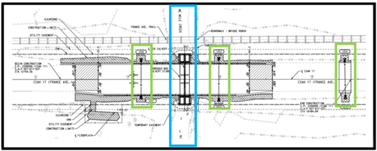
Engineering design for new France Avenue crossing of Nine Mile Creek. The blue box shows Nine Mile Creek channel and the two new 8 foot x 8 foot culverts. The green boxes show the three "floodplain culvert" locations.
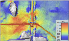
Traditional floodplain modeling is one dimensional and runs along the creek. For this project 2D modeling was used for the design. In the figure to the right the grid cells in the 2D modeling can be seen, and the coloring varies depending on the water velocity. The newer 2D models that are now available help the designers with more accurate representation of the flows during different storm frequencies.
Results
|
|
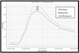
By using the floodplain conveyance design the project achieved significant reductions in channel flow while meeting floodplain regulatory requirements to not cause any increase in the 100-year flood (meeting the "No-Rise" requirement). The graph to the right shows the 15% reduction in flow for the 10-year flood.
|
|
 |
This project illustrates how applying the Geomorphic Approach enhances floodplain functions, maintains wetland hydrology, and reduces flood risk, resulting in a more resilient and ecologically compatible stream crossing.
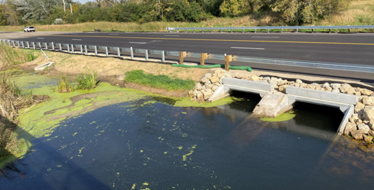
Completed France Avenue crossing of Nine Mile Creek. Note the two 8 foot by 8 foot box culverts in the main part of the channel and the smaller and higher floodplain culvert to the north (left).

The Association of State Floodplain Managers (ASFPM) is the premiere national association for all topics related to floodplain management, flood risk identification/mapping, flood risk reduction and community resilience.
The ASFPM annual conference will be relatively nearby in neighboring Wisconsin in spring 2026, so we hope to see many attendees from Minnesota.
The conference will be on the shores of Lake Michigan in Milwaukee, Wisconsin for a landmark event—ASFPM’s 50th Annual National Conference, themed: “The Fresh Coast Legacy: 50 Years of Floodplain Management.” Taking place May 31 – June 4, 2026, this milestone event celebrates five decades of progress in flood risk reduction and community resilience across the nation.
For more information
- See the ASFPM 2026 conference website for more details and to watch for updates.
- Note that the "Call For Abstracts" deadline was extended to Dec. 1, 2025 to allow all - including those affected by the federal government shutdown - to participate.
Local Scholarships
Local floodplain administrators can apply for scholarships offered by the Minnesota Association of Floodplain Managers (MnAFPM) to help offset the costs to attend the ASFPM conference - watch for updates on the scholarships anticipated to be available in January 2026 at MnAFPM.org.
|
As some of you are aware, FEMA released a Direct-to-Consumer online quoting tool on FloodSmart.gov website about a year ago. It is also referred to as their DIY quoting tool.
Overall, the tool is very user-friendly and quick to use.
Option to included elevation data added
As floodplain managers around the country began using the tool, one of the priority requests for improvement of the tool was to have the option to enter key elevations from the FEMA Elevation Certificate (EC). With more accurate elevation data the premiums are often significantly lower.
Those involved in flood risk reduction and encouraging mitigation also wanted a way to get an estimate of the flood insurance premium savings if a new home was built higher, or an older home was elevated.
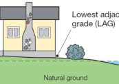
The current DIY quoting tool now asks whether there is an EC. If you say "yes" you'll be able to enter the "Lowest Adjacent Grade," "Top of Bottom Floor," "Top of the next higher floor" and "Bottom of the lowest horizontal structural member." If one of those choices is not applicable, it will be grayed out. The tool notes data will be collected from Section C of the EC only, and that Sections E and H are not yet supported.
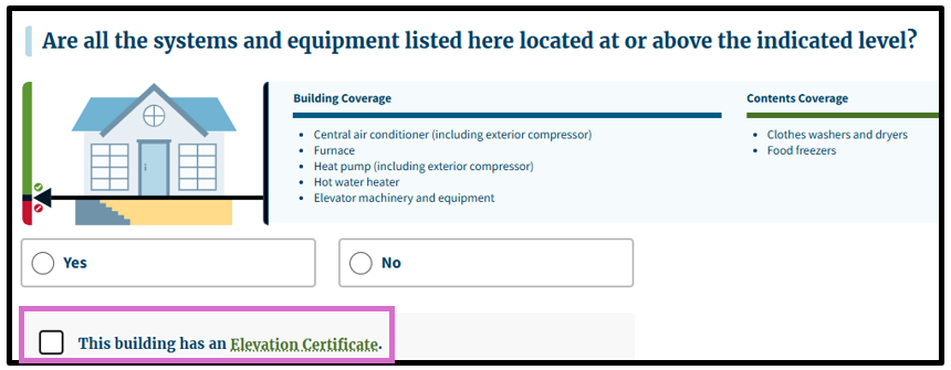
The page with the step in the DIY quoting tool when it asks where machinery and equipment are located now has a spot to note "This building has an Elevation Certificate." See within the purple box above.
Type of information needed before using DIY quoting tool
Before trying out the tool, you'll need some specific information. Most of it will be easily answered by the home/building owner, but FEMA has links for more details on the choices for most steps. The information you will likely need to look up includes:
-
Date the house/building was constructed. You should be able to find the year of construction in the county or community records, or your purchase records, but may need to approximate the month and date. (Determining whether the house was built before the first FEMA Flood Insurance Rate Map (FIRM) for that site, and whether the building is "Pre-FIRM" is one of the rating factors.)
-
Square footage of the house/building. This will also be available in the county or community records, and is usually shown in the online county records.
Example of data entry steps in FEMA's DIY quoting tool. At the building type step the homeowner picks their building type.
For additional information
The National Flood Insurance Program (NFIP) has now had over 30 extensions since the last five-year extension that expired Sept. 30, 2017. The latest extension expired Sept. 30, 2025, and the program was lapsed for the same 43 day period as the federal government shutdown. The NFIP’s authorization has now been extended to Jan. 30, 2026.
FEMA's Congressional Reauthorization for the NFIP page should have the latest updates soon (but they are not there yet). FEMA reports that they and Congress have never failed to honor the flood insurance contracts in place with NFIP policyholders. Should the NFIP’s authorization lapse, FEMA would still have authority to ensure the payment of valid flood claims with available funds.
|
|
Should the authorization lapse again, FEMA would stop selling and renewing policies for millions of properties in communities across the nation. Nationwide, the National Association of Realtors estimated in 2017 that a lapse might impact approximately 40,000 home sale closings per month.
|
|
 |

Have a tricky floodplain management situation? Want to get the latest timing for FEMA map updates?
Talk with FEMA and DNR Floodplain Program representatives during monthly virtual Minnesota Floodplain Management Office Hours. Hours are 10-11 a.m., typically on the fourth Thursday of the month (but a few are adjusted to avoid holidays, etc.).
Upcoming monthly hours (Note: all are 10 a.m. - 11 a.m. Central Time)
Where: Teams. No registration is required. Select a date to see a Teams meeting and join us.
These office hour dates and links are also available on the DNR Floodplain Training and Education page.
|
Important Dates to Note:
(since September 2025 Water Talk and upcoming in next couple months)
|
|
 |
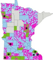
Preliminary Maps
- Murray Countywide - Sept. 15, 2025
- Aitkin Countywide - Sept. 30, 2025
Local Officials Meetings and Open Houses
- Wadena Countywide Discovery Kickoff @ Wadena - Dec. 2025/Early 2026 (to be rescheduled now that federal shutdown has ended)
- Anoka Countywide (outside Mississippi HUC8) Kickoff - Dec. 2025/Jan. 2026
- Rock County Revised Prelims Flood Risk Review - Jan./Feb. 2026
- Dodge County Better Data LOMR Flood Risk Review - Dec. 2025/Jan. 2026
- Twin Cities HUC-8 Flood Risk Review (Capitol Region, Ramsey Washington, South Washington, and Vadnais Lakes) - Jan./Feb. 2026
- Twin Cities HUC-8 Flood Risk Review (Coon Creek) - Jan./Feb. 2026
- Twin Cities HUC-8 Flood Risk Review (Rice Creek) – Jan./Feb. 2026
90-Day Appeal Periods
None
Letters of Final Determination (LFDs)
- Olmsted Countywide (Rochester Levee) - Dec. 2025/Jan. 2026? (to be rescheduled now that federal shutdown has ended)
- Wabasha Countywide - Dec. 2025/Jan. 2026? (to be rescheduled now that federal shutdown has ended)
Effective (Six months after LFD date)
None
Additional Map Update Information:
|