New on Sept. 3, 2025! The National Weather Service (NWS), a part of NOAA, has expanded their Flood Inundation Real-time Mapping to the southern portion of MN.
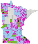
Where is the Flood Inundation Mapping (FIM) available in MN?
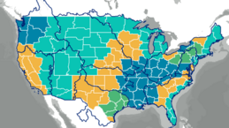
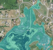
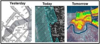
The gold area in the US map shows where the Flood Inundation Map (FIM) services were recently added. The areas in teal, including the northern half of Minnesota, are anticipated to have the services available in about a year.
The new service area in Minnesota includes Lac qui Parle, Swift, Stevens, Douglas, Todd, Morrison, Mille Lacs, Kanabec, and Chisago counties on the northern edge, and all counties to the south of that line.
How to see the Flood Inundation Mapping (FIM)
Go to the NOAA/NWS National Water Prediction Service site. On the right-side layers scroll down to see “Flood Inundation” and click the box next to "Enabled.” (Note: a bit lower in the layer options is “Administrative Boundaries,” where you can turn on county boundaries.)
When you turn on the enabled box you get a splash screen about the new Flood Inundation Mapping being experimental. You’ll also see a red boundary line at the north end of where the FIM is available.
Expand the Flood Inundation section and there will be a "Services are Experimental" note and a “more information” link to a two page document explaining the service options. Zoom in and look for the blue Flood Inundation layer in areas where the gages (or forecasts for the next five days) are at action level (yellow) or higher (Minor flood – orange; moderate flood – red; major flood – purplish). Note there is an opacity bar to adjust the transparency. Also note the map background options at the top of the layers bar. You’ll likely want the satellite option when zoomed in.
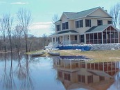
The example below shows the FIM based on forecasted levels in Vermont during a period of major flooding in July 2023.
The FIM adds a helpful tool for local officials, including emergency managers and emergency responders, to better prepare for needed response to anticipated flooding. Citizens can better educate themselves on their flooding risks and need to prepare for flooding or possible evacuation.
|
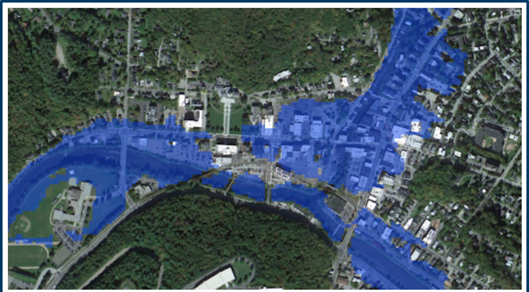 Example of National Weather Service's Flood Inundation Mapping over Montpelier, VT along the Winooski River (including its North Branch) in July 2023
How do I get more details?
|
Join us to learn about native plants with a focus on pollinators in Native Plants and Pollinators.
In this recording of a recent forum for local officials, three speakers discuss the topics: Native Plantings for Pollinators, Pollinator Conservation in Minnesota, and Carlton SWCD – A Pollinator Powerhouse!
|
|
 |
The DNR has published “The Groundwater Atlas of Isanti County.” It covers groundwater flow, groundwater chemistry and the pollution sensitivity of aquifers, expanding on the geologic atlas previously produced by the Minnesota Geological Survey.
Groundwater atlases help identify viable drinking water sources, support sustainability, guide well and septic system construction decisions, inform wellhead protection efforts for public water supplies, highlight regional recharge and groundwater movement, and assess pollution sensitivity and possible contaminant migration.
 How to See the Atlas
The atlas is available:
-
In print: Copies can be purchased online.
For more information
Partial funding for the groundwater atlas project is provided by the Minnesota Environment and Natural Resources Trust Fund and the Clean Water Fund. |
|
 |
Upcoming dates and topics:
-
10/1/2025 (Wed), 9:30-10:30 a.m.: Introduction to Flood Inundation Real-time Mapping Register
-
12/8/2025 (Mon), 1-2 p.m.: Floodplain Management Basics Register
-
12/15/2025 (Mon), 1-2 p.m.: Floodplain Administration 101 Register
|
|
 |
-
1/7/2026 (Wed), 9:30-10:30 a.m.: FEMA Map Basics (including Letters of Map Change highlights) Register
-
1/14/2026 (Wed), 9:30-10:30 a.m.: Dealing with Zone A Floodplains Register
-
1/26/2026 (Mon), 1-2 p.m.: Shoreland and Floodplain Variances Register
-
1/28/2026 (Wed), 9:30-10:30 a.m.: Accessory Structures in the Floodplain Register
|
|
 |
-
2/4/2026 (Wed), 9:30-10:30 a.m.: Grading and Non-structural Development in the Floodplain Register
-
2/11/2026 (Wed), 9:30-10:30 a.m.: FEMA Letters of Map Change (LOMCs) Register
-
2/23/2026 (Mon), 1-2 p.m.: Floodplain and Watershed Higher Standards Register
|
|
 |
-
3/4/2026 (Wed), 9:30-10:30 a.m.: Substantial Damage and Post-flood Responsibilities Register
-
3/11/2026 (Wed), 9:30-10:30 a.m.: Wells and SSTS Regulations in the Floodplain Register
-
3/23/2026 (Mon), 1-2 p.m.: Floodplain Violations and Enforcement Register
|
|
 |
Remember: Recordings of past virtual training available
To see recordings of the one-hour virtual trainings presented in recent years, and other newer on-demand virtual trainings, go to the Shoreland and river-related training page or Floodplain training page.
By Dan Miller, Water Use Specialist, Minnesota Department of Natural Resources
AI-driven growth in the development of new data centers means increased demand for water. Data centers typically use large amounts of water for cooling—sometimes as much as a small city.
New Laws
The 2025 Minnesota State Legislature passed two laws during the session that address data center developments. They allow and, in some cases, require the DNR to engage with data center developers early in the planning process and implement permit requirements to protect water availability and ensure sustainability of water resources.
The first section in Minn. Stat. 103G.265 subd. 5 states the DNR may engage with a proposed data center proposer for projects that will use more than 100 million gallons of water per year before they submit a water appropriation permit application or amendment request. The law allows the DNR to ask the proposed data center project owner and/or consultant for information that will help determine whether the potential source of water could sustainably provide for the project and other uses.
Information Required for Application
The law allows the DNR to request the following information from a proposed data center project prior to the submittal of a water appropriation permit application:
- The project’s estimated water use
- The likely source of water
- Water quality or temperature requirements
- A description of the project
- Additional information needed to assess the ability of a source of water to meet the needs of the data center
DNR Review - Timing/Conditions Added

The DNR is required to respond in writing after evaluating the information supplied by the project proposer. The pre-application process does not supplant the preliminary well construction assessment or permit application/amendments requirements. It also does not limit the DNR from requesting any additional information to make a decision about water sustainability.
The second change to Minnesota Statute requires the DNR to add permit conditions to existing or new water appropriation permits for data center projects where use will exceed more than 100 million gallons of water per year. (Minn. Stat. 103G.271 subd. 5b.). Conditions applied to a permit may require that water conservation practices are implemented, that the proposed use is sustainable, and that any concerns related to public health, safety and welfare are addressed.
|
The statute requires the DNR to ensure:
- Public health, safety and welfare are adequately protected
- Water conservation and efficiency measures are considered (i.e., water recycling, water efficient practices and fixtures, installing closed-loop systems, and supporting water restoration and replenishment in local watersheds, etc.)
- Water use conflicts are addressed, as necessary
- Testing is performed as necessary, to understand limitations and/or availability of the water source
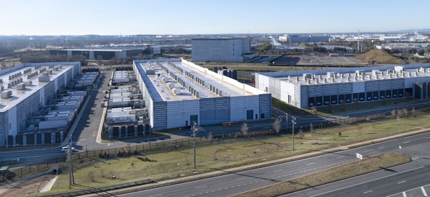 Drone view of data center. Source: Getty Images
Coordination with Minnesota First Stop Program
Last, new language in statute requires the DNR (and other state agencies) to refer a proposed data center development to the Minnesota Business First Stop Program administered by the Department of Employment and Economic Development. Minnesota Business First Stop assists new and existing companies looking to develop or expand in the state with understanding regulatory processes and procedures to make their business growth process as smooth as possible.
The DNR is required to balance competing management objectives that include both the development and protection of Minnesota’s water resources. Minnesota law also requires the DNR to manage water resources for current and future generations. This includes domestic supplies, agriculture, fish and wildlife habitat, recreation, power generation and, in some cases, navigation.
If you have any questions about the new data center-related laws as they pertain to water appropriations, please contact your local DNR area hydrologist or Dan Miller, DNR water use specialist (651-259-5731).

The Minnesota Association of Floodplain Managers (MNAFPM) annual conference will be held Nov. 12-14, 2025, in St. Cloud.
You don't want to miss all the great presentations, workshops and opportunities to learn from each other!
Schedule
- Nov. 12, 2025: Trainings, field tour, kickoff, and social
- Nov. 13, 2025: Main conference day
- Nov. 14, 2025: Certified Floodplain Manager (CFM) exam (requires separate registration with Association of State Floodplain Managers at their CFM "Getting Certified" page)
Registration
Go to the MnAFPM conference registration page to register and see links to other conference details.
Register by Oct. 12 to get the Early Bird discount for the conference registration and field tour!
Note to Minnesota local government staff: Watch for details about scholarships to attend the conference.
See MnAFPM website for more information.
|

Have a tricky floodplain management situation? Want to get the latest timing for FEMA map updates?
Talk with FEMA and DNR Floodplain Program representatives during monthly virtual Minnesota Floodplain Management Office Hours. Hours are 10-11 a.m., typically on the fourth Thursday of the month (but a few are adjusted to avoid holidays, etc.).
Upcoming monthly hours (Note: all are 10 a.m. - 11 a.m. Central Time)
Where: Teams. No registration is required. Select a date to see a Teams meeting and join us.
These office hour dates and links are also available on the DNR Floodplain Training and Education page.
|
Important Dates to Note:
(since August 2025 Water Talk and upcoming in next couple months)
|
|
 |
Preliminary Maps
- Murray Countywide - Sept. 15, 2025
- Aitkin Countywide - Sept. 30, 2025
Local Officials Meetings and Open Houses
- Wadena Countywide Discovery Kickoff @ Wadena - Early Nov. 2025
- Anoka Countywide (outside Mississippi HUC8) Kickoff - Nov./Dec. 2025
- Rock County Revised Prelims Flood Risk Review - Nov./Dec. 2025
- Dodge County Better Data LOMR Flood Risk Review - Nov./Dec. 2025
- Twin Cities HUC-8 Flood Risk Review (Capitol Region, Ramsey Washington, South Washington, and Vadnais Lakes) - Nov./Dec. 2025
- Twin Cities HUC-8 Flood Risk Review (Coon Creek) - Jan./Feb. 2026
- Twin Cities HUC-8 Flood Risk Review (Rice Creek) – Jan./Feb. 2026
90-Day Appeal Periods
None
Letters of Final Determination (LFDs)
- Olmsted Countywide (Rochester Levee) - Oct. 15, 2025 (anticipated)
- Wabasha Countywide - Dec. 2025/Jan. 2026
Effective (Six months after LFD date)
None
Additional Map Update Information:
|