Fall is a great time to plant native perennials that benefit our Minnesota pollinators. The following are some resources addressing questions we often hear.
How do I choose plants that will work in my location?
Several organizations and agencies have great overall sites that cover selecting plants, planting hints, and much more:
|
If you are on a shoreline, a couple newer resources:
Where can I get native plants/seeds?
How do I get more guidance?
Check with your city, county and/or watershed district. Many communities, county Soil and Water Conservation Districts (SWCDs) and watershed organizations have free trainings, staff who can visit your site and give guidance, and some even have cost-share grants. Many also have great newsletters, and you can subscribe to your county SWCD or watershed's newsletter to see helpful announcements and updates.
|
By Wes Saunders-Pearce, DNR, Public Waters Inventory Update Hydrologist
In 2024, the Minnesota Legislature enacted Minn. Stat. § 103G.201 (f) which directed the DNR to update the Public Waters Inventory (PWI)—a critical tool for identifying lakes, wetlands and streams that meet Minnesota’s legal definition of public waters.
The PWI was created by the DNR in the 1980s and remains a reliable and robust tool in protecting water resources across the state. In 2024, the legislature revised statute to clarify that public waters are defined by law, not by whether they appear on the PWI. As a result, the DNR is updating the inventory by 2032 to ensure it accurately reflects current legal definitions.
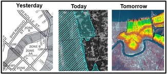
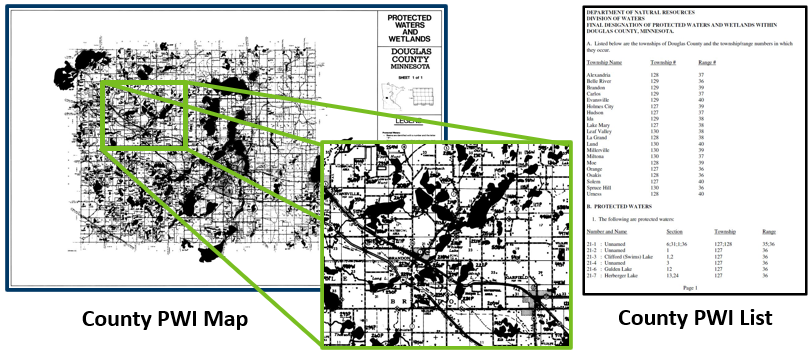 Example of Public Waters Inventory (PWI) map and list from the 1980s
Update process
The project will proceed county-by-county, with the goal of completing an average of 12 counties a year. The DNR plans to have one county underway in each of DNR’s four administrative regions at any given time.
Counties will be updated on a quasi-alphabetical basis, with adjustment as needed to defer areas with intricate topics such as ongoing trout stream designations. This approach ensures geographic representation and maintains a balance of the resources involved.
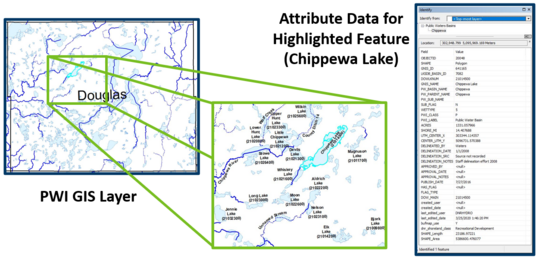 Example of Public Waters Inventory (PWI) map and list using more modern GIS tools
The PWI Update Project is a targeted effort to make corrections to the inventory and is not a re-inventory of the state’s public waters. Counties will be notified by letter prior to the work commencing. As preliminary corrections are provided for each county, there will be opportunity for review, questions and comments. Any comments received will be considered prior to finalization of PWI corrections for that county.
The project will support water resource protection by helping landowners, agencies and local governments better understand and manage water resources. The project will foster improved compliance with state laws, including Minnesota’s Buffer Law, which requires public waters to have vegetative buffers to protect water quality. (See the Buffer Mapping Project page for more details on that mapping effort.)
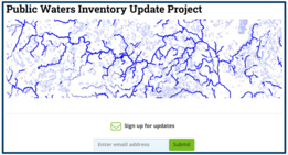
More information, including a PWI Update Project fact sheet and link to sign up for GovDelivery updates, is available on the project webpage.
|
This article is excerpted from the University of Minnesota, St. Anthony Falls Laboratory (SAFL) webpage Characterizing powerboat hydrodynamics and their impacts on the water column and lakebed
The University of Minnesota's recent study (published July 2025) focused on characterizing the hydrodynamic phenomena produced by a moving powerboat and investigating the impacts on the water column beneath the boat and at the lakebed.
The motivation for this field-based research study was the need to better understand the environmental impacts within the water column and at the lakebed as different types of recreational powerboats traverse under their typical modes of operation. The objectives of the study were to: 1) clarify and define the various hydrodynamic phenomena that are created by a recreational powerboat in motion, and how these phenomena vary with water depth and mode of operation, 2) investigate the depth of penetration and duration of emission gases (e.g., engine exhaust bubbles), 3) investigate the water column velocities and depth of penetration of the bow, stern, and transverse waves and their potential to resuspend lakebed sediment, 4) Investigate the propeller wash velocity and depth of penetration, and the potential to resuspend lakebed sediment, 5) investigate the effects of repeated boat passage on thermal stratification and mixing in the water column, 6) capture underwater and aerial video of the hydrodynamic phenomena and any subsequent impacts (e.g., sediment resuspension).
This study generated a wealth of data that the researchers used to develop recommendations on the minimum operational depth that recreational powerboats, under typical modes of operation, should maintain to minimize impacts to the lakebed.
The UMN SAFL research team includes lead researchers Andy Riesgraf and Jeff Marr, plus William Herb, Jessica Kozarek and Matt Lueker.
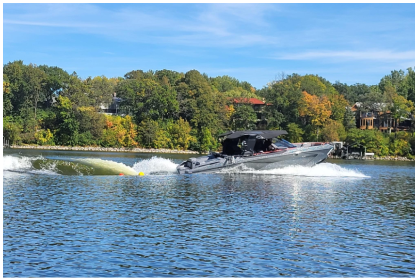 Credit: University of Minnesota St. Anthony Falls Laboratory (SAFL)
Recommendations from the study
To minimize impacts to the lakebed, the study authors provide the following depth recommendations for recreational powerboats operating in their typical modes:
-
Recommended depth of operation for planing mode (cruising). Recreational boats, like the ones studied in this project, should operate in 10 feet of water or greater when planing to minimize impacts on the lakebed.
-
Recommended depth of operation of non-wakeboats and wakeboats in displacement mode (leisure cruising). Recreational boats, like the ones studied in this project, should operate in 10 feet of water or greater when in sustained displacement mode to minimize impacts on the lakebed.
-
Recommended depth of operation for wakeboats in semi-displacement mode (surfing). Wakeboats should operate in 20 feet of water or greater when in semi-displacement mode to minimize impacts to the lake bottom.
For more information on the 2025 study
Local media stories about the 2025 study
Many local and neighboring state media sources have done segments or articles about this study and interviewed wakesurfing enthusiasts, lakeshore owners and others with varying views on wakesurfing. Here are Twin Cities media examples.
By Dan Miller, Water Use Specialist, Minnesota Department of Natural Resources
The DNR is required to balance competing management objectives that include both the development and protection of Minnesota’s water resources. Minnesota law also requires the DNR to manage water resources for current and future generations. This includes domestic supplies, agriculture, fish and wildlife habitat, recreation, power generation and, in some cases, navigation.
DNR water appropriation permit application and water use reporting fees will be increasing on January 1, 2026. The Minnesota State Legislature approved the fee increases during the 2025 legislative session. The permit application fee was last changed in 2005 from $75 per permit to $150. The annual water use reporting fees were last increased in 2008.
The fee increases support the changing demands on water resources and the need for the DNR to review permit applications, conduct technical analyses and manage water supply data across the state.
Any new permit applications, amendment requests or transfers will be required to pay $600 per permit application, amendment request or transfer. The water use reporting fee schedule will increase as well. Most permit holders use less than 50 million gallons (MG) per year. The fee for that amount will increase from $140 to $200 per permit.
|
What will the DNR do with the increase in fees?
It will take some time for the new fees collected to be realized in program improvements and catch up with the accumulated work, but we expect the fee increases to support:
- Technical review and analyses of new applications and existing permits, with increasing demands for the available water.
- Reducing the backlog in permit applications requiring technical review and analysis for more complex project proposals and applications.
- DNR compliance efforts with existing permit terms and conditions in areas with limited water availability and increasing demands for water resources.
- Improved understanding of aquifers across the state and sharing this information with existing permit holders and new applicants.
When do the new fees take effect?
New water appropriation permit applications, amendment requests or permit transfers on or after January 1, 2026, will be subject to the new application fee of $600.
The new water use fee structure will be applied to water appropriation and use during calendar year 2026 and beyond (reports due February 15, 2027). Calendar year 2025 water use will still be subject to the current fees and rate schedule.
Any permit holders reporting water use during calendar year 2026 will be required to pay the new fees by February 15, 2027.
Rates for water use reported annually (Minnesota DNR, Effective Jan. 1, 2026)
|
Volume Appropriated
|
Existing fee for each permit
|
New fee for each permit
|
|
0 to 50 million gallons
|
$140 minimum fee
|
$200 minimum fee
|
|
50 to 100 million gallons
|
$3.50 for each million
|
$6.00 for each million
|
|
100 to 150 million gallons
|
$4.00 for each million
|
$7.00 for each million
|
|
150 to 200 million gallons
|
$4.50 for each million
|
$8.00 for each million
|
|
200 to 250 million gallons
|
$5.00 for each million
|
$9.00 for each million
|
|
250 to 300 million gallons
|
$5.50 for each million
|
$10.00 for each million
|
|
300 to 350 million gallons
|
$6.00 for each million
|
$11.00 for each million
|
|
350 to 400 million gallons
|
$6.50 for each million
|
$12.00 for each million
|
|
400 to 450 million gallons
|
$7.00 for each million
|
$13.00 for each million
|
|
450 to 500 million gallons
|
$7.50 for each million
|
$14.00 for each million
|
|
Above 500 million gallons
|
$8.00 for each million
|
$15.00 for each million
|
Additionally, there are increases in the following categories of permit fees:
- The fee for a city of the first class (i.e., more than 100,000 people) increases from $250,000 per year to $325,000 per year.
- For an entity holding three or fewer permits, the maximum total annual water use fee is now $75,000.
- For an entity holding four or five permits, the maximum fee is now $125,000.
- For an entity holding more than five permits the maximum fee is now $400,000.
If you have any questions about the new permit application and water use reporting fees, please contact DNR Water Regulations Unit Supervisor Tom Hovey (651-259-5654).
The Minnesota Association of Floodplain Managers (MNAFPM) annual conference will be held Nov. 12-15, 2024, in St. Cloud.
You don't want to miss all the great presentations, workshops and opportunities to learn from each other!
Schedule
- Nov. 12, 2025: Trainings, field tour, kickoff, and social
- Nov. 13, 2025: Main conference day
- Nov. 14, 2025: Certified Floodplain Manager (CFM) exam (requires separate registration with Association of State Floodplain Managers at their CFM page)
Registration
Go to the MnAFPM conference registration page to register and see links to other conference details.
Register by Oct. 12 to get the Early Bird discount for the conference registration and field tour!
Note to Minnesota local government staff: Watch for details about scholarships to attend the conference.
See MnAFPM website for more information.
|

Have a tricky floodplain management situation? Want to get the latest timing for FEMA map updates?
Talk with FEMA and DNR Floodplain Program representatives during monthly virtual Minnesota Floodplain Management Office Hours. Hours are 10-11 a.m., typically on the fourth Thursday of the month (but a few are adjusted to avoid holidays, etc.).
Upcoming monthly hours (Note: all are 10 a.m. - 11 a.m. Central Time)
Where: Teams. No registration is required. Select a date to see a Teams meeting and join us.
These office hour dates and links are also available on the DNR Floodplain Training and Education page.
|
Important Dates to Note:
(since June 2025 Water Talk and upcoming in next couple months)
|
|
 |
Preliminary Maps
- Murray Countywide - Sept. 15, 2025 (anticipated)
- Aitkin Countywide - Sept. 30, 2025 (anticipated)
Local Officials Meetings and Open Houses
- Wadena Countywide Discovery Kickoff - Sept. 2025
- Anoka Countywide (outside Mississippi HUC8) Kickoff - Sept./Oct. 2025
- Dodge County Better Data LOMR Flood Risk Review - Sept./Oct. 2025
- Rock County Revised Prelims Flood Risk Review - Sept./Oct. 2025
- Twin Cities HUC-8 Flood Risk Review (Capitol Region, South Washington, and Vadnais Lakes) - Sept./Oct. 2025
- Twin Cities HUC-8 Flood Risk Review (Coon Creek) - Sept./Oct. 2025
- Twin Cities HUC-8 Flood Risk Review (West Mississippi & Mississippi River) - Sept./Oct. 2025
- Twin Cities HUC-8 Flood Risk Review (Rice Creek) – Sept./Oct. 2025
90-Day Appeal Periods
None
Letters of Final Determination (LFDs)
- Olmsted Countywide (Rochester Levee) - Oct. 2025
- Wabasha Countywide - Nov. 2025
Effective (Six months after LFD date)
None
Additional Map Update Information:
|