It's spring and many of us are thinking about planting projects in our yards. Have you been thinking about converting a portion of your lawn to a rain garden, native garden area, or bee-friendly lawn? Do you have shoreline where you could restore a more natural buffer?
It's worth checking with your community, watershed district or county Soil and Water Conservation (SWCD). They often have helpful resources, and may offer classes or have staff who can give guidance. Some even provide cost-share funds to do native gardens or "rain gardens."
We have a few DNR resources in the article below about riprap (and alternatives). In addition, a sampling of some other resources include:
|
Please complete our 2025-2026 DNR Floodplain and Shoreland Training Survey
The trainings offered by DNR's floodplain and shoreland management staff are targeted at staff and officials with local governments, watersheds, surveyors, consulting planners and engineers, and others involved in projects involving land use. Realtors, lenders and insurance agents may also be interested in many of the trainings we offer. The trainings are open to all.
We’d like your input on what topics are helpful and/or of interest! We’d also like input on where and when to have the in-person trainings.
- What topics would you like to see us offer for the virtual trainings? (Note that most of the virtual trainings are an hour, but some topics might need to be a bit longer.)
- Are you interested in attending one of the in-person training workshops? If so, what locations and time of the year is best?

We had been doing 4-6 one day workshops annually before COVID, and have returned to offering a few each year.
The trainings have been held around the state in past years. Where should we host trainings over the next couple years?
|
How to give input on future trainings:
- Complete the 2025-2026 DNR Floodplain and Shoreland Training Survey. Feel free to share this link with others.
- Email floodplain.dnr@state.mn.us directly with input on training topics or our in-person trainings. We've also starting doing shorter training videos on FAQ, and welcome ideas on 5-10 minute video ideas related to floodplain and shoreland management.
One of the most common questions DNR Ecological and Water Resources field staff and the DNR Information Center staff receive is about doing riprap and related "shoreline improvement" projects.
When is a permit required for a riprap project?
The short answer is - in most cases!
A permit can be required by the DNR, the zoning authority (i.e., city, county or township) and/or the watershed district. However, homeowners or contractors often selectively read the list of conditions to qualify for the "no permit required" option, decide a DNR permit is not mandatory, and then mistakenly think no permit is needed.
Two common oversights occur:
- When reviewing the DNR conditions, they note they meet one or two of the conditions, but overlook that they must meet all the conditions, especially the critical requirement that there is a demonstrated need to stop existing erosion or to restore an eroded shoreline.
- They overlook that even if a DNR permit is not required, a permit from the zoning authority or watershed district is usually required.
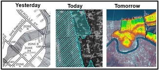
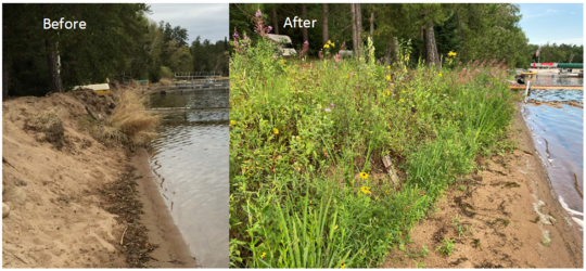 Many sites where riprap is proposed don't have a demonstrated need to stop erosion with riprap. This before and after shows the alternative of a natural vegetation buffer.
When are permits required from the zoning authority?
-
Within a FEMA mapped floodplain - Riprap is "development," as defined in local floodplain management ordinances (and federal regulations), and requires a permit (unless DNR issues a permit for the same project).
-
Within a shoreland district - Within the Shore Impact Zone (SIZ) a permit is required for movement of 10 cubic yards or more. That 10 CY includes the net grading/movement of all material including the riprap rocks, the underlying filter material, and dirt fill and/or excavation material, etc. Most riprap projects will exceed 10 CY and require a local permit.
-
Local requirements. The zoning authority may require permits for projects, including riprap, in areas outside of the FEMA mapped floodplain and the shoreland district.
What are local zoning authorities and watersheds doing?
-
Applying local higher standards. Many counties, cities and watersheds have higher standards, and those local higher standards always apply over and above DNR or state/federal floodplain requirements. Higher local standards may include criteria for active erosion that warrants riprap and requiring vegetative buffers next to the riprap.
-
Verifying that the DNR "no permit required" conditions are met. Local shoreland ordinances require, as a condition of land alteration permit approval, that any alterations or riprap below the OHWL must first be authorized by the DNR.
-
Meet floodplain regulations. If the site is within a mapped floodway, a "No Rise" analysis is required to verify the flood elevations are not being increased more than 0.00 feet. In A Zones and AE Zones without a floodway an "allowable rise" analysis to show a rise of no more than 0.5 feet and no increase on existing structures is required for sites on watercourses or lake areas with flow. In all locations, verify the project doesn't increase flood damage potential on neighboring properties (doesn't push more water on the neighbor).
-
Meet shoreland regulations. No removal of vegetation.
|
Example of unnecessary (likely illegal) riprap project
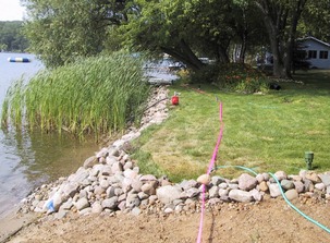
In the adjacent photo you can see many of the DNR conditions for not requiring a permit did not exist, including (but not limited to):
- Remnants of emergent vegetation mean they likely covered emergent vegetation
- The gentle slope means there was likely not a demonstrated need for riprap. If there had been erosion of the lawn, the better fix would have been to plant a natural vegetation buffer. And it's unlikely it followed the natural alignment of the shoreline
- Riprap is steeper than the maximum 3 foot horizontal to 1 foot vertical slope, and it appears filling was done behind the steeply sloped riprap
|
Encourage restoring natural shorelines
There are many good resources about the benefits of retaining and restoring natural shorelines. Start with your county Soil and Water Conservation District (SWCD), community or watershed district.
Some DNR resources:
HUD Federal Flood Risk Management Standards (FFRMS) Waiver

The Department of Housing and Urban Development issued a temporary partial waiver to the Federal Flood Risk Management Standard (FFRMS) requirements on Feb. 20, 2025. This partial waiver removes the “at least two feet” language from 24 CFR § 200.926d(c)(4), effectively removing the requirement for the lowest floor of a building in a special flood hazard area (or lowest structural member of a building in a coastal high hazard area) to be elevated two feet above the base flood elevation. All other FFRMS requirements remain in place. The temporary waiver is effective for one year and can be read here .
Note: Minnesota state regulations continue to require the lowest floor of buildings within a special flood hazard area to be elevated above the Regulatory Flood Protection Elevation, which is the base flood elevation plus one foot freeboard plus any stage increase.
|
For background on the requirements, see September 2024 Water Talk article Recent HUD Rules Require Two-Foot Freeboard to be Eligible for FHA Loans starting Jan. 1, 2025.
FEMA Federal Flood Risk Management Standards (FFRMS) Revoked

The Federal Emergency Management Agency (FEMA) March 25, 2025 press release reported the agency had revoked implementation of the Federal Flood Risk Management Standard (FFRMS) effective March 25, 2025.
The press release noted that "FFRMS Policy 206-24-005 required certain construction projects to adopt a strict standard that addressed flood risk." The policy required new construction and repairs/replacement of substantially damaged facilities (including culverts) be built in a more resilient way to avoid damage in the next flood.
The FFRMS requirements applied to FEMA direct actions and grant-funded actions under Grant Programs Directorate (GPD), Hazard Mitigation Assistance (HMA), Individual Assistance (IA) and Public Assistance (PA) involving new construction, substantial improvement and repairs to address substantial damage.
The press release reminded us that the FFRMS has no effect on FEMA's Flood Insurance Rate Maps and the National Flood Insurance Program mapping process. The FFRMS also did not affect National Flood Insurance Program premium rates or inform mandatory flood insurance purchase requirements.
For more details see the full press release.
|
For background on the requirements, see October 2024 Water Talk article FEMA Flood Risk Management Standard (FFRMS) Policy.

Have a tricky floodplain management situation? Want to get the latest timing for FEMA map updates?
Talk with FEMA and DNR Floodplain Program representatives during monthly virtual Minnesota Floodplain Management Office Hours. Hours are 10-11 a.m., typically on the fourth Thursday of the month (but a few are adjusted to avoid holidays, etc.).
Upcoming monthly hours (Note: all are 10 - 11 a.m. Central Time)
Where: Teams. No registration is required. Select a date to see a Teams meeting and join us.
These office hour dates and links are also available on the DNR Floodplain Training and Education page.
|
Important Dates to Note:
(since March 2025 Water Talk and upcoming in next couple months)
|
|
 |
Preliminary Maps
None
Local Officials Meetings and Open Houses
- Anoka Countywide (outside Mississippi HUC8) Kickoff - June/July 2025
- Becker County (outside of Ottertail HUC8) Flood Risk Review - June/July 2025
90-Day Appeal Periods
None
Letters of Final Determination (LFDs)
None
Effective (Six months after LFD date)
None
Additional Map Update Information:
|