|
Wisconsin's Center for Land Use Education (CLUE) has produced several videos over the last couple years related to shoreland zoning that we believe will be of interest.
Available videos:
Note: Any advertising that appears in conjunction with these videos is generated by the platform and not by the Minnesota Department of Natural Resources.
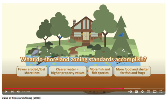 Screen shot of the "Value of Shoreland Zoning" video.
Minnesota and Wisconsin have Shoreland Management rules
Our neighbors in Wisconsin have Shoreland Management regulations that actually pre-date our Shoreland Management regulations in Minnesota by a few years. While our regulations differ in some areas, the intent remains the same - protection of our shorelines, habitat and water quality!
For more information on the Minnesota regulations, see the DNR Shoreland Management Program page
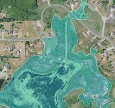
The former DNR "NWI Wetland Finder" site recently went through an update, and users will be redirected to Wetland Finder. If you were a user of the previous site, you realize how helpful the site was for initial screening of public waters and wetlands of all types. The updated site adds another layer, rare natural communities, which can be especially useful for local governments administering Minnesota's Wetland Conservation Act (WCA) and project proposers.
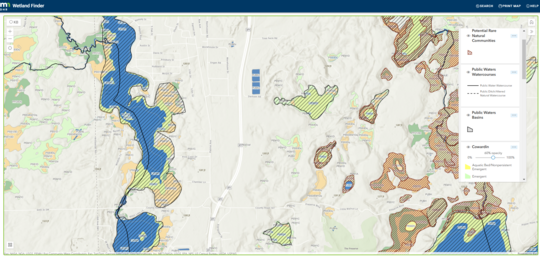 Sample screen shot of DNR Wetland Finder site showing potential rare natural communities, public water watercources and basins, and wetlands shown with Cowardian symbology
What are the updates?
- Ensured compatibility with common mobile devices.
- Created new user interface (to keep the app infrastructure modern and up to date).
- Added layers representing identified and potential rare natural communities.
-
Rare natural communities are intact, high quality native plant communities identified by the Ecological and Water Resources (EWR) Division.
- Identified rare natural communities have been nominated, considered a candidate, or designated as a rare natural community by an EWR ecologist.
- Potential rare natural communities were compiled using GIS resources, including the Minnesota Biological Survey Sites of Biodiversity Significance and the DNR Native Plant Communities. This is not a comprehensive map of potential rare natural communities because the layers that it draws upon are not comprehensive. A regional ecologist or the DNR Technical Evaluation Panel (TEP) member may request that additional mapping data be collected by a project proposer to fill a data gap, particularly if there area adjacent areas of potential rare natural communities.
- Added DNR Kittle number as ID for Public Waters Inventory Watercourses.
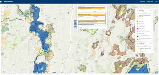 Sample screen shot of Wetland Finder showing call out window for a basin with links for contacts and more details
More details available in ID call-out box
If you select a basin, a call-out box shows information about the different wetland categories, rare natural communities status, public waters inventory basin or watercourse ID, and links to contacts for Wetland Conservation Act regulations or DNR Area Hydrologists (for public water permit requirements).
More information: If you have questions, comments, or issues related to the new viewer, contact wetlandmapping.dnr@state.mn.us.
By Ceil Strauss, DNR state floodplain manager
Many are asking about the impacts of Executive Orders by President Trump and similar actions of the new administration. How much are these impacting our floodplain management at the state and local level?
State and local regulations have not changed
Note that the state floodplain management rules have been in place since 1970 and are not changed by more recent federal actions. Floodplain ordinances have been adopted by local communities in accordance with state law, and continue to be the regulations enforced within our communities.
Recent federal actions impacting federal agencies
As always, we are in close contact with our partners at the local, state and federal levels and we are monitoring the dynamic situation in Washington. We will let communities know if and when any federal actions lead to changes to current processes related to floodplain management and mapping updates.
Examples of specific actions related to floodplain management:
- An Executive Order issued Jan. 24 established a FEMA Review Council. This Council is tasked with reviewing and recommending improvements to federal disaster assistance programs within 180 days. Note that there are some changes in FEMA organization that have been recommended for consideration in the past, including consideration of more delegation of some programs (or portions of programs) to states that demonstrate capacity/capability. We will be monitoring the commission's recommendations for potential impacts on the state and our communities.
- Current members of FEMA advisory councils, including the National Advisory Council (NAC) and Technical Mapping Advisory Council (TMAC) received notice they were dismissed. We understand there will be a new member selection process.
Again, be assured if there are updates that impact floodplain management and mapping in the state, we'll work with our partners to share that information.

Back by popular demand!
A series of FREE one-hour virtual trainings on floodplain management topics continue to be offered January through March 2025. The timing will be similar to our Winter 2023 and 2024 series, with most trainings offered 1-2 p.m. on Mondays, and 9:30-10:30 a.m. on Wednesdays.
Use the "Register" link next to each training to sign up.
You'll also be able to find the registration links and more details about each training on the DNR 2025 Shoreland and Floodplain Upcoming Live Trainings page, or via the link at the top of the DNR Shoreland and Floodplain Education and Training Center.
Remaining upcoming dates and topics:
|
-
2/3/2025 (Mon), 1-2 p.m.: Dealing with Zone A Floodplains Register
-
2/5/2025 (Wed), 9:30-10:30 a.m.: FEMA Flood Insurance Basics Register
|
|
|
|
 |
-
2/10/2025 (Mon), 1-2 p.m.: Floodplain Administration 201 (CUPs, floodproofing, etc.) Register
-
2/12/2025 (Wed), 9:30-10:30 a.m.: Floodplain and Watershed Higher Standards Register
|
|
 |
-
2/24/2025 (Mon), 1-3 p.m.: Planning and Zoning 101 (*New topic) Register
-
3/10/2024 (Mon), 1-2 p.m.: Post-flood Responsibilities and Substantial Damage Determinations Register
|
|
 |
One Continuing Education Credit (CEC) may be obtained by Certified Floodplain Managers (CFM) for each virtual training attended.
Remember: Recordings of past virtual training available
To see recordings of the one-hour virtual trainings presented in recent years, and other newer on-demand virtual trainings, go to the Shoreland and river-related training page or Floodplain training page.

Come learn in person and interact with other local officials and professionals involved in aspects of floodplain management (i.e., surveyors, consulting engineers/planners, Realtors, lenders/agents).
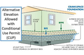
We plan to cover floodplain management basics and FEMA map basics, including a map reading and interpretation exercise. Other topics include: floodplain administration basics, utilizing web-based flood maps and tools, dealing with nonconformities, making Substantial Improvement (SI)/Substantial Damage (SD) determinations, and community post-disaster responsibilities.
These trainings are free.
|
Registration information is available via a link at the top of our training page. You may also use the direct registration links for the dates/locations below.
-
Brainerd: April 1, 2025, (Tue); 9 a.m. – 4 p.m. (8:30 registration): Crow Wing County Government Center (Land Services Building), 322 Laurel Street, Brainerd | Register
-
Cambridge (Tentative): April 2, 2025 (Wed). Details coming.
-
Apple Valley: April 9, 2025 (Wed); 9 a.m. – 4 p.m. (8:30 registration): Dakota County Western Service Center, Room 106, 14955 Galaxie Avenue, Apple Valley |Register
Continuing Education Credits (CECs) may be obtained by Certified Floodplain Managers (CFM).
The National Flood Insurance Program (NFIP) has now had over 30 extensions since the last five-year extension that expired Sept. 30, 2017. The latest extension was set to expire Dec. 20, 2024, but the NFIP’s authorization was extended to March 14, 2025.
FEMA's Congressional Reauthorization for the NFIP page should have the latest updates. FEMA reports that they and Congress have never failed to honor the flood insurance contracts in place with NFIP policyholders. Should the NFIP’s authorization lapse, FEMA would still have authority to ensure the payment of valid flood claims with available funds.
|
|
Should the authorization lapse, however, FEMA would stop selling and renewing policies for millions of properties in communities across the nation. Nationwide, the National Association of Realtors estimated in 2017 that a lapse might impact approximately 40,000 home sale closings per month.
|
|
|
 |
FEMA Region 5 staff (based in Chicago) are continuing their monthly one-hour virtual training series in 2025. They are free!
It's not too late to register for many training topics!
Upcoming "Managing your Community's Floodplain" monthly series dates and topics:
|
Note: All held 9-10 a.m. Central Time.
|
|
 |
2025 Flood Insurance Webinar Series: "From Risk to Resilience: Mastering Flood Insurance Together."
This year-long series is designed to empower insurance agents, floodplain managers, and community leaders with the knowledge and tools to navigate the National Flood Insurance Program (NFIP).
Key Details:
-
Cost: Free
-
Format: Virtual via Zoom; most are 30-minute lunch-and-learn format, but Special Sessions are 1-hour with optional Q&A session to follow.
-
Continuing Education: This series is not approved by any state licensing authority or professional organization for continuing education credits.
Training Dates and Topics:
Note: The registration links for the monthly lunch-and-learns all go to the same form. You can select the dates of interest. (You'll need to slide down in the date options to see June 26 and later dates.)
-
Feb. 20, 12:30-1:00 p.m.: Eligibility and Coverage Essentials | Register
-
March 20, 12:30-1:00 p.m.: Increased Cost of Compliance (ICC): Helping Clients Rebuild Smarter | Register
-
April 17, 12:30-1:00 p.m.: Mapping Made Simple | Register
-
April 24, 9:30-10:30 a.m.: Special Session: Introduction to Flood Insurance Through the National Flood Insurance Program | Register
- May 15, 12:30-1:00 p.m.: Navigating Claims and Supporting Disaster Survivors | Register
-
June 19, 12:30-1:00 p.m.: Elevating Flood Insurance Conversations | Register
-
June 26, 9:30-10:30 a.m.: Special Session: Increased Cost of Compliance: Leveraging the SFIP to Build Resilient Communities | Register
-
July 17, 12:30-1:00 p.m.: Marketing Flood Insurance Effectively | Register
-
Aug. 21, 12:30-1:00 p.m.: Building Resilient Communities Through Flood Insurance | Register
-
Sept. 18, 12:30-1:00 p.m.: Writing Policies for Unique Clients | Register
-
Oct. 16, 12:30-1:00 p.m.: Understanding the Claims Process | Register
-
Oct. 23, 9:30-10:30 a.m.: Special Session: Introduction to Flood Insurance Through the National Flood Insurance Program | Register
-
Nov. 20, 12:30-1:00 p.m.: Flood Insurance for a Changing World | Register
-
Dec. 19, 12:30-1:00 p.m.: Why Flood Insurance Matters | Register

Got questions about the Federal Flood Risk Management Standard or some other state or federal requirement? Have a tricky floodplain management situation?
Talk with FEMA and DNR Floodplain Program representatives during monthly virtual Minnesota Floodplain Management Office Hours. Hours are 10-11 a.m., typically on the fourth Thursday of the month (but a few are adjusted to avoid holidays, etc.).
Upcoming monthly hours (Note: all are 10 - 11 a.m. Central Time)
Where: Teams. No registration is required. Select a date to see a Teams meeting and join us.
These office hour dates and links are also available on the DNR Floodplain Training and Education page.
|
Important Dates to Note:
(since December 2024 Water Talk and upcoming in next couple months)
|
|
 |
Preliminary Maps
None
Local Officials Meetings and Open Houses
None
90-Day Appeal Periods
- Wabasha Countywide- 10/10/2024 to 1/8/2025 (For Zumbro Falls: 11/15/2024 to 2/13/2025)
Letters of Final Determination (LFDs)
None
Effective (Six months after LFD date)
- March 11, 2025 - Itasca Countywide
- March 25, 2025 - St. Louis Countywide
Additional Map Update Information:
|