Weekly drought update
Oct. 5, 2023
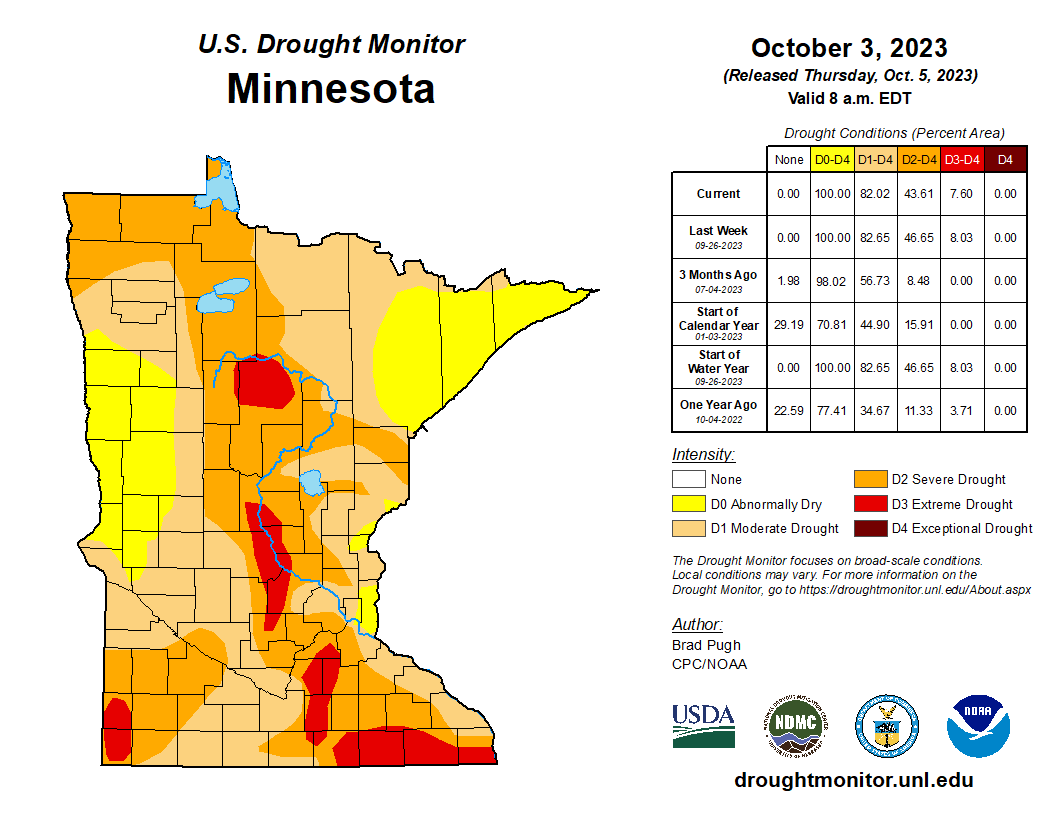
The weekly U.S. Drought Monitor map released Thursday, Oct. 5 was nearly identical to last week, with the exception of a very small amount of D1 (moderate drought) receding to D0 (abnormally dry) in east-central Minnesota.
- 18% of Minnesota is experiencing abnormally dry conditions.
- 38% of the state is in moderate drought, increased from 36% last week.
- 36% of Minnesota is in severe drought, decreased from 39% last week.
- 8% of the state is in extreme drought, unchanged from last week.
- The previously described increase in the amounts of moderate and severe drought are a reflection of improvement from decreasing coverage of extreme drought.
Statewide Drought Plan Watersheds
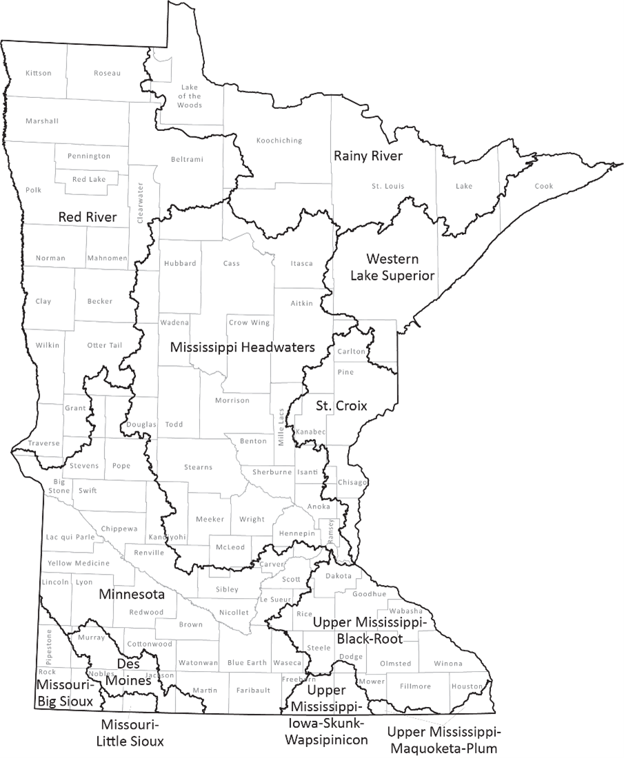
The Minnesota Statewide Drought Plan applies drought phases to the twelve river basin watersheds in the state (HUC4 level).
Drought Restrictive Phase:
- Upper Mississippi-Maquoketa-Plum (continuing)
- Upper Mississippi-Iowa-Skunk-Wapsipinicon (continuing)
- Upper Mississippi-Black-Root (continuing)
Drought Warning Phase:
- Croix (continuing)
- Mississippi Headwaters (continuing)
- Missouri-Big Sioux (continuing)
- Red River (continuing)
- Minnesota River (continuing)
Drought Watch Phase:
- Western Lake Superior (continuing)
- Rainy River (continuing)
- Des Moines River (continuing)
- Missouri-Little Sioux (continuing)
While their watershed is in the Drought Warning Phase, public water suppliers are required to implement water conservation measures, with the goal of reducing water consumption to no more than 150% of January levels. For watersheds in the Drought Restrictive Phase, public water suppliers are required to implement water conservation measures, with the goal of reducing water consumption to no more than 125% of January levels.
Drought conditions typically lead to increased irrigation for crops, lawns and athletic fields, which leads to additional strain on Minnesota’s water resources. Moderate drought (D1) is characterized by dry soil conditions, stressed crops, and lower than average river and lake levels. Severe drought (D2) is characterized by much lower-than-average river and lake levels hard ground and a higher potential for severe impacts on agriculture. Extreme drought (D3) may result in early harvest of corn and increased risk of wildfires. In exceptional drought (D4), early harvest of corn and emergency haying and grazing are typical, surface waters are near record lows and wildfires may be widespread.
Streamflow Information
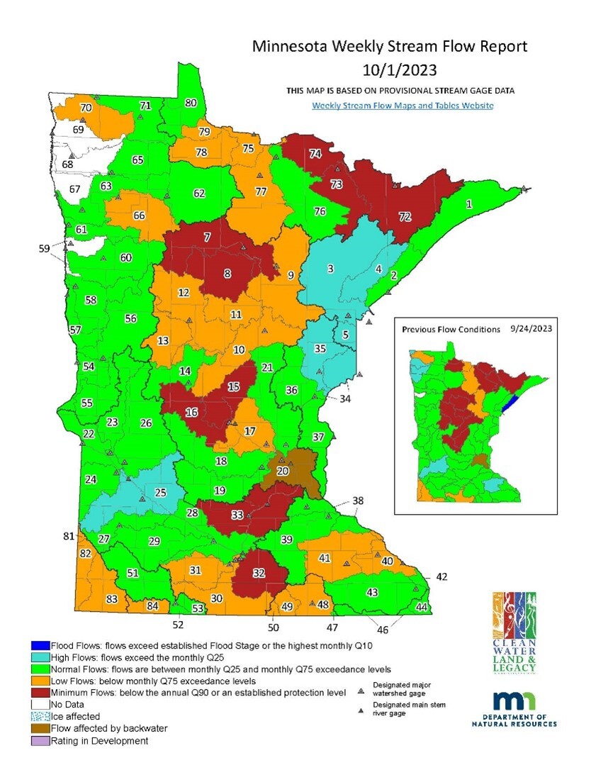
Surface water appropriations are contingent upon stream flows in the HUC8 level watersheds (as opposed to the larger HUC4 watersheds that are used for Drought Phase specification).
The low flow management plan for the Mississippi River has been in effect since July 31. The plan imposes certain restrictions on dam operators and is designed to help ensure water is available for hydropower generation, public water supply, and to protect aquatic resources downstream.
Minnesota statute requires the DNR to limit consumptive appropriations of surface water under minimum flow conditions to protect instream ecology and downstream public water supplies. Water use types considered for suspension include irrigation, dust control, sand and gravel washing, and construction non-dewatering. Permits for public drinking water are not suspended.
Nine watersheds are below the minimum flow threshold, Q90, this week. No surface water appropriation permits were suspended this week, however, 13 permits were reinstated in the St. Louis River (No. 3) and Cloquet River (No. 4) watersheds on Oct. 5 due to significantly increased stream flows. One permit will be reinstated on Friday, Oct. 6 in the Kettle River watershed (No. 35), also due to increased stream flows following significant rain over the last few weeks in the watershed area.
In Mississippi River watersheds, 143 surface water appropriation permits continue to be suspended in – Grand Rapids (No. 9), Pine River (No. 10), Crow Wing River (No. 12), Redeye River (No. 13), Mississippi River-Sartell (No. 15), Sauk River (No. 16), Mississippi River-Shakopee watershed (No. 33), Snake River (No. 36), Lower St. Croix River (No. 37), Mississippi River – Lake Pepin (No. 38), Zumbro River watershed (No. 41), Marsh River (No. 59), Two Rivers (No. 70), Rainy River – Headwaters (No. 72), Little Fork River watershed (No. 76), Big Fork River (No. 77), Rapid River (No. 78) and Rainy River-Baudette (No. 79) watersheds.
Stream flows increased above the minimum flow (Q90) in the following watersheds: Mississippi River-Grand Rapids (No. 9), Pine River (No. 10), Crow Wing River (No. 12), Redeye River (No. 13), Little Fork River (No. 76), Rapid River (No. 78) and Rainy River-Baudette (No. 79). The DNR will be reviewing data at the designated stream flow gage for each watershed to verify stream flows for consideration of permit reinstatement.
Minimum stream flows are persisting in the Mississippi River – Headwaters (No. 7), Leech Lake River (No. 8) watersheds. Although minimum stream flows persist, there are currently no surface water appropriation permits with consumptive uses eligible for temporary suspension in the Vermillion River (No. 73), Rainy River-Rainy Lake (No. 74) watersheds.
The DNR is taking the following actions:
- Communicating with permittees whose permits will be reinstated due to increased flows.
- Continuing to monitor streams where flows have reached minimums that may trigger appropriations permit suspensions.
- Monitoring streams where flows have risen above minimums that may trigger appropriations permit reinstatement.
- Monitoring precipitation and water levels.
Precipitation Forecast
Analysis
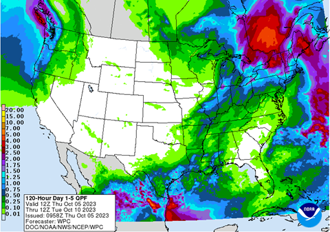
As of Oct. 5, the five-day Quantitative Precipitation Forecast produced by NOAA’s Weather Prediction Center illustrates a prediction of one one-hundredth to one-tenth of an inch of rain across most of Minnesota. Far northwestern Minnesota is predicted to get one-quarter inch. This forecast is valid from Oct. 5 to Oct. 10. For updated forecasts, see the NOAA Weather Prediction Center’s Quantitative Precipitation Forecast.
For additional information, contact:
|

