|
October 20, 2023
In this newsletter

Happy October!
We had a successful turnout at the GIS/LIS Conference in Duluth earlier this month. Also, with October comes changes in the hours of daylight, the temperature, and... we had the official retirement of our faithful support email mnitservices.dnr @state.mn.us. October 19th was its last official day of duty. We should have held a retirement party for such a servant.
How do I get GIS support?
Glad you asked. We are here to help navigate this change. Yesterday, you got an email from your regional GIS support sharing a little tip sheet that walks through the process for GIS requests. Also yesterday, Jenna Covey (MNIT DNR Chief Business Technology Officer) emailed a calendar invitation to attend an optional training session on November 1 (11:30-12:30) and shared the Minnesota HUB Service guide. This guide and optional training session will be helpful in navigating all of the other agency service requests in the Minnesota Service Hub. We're in this together!
Please join us on October 24th for the GIS User Group meeting for updates on the ArcGIS Enterprise project. If you're looking for GIS training, we officially have registration open for our November and December classes. Hope to see you at one of these events.
~ Catherine Hansen, Interim GIS Section Supervisor
|
Back to top menu
Fall ArcGIS Pro Classes Available!
Join us this fall to learn ArcGIS Pro. Three offerings include Migrating, Introduction and Editing in Pro.
Find out how to register in ELM today! For more information on course offerings and Registration Directions visit the GIS Events and Training Intranet page.
__________________________________________________________
Migrating from ArcMap to ArcGIS Pro - One-day course for ArcMap users migrating to ArcGIS Pro - $100
Learn the basic functions of ArcGIS Pro and its differences from ArcMap to start your transition.
- November 14, 2023 - Virtual Classroom
- November 29th, 2023 - In Person @ Bemidji HQ
- December 7th, 2023 - In Person @ New Ulm HQ
- December 8th, 2023 - In Person @ Grand Rapids HQ
- December 11th, 2023 - Virtual Classroom
__________________________________________________________
Introduction to ArcGIS Pro - Two-day course learning ArcGIS Pro - $200
Learn GIS with ArcGIS Pro and dive into the basics of visualization.
- November 8-9, 2023 - Virtual Classroom
- November 20th - December 1st, 2023 - Virtual Classroom
- December 14th-15th, 2023 - In Person @ Grand Rapids
- December 20th-21st, 2023 - In Person @ New Ulm
__________________________________________________________
Editing Workflows in ArcGIS Pro - One-day course learning editing workflows in ArcGIS Pro - $100
Learn how to create and edit feature and files in ArcGIS Pro.
- November 17th, 2023 - Virtual Classroom
- December 5th, 2023 - Virtual Classroom
|
Back to top menu

The NEW HUB - Submitting Service Requests
On October 19th, 2023, the old MNIT Services email MNITServices.dnr @state.mn.us STOPPPED accepting emails.
The new process for requesting ANY MNIT help is through the Minnesota Service HUB or calling 651-297-1111.
If you are looking for help from the GIS Team or other DNR divisional Business Service teams, use the DNR Application and Services Support icon on the Minnesota Service HUB. This Tipsheet walks through submitting a support request to the GIS Team.
If you have any questions about or issues with using the Minnesota Service HUB, call 651-297-1111. Additionally, check out this guide about the MNIT Enterprise Service Desk.
|
Back to top menu

2023 User Group Meetings for GIS users
Join a User Group Meeting to hear from fellow colleagues and to share the GIS work we do. All are scheduled to be virtual meetings.
Click on the user group name below to access and add the series .ics file to your calendar.
GIS User Group Meetings for ALL GIS users or anyone interested in GIS at MNDNR
4th Tuesday Quarterly, from 1pm-2pm
Oct 24 - GIS Section Project Updates
ArcGIS Pro User's Group Meetings for anyone interested in ArcGIS Pro
4th Friday Quarterly, from 1pm-2pm
November 17th (3rd Friday)
Python User Group Meetings for anyone interested in using Python
2nd Thursday Quarterly, from 1pm-2pm
Dec 14
Agendas and past meetings are available online. Please visit our web site today!
|
Back to top menu
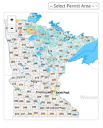
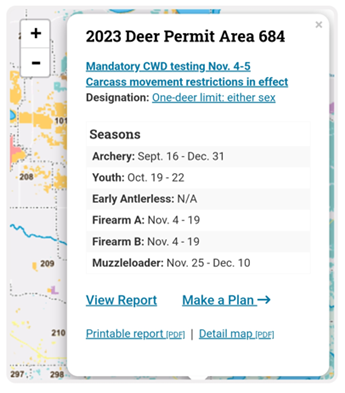
Interactive Deer Permit Area Map
Wildlife GIS and MNIT Web Team team-up to upgrade the Interactive Deer Permit Area Map.
In 2014, the Minnesota Deer Hunters Association (MDHA) Executive Director sent a letter to DNR Commissioner Landwehr to recommend some ways DNR could help foster better communication with their members, deer hunters.
One of the recommendations was to build a web interface with a “point and click” technology to access detailed Deer Permit Area (DPA) reports that would help explain information Wildlife Managers use to set hunting regulations for each DPA including harvest and hunter statistics, land cover, winter severity, public hunting access and current deer herd management objectives. In 2015, Wildlife GIS and MNIT Web Team rolled out a new interactive deer permit area map that included these detailed reports in pdf format. As DNR web users have shifted from using primarily desktop to mobile devices, a project was set forward to generate a mobile responsive html based detail report with enhanced graphics to further foster that communication with deer hunters.
|
The DPA interactive map is built on top of the Recreation Compass tiles that are ubiquitous on the DNR public website. A custom WMS service is used to overlay DPA boundaries and is paired with a point-based data service that return JSON data from DPA and DPA boundary feature classes stored in PostgreSQL/PostGIS. MapServer and MapCache are used to deliver WMS tile and data services. The client-side map itself is implemented using Leaflet – a popular web-based mapping client – and utilizes both jQuery and Underscore.js to complete the stack. The map runs equally well on both desktop and mobile devices thanks to responsive design using the Bootstrap framework.
The web-based DPA detail reports also consume JSON data derived from DPA detail data stored in PostgreSQL/PostGIS. Data are published via a Python script and refreshed hourly. Like the DPA map, the detail pages rely on Leaflet, jQuery and Underscore.js to render a page. The interactive graph elements use Apex Charts a popular web-based charting library.
Both pages rely heavily on open source components
www.mndnr.gov/deermap
|
Back to top menu
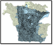
Updated Minnesota DNR Watershed Suite and Catchment Dataset Available October 31, 2023
St. Paul, Minn. – The Minnesota Department of Natural Resources (DNR) is the state agency responsible for creating and updating the official watershed map of Minnesota published in 1977. Through a detailed watershed delineation process, the map was modernized and brought into a GIS data model under the Minnesota Watershed Delineation Project (1998 - 2010). Serving as Minnesota’s authoritative watersheds, the data was published as the MN DNR Watershed Suite, a collection of watershed delineations for Minnesota ranging from catchments up to the Majors. Elements of this diverse watershed data model were extracted in 2010 to create the Minnesota portion of the U.S. Geological Survey national Watershed Boundary Dataset (WBD). With increasingly detailed input data capturing changes on the landscape, and delineation methodologies that improve how we define the hydrologic landscape, watersheds boundaries were no longer static features. Changes occurred over the next decade (2011 - 2023) by state and federal watershed data stewards working as a team to update Minnesota watershed delineations on the WBD. This team also worked with Canadian data stewards during this time under the International Join Commission (IJC) to align state, federal, and international watershed delineations.
A new 2023 update of the MN Watershed Suite is being published that incorporates all WBD updates. The revised watershed boundaries will include areas outside of Minnesota that contribute flow into the state for complete representation of drainage areas in watershed modeling.
The updated MN DNR Watershed Suite and associated metadata will be published on October 31st on DNR Quick Layers with the existing Layer name (DNR Watershed Suite) under Watersheds in the Hydrography category. To provide continued access to the Legacy watershed dataset, a new resource has already been published to the GDRS and Minnesota Geospatial Commons and is available on Quick Layers as the DNR Watershed Suite Legacy (2010-2023). The Legacy dataset will remain on the GDRS until June 30, 2024 at which point it will be removed and archived.
The MN DNR Watershed Suite will also be available from the Minnesota Geospatial Commons. You can access the MN DNR Watershed Suite at this resource on the Commons - https://gisdata.mn.gov/dataset/geos-dnr-watersheds . The metadata for the updated information will be available at the above location for reference.
The Minnesota Clean Water Fund supports the update of the Watershed Suite and the Watershed Delineation Program.
|
Back to top menu

Join the Conversation
Add yourself to the DNR GIS Community Microsoft Team today. It has been designed for any DNR employee using or interested in GIS technology. Anyone can be as active or passive in the Team as they desire.
The Community is an interactive environment for members to ask GIS related questions and collaboratively share ideas. Join to Be Informed, Get Answers to Questions, or Get Feedback on Ideas.
|
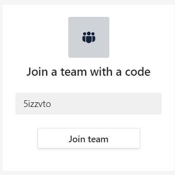
DNR employees can add themselves to the DNR GIS Community with the Team code 5izzvto.
In Teams, click on the Join or create a team button at the bottom of your list of Teams.
Type in the code 5izzvto and click Join team.
The DNR GIS Community Team is an additional communication tool to enhance (not replace) the purpose of this DNR GIS Newsletter or the GIS Section Intranet pages.
Want to know more? Check out the Team's Frequently Asked Questions.
|
Back to top menu
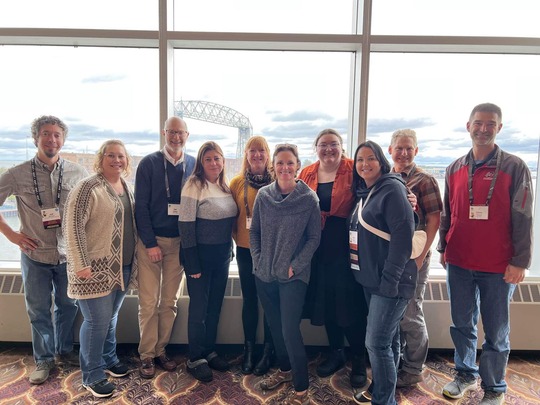
GIS Members Jeff Reinhart, Katie Rossman, Hal Watson, Sherry Ellison, Kari Geurts, Catherine Hansen, Kate Carlson, Kim Nelson, Zeb Thomas, and Chris Pouliot at the GIS LIS Consortium Annual Conference in Duluth Oct 6, 2023.
|