Weekly drought update
Sept. 14, 2023
Drought conditions intensified across Minnesota over the past week, with areas of moderate, severe, and extreme drought expanding and areas of exceptional drought persisting. The Mississippi River continues to experience low flows, although recent rain in the northern part of the state has provided some additional flow that will benefit water users that depend on the river.
The Minnesota DNR is taking a number of actions (described below), consistent with the Statewide Drought Plan and statutory water use priorities. We are also coordinating closely with other agencies and water users and communicating broadly about the importance of water conservation.
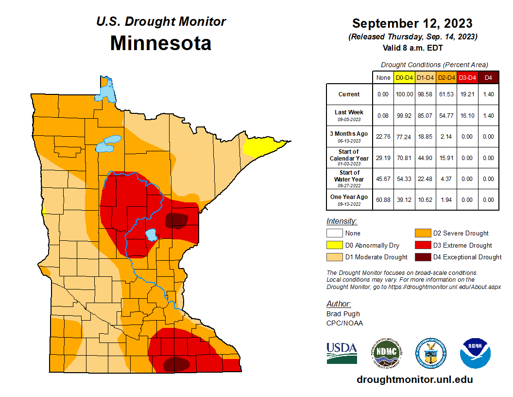
The weekly U.S. Drought Monitor map released Thursday, Sept. 14 shows that nearly all of Minnesota is experiencing some degree of drought, with most of Minnesota experiencing severe or extreme drought.
- 1% of Minnesota is experiencing abnormally dry conditions.
- 37% of the state is in moderate drought, increased from 30% last week.
- 42% of Minnesota is in severe drought, increased from 39% last week.
- 18% of the state is in extreme drought, increased from 15% last week.
- 1% of Minnesota is in exceptional drought, unchanged from last week (see special note below).
Special Note regarding Exceptional Drought
Exceptional drought is occurring in portions of Aitkin, Carlson and Pine counties in east-central Minnesota and in Freeborn and Mower counties in southeastern Minnesota. The exceptional drought in southeastern Minnesota encompasses most of the Minnesota portion of the Upper-Mississippi-Iowa-Skunk-Wapsipinicon Watershed. Exceptional drought in the east-central portion of the state is straddling three different watersheds (Mississippi Headwaters, Western Lake Superior and St. Croix).
Statewide drought plan watersheds
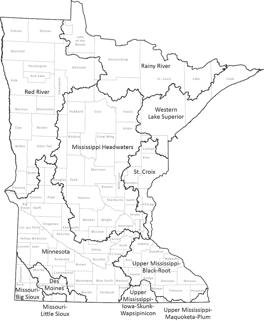
The Minnesota Statewide Drought Plan applies drought phases to the twelve river basin watersheds in the state (HUC4 level).
One additional watershed has moved to the Drought Restrictive Phase, as prescribed in the Statewide Drought Plan:
- Upper Mississippi-Black-Root
Two watersheds remain in the Drought Restrictive Phase:
- Upper Mississippi-Maquoketa-Plum
-
Upper Mississippi-Iowa-Skunk-Wapsipinicon
One additional watershed has moved to the Drought Warning Phase:
Four watersheds remain in the Drought Warning Phase:
- Croix
- Mississippi Headwaters
- Missouri-Big Sioux
- Western Lake Superior
Four watersheds remain in the Drought Watch Phase:
- Rainy River
- Minnesota Basin
- Des Moines River
- Missouri-Little Sioux
While their watershed is in the Drought Warning Phase, public water suppliers are required to implement water conservation measures, with the goal of reducing water consumption to no more than 150% of January levels. For watersheds in the Drought Restrictive Phase, public water suppliers are required to implement water conservation measures, with the goal of reducing water consumption to no more than 125% of January levels.
Drought conditions typically lead to increased irrigation for crops, lawns and athletic fields, which leads to additional strain on Minnesota’s water resources. Moderate drought (D1) is characterized by dry soil conditions, stressed crops, and lower than average river and lake levels. Severe drought (D2) is characterized by much lower-than-average river and lake levels hard ground and a higher potential for severe impacts on agriculture. Extreme drought (D3) may result in early harvest of corn and increased risk of wildfires. In exceptional drought (D4), early harvest of corn and emergency haying and grazing are typical, surface waters are near record lows and wildfires may be widespread.
Streamflow information
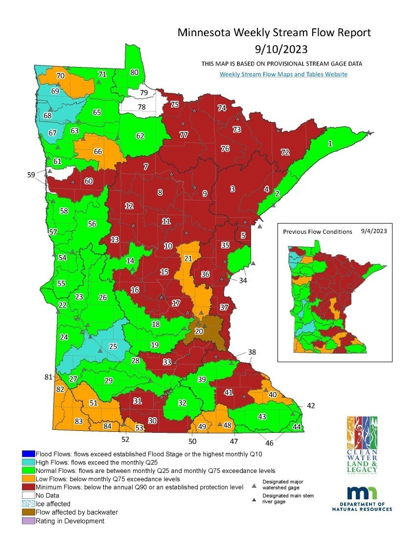
Surface water appropriations are contingent upon flows in the HUC8 level watersheds (as opposed to the HUC4 watersheds that are used for Drought Phase specification).
The low flow management plan for the Mississippi River has been in effect since July 31. The plan imposes certain restrictions on dam operators and is designed to help ensure water is available for hydropower generation, public water supply, and to protect aquatic resources downstream.
Minnesota statute requires the DNR to limit consumptive appropriations of surface water under minimum flow conditions to protect instream ecology and downstream public water supplies. Water use types considered for suspension include irrigation, dust control, sand and gravel washing, and construction non-dewatering. Permits for public drinking water are not suspended.
Twenty-eight watersheds are below the minimum flow threshold, Q90, this week. Six surface water appropriation permits were suspended on Sept. 10 in the Mississippi River-Shakopee watershed (No. 33), four permits were suspended in the Zumbro River watershed (No. 41) on Sept. 13, and one permit was suspended in the Little Fork River watershed (No. 76) on Sept. 13.
101 additional surface water appropriation permits are currently suspended in the Crow Wing River (No. 12), Redeye River (No. 13), Mississippi River-Sartell (No. 15), Sauk River (No. 16), Kettle River (No. 35), Marsh River (No. 59), Two Rivers (No. 70), Rapid River (No. 78) and Rainy River-Baudette (No. 79) watersheds.
This week flows dropped below minimum flow (Q90) in two watersheds: Blue Earth River (No. 30) and the Wild Rice River (No. 60). Permit suspension guidelines require five days of flows below Q90 prior to suspending permits. DNR water appropriation hydrologists will be reviewing permits in these watersheds for potential temporary suspension pending any changes to precipitation, river flows and seasonal water appropriation and use.
A permit suspension notification was sent to 20 surface water appropriation permit holders in the Mississippi River-Grand Rapids (No. 9) and Big Fork River (No. 77) watersheds. The last day of pumping for surface water appropriation permit holders subject to suspension in these watersheds will be Monday, Sept. 18.
Minimum stream flows are persisting in the Mississippi River – Headwaters (No. 7), Leech Lake River (No. 8), Mississippi River - St. Cloud (No. 17), Snake River (No. 36), Lower St. Croix River (No. 37), Watonwan River (No. 31), Mississippi River – Lake Pepin (No. 38), Rainy River – Headwaters (No. 72) watersheds. Although minimum stream flows persist, there are currently no surface water appropriation permits with consumptive uses eligible for temporary suspension in the Nemadji River (No. 5), Vermillion River (No. 73), and Rainy River-Rainy Lake (No. 74) watersheds.
The DNR is taking the following actions:
- Notifying water suppliers that have moved to the Drought Warning or Drought Restrictive Phase of the need to implement water conservation requirements for demand reduction.
- Communicating with public water suppliers in southeast Minnesota to understand whether there are any water supply issues occurring due the extreme and exceptional drought in that area.
- Communicating with permittees whose permits will be suspended via email and certified letter.
- Continuing to monitor streams where flows have reached minimums that may trigger appropriations permit suspensions.
-
Monitoring precipitation and water levels.
Precipitation Forecast
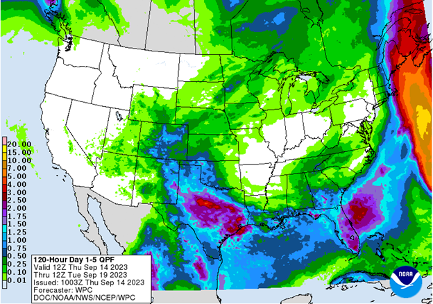
Analysis
As of Sept. 14, the five-day Quantitative Precipitation Forecast produced by NOAA’s Weather Prediction Center illustrates a prediction of very moderate precipitation over most of the state. This forecast is valid from Sept. 14 to Sept. 19. For updated forecasts, see the NOAA Weather Prediction Center’s Quantitative Precipitation Forecast.
For additional information contact:
|