Weekly drought update
August 31, 2023
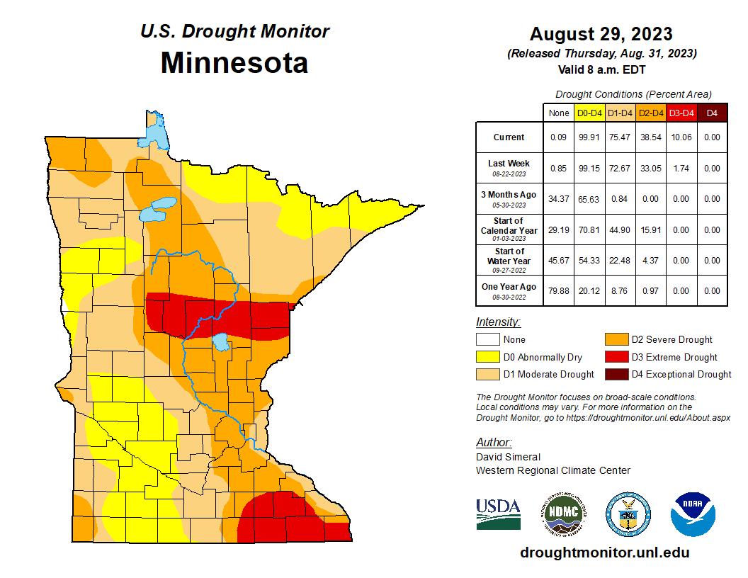
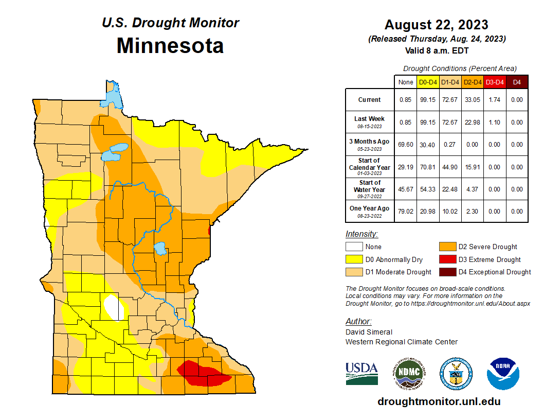
Drought conditions intensified in east-central and southeastern Minnesota over the past week. It is important to note that other areas of the state, where no changes in drought status were observed, are moving deeper into their respective drought classifications. Hot and dry weather forecasted over the next two weeks is likely to result in an expansion of severe and extreme drought conditions.
Two watersheds in southeastern Minnesota have moved to the Drought Restrictive Phase (Upper Mississippi-Iowa-Skunk-Wapsipinicon and Upper Mississippi-Maquoketa-Plum). In addition, flows throughout the Mississippi River headwaters have declined considerably over the past week and, if the trend continues, the Mississippi Headwaters Watershed may also move to the Restrictive Phase in the near future.
Key Points:
- Two watersheds have moved to the Drought Restrictive Phase.
- Four watersheds remain in the Drought Warning Phase.
- Six watersheds remain in the Drought Watch Phase.
- The Mississippi Low Flow Management Plan for dam operation continues to be in effect.
- Surface water appropriation permit suspensions are being implemented in some watersheds and permits are under review in other watersheds that have recently reached critically low flows (described in Streamflow Information below).
Current conditions
The weekly U.S. Drought Monitor map released Thursday, August 31 shows that virtually all of Minnesota continues experiencing abnormally dry, moderate, severe or extreme drought conditions.
- 24% percent of Minnesota is experiencing abnormally dry conditions, decreased from 26% last week.
- 37% percent of the state is in moderate drought, decreased from 40% last week.
- 29% percent of Minnesota is in severe drought, decreased from 31% last week.
- 10% of the state is in extreme drought, increased from 1.75% last week.
Management actions
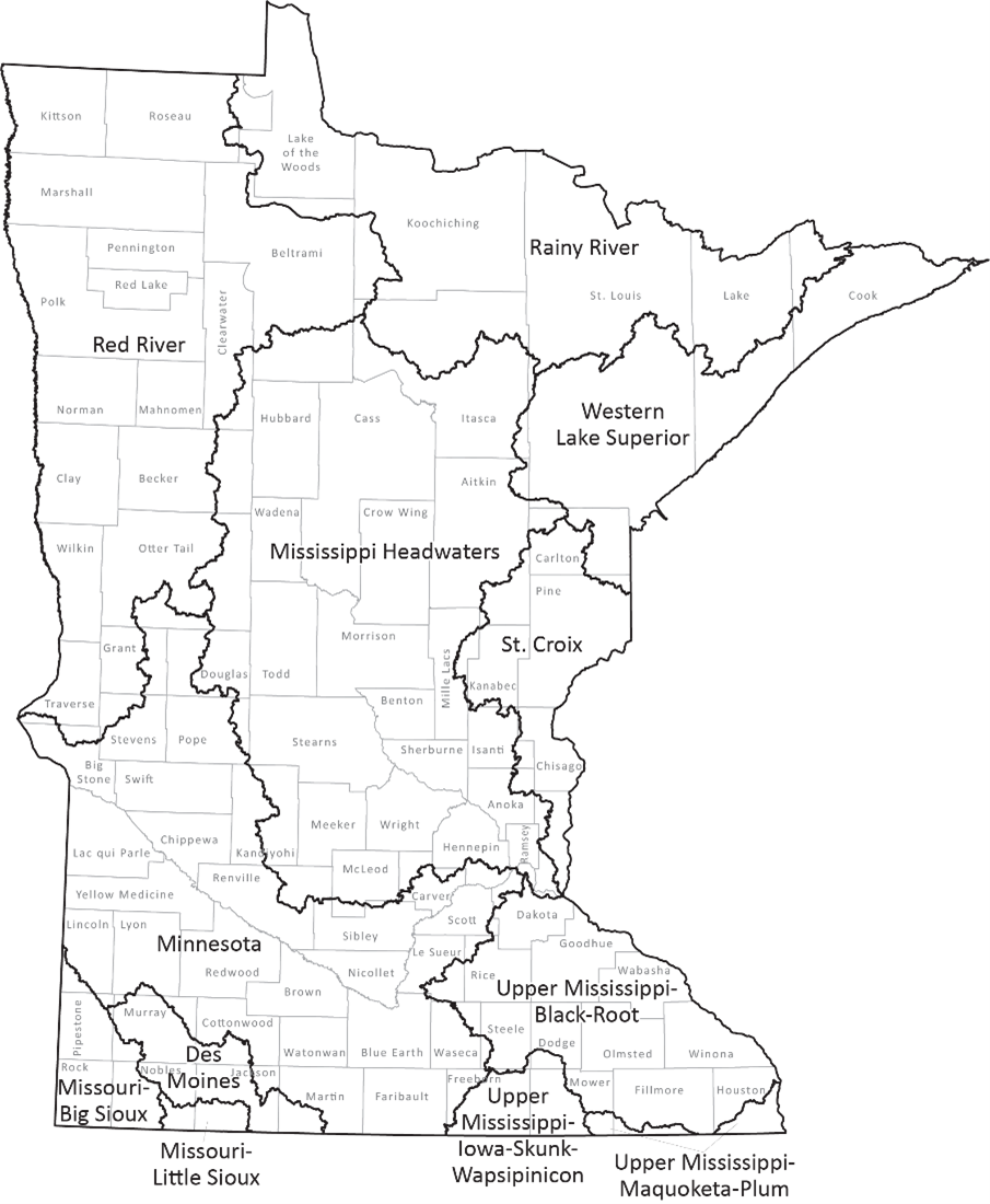
Two watersheds have moved to the Drought Restrictive Phase as prescribed in the Statewide Drought Plan:
- Upper Mississippi-Maquoketa-Plum
- Upper Mississippi-Iowa-Skunk-Wapsipinicon
Four watersheds remain in the Drought Warning Phase as prescribed in the Statewide Drought Plan:
- Croix
- Mississippi Headwaters
- Upper Mississippi-Black-Root
- Missouri-Big Sioux
These watersheds remain in the Drought Watch Phase as prescribed in the Statewide Drought Plan:
- Western Superior
- Rainy River
- Minnesota Basin
- Des Moines River
- Missouri-Little Sioux
- Red River
While their watershed is in the Drought Warning Phase, public water suppliers are required to implement water conservation measures with the goal of reducing water consumption to 50% above January levels. For watersheds in the Drought Restrictive Phase, public water suppliers are required to implement water conservation measures with the goal of reducing water consumption to 25% above January levels. However, municipalities in any watershed may choose to implement restrictions for water conservation while current dry conditions persist.
The DNR is taking the following actions:
- Communicating with permittees whose permits will be suspended, via email and certified letter.
- Notifying water suppliers in the watersheds that reach Drought Restrictive Phase of water conservation requirements for demand reduction.
- Continuing to monitor streams where flows have reached minimums that may trigger appropriations permit suspensions.
- Re-convening the State Drought Task Force on September 14 to discuss intensifying drought conditions.
- Monitoring precipitation and water levels.
Drought conditions typically lead to increased irrigation for crops, lawns and athletic fields, which leads to additional strain on Minnesota’s water resources. Moderate drought (D1) is characterized by dry soil conditions, stressed crops, and river/lake levels being lower than normal. Severe drought (D2) is characterized by very low river flow, hard ground and a higher potential for severe impacts on agriculture. Extreme drought (D3) may result in early harvest of corn and increased risk of wildfires.
Streamflow information
The low flow management plan for the Mississippi River has been in effect since July 31, 2023. The plan imposes certain restrictions on dam operators and is designed to help ensure water is available for hydropower generation, public water supply, and to protect aquatic resources downstream.
Minnesota statute requires the DNR to limit consumptive appropriations of surface water under minimum flow conditions to protect instream ecology and downstream public water supplies. Water use types considered for suspension include irrigation, dust control, sand and gravel washing, and construction non-dewatering. Permits for public drinking water are not suspended.
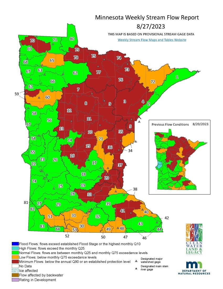
Twenty-six watersheds are below the minimum flow threshold, Q90, this week. Twenty-nine surface water appropriation permits were suspended on August 28, 2023 in the St. Louis River (No. 3), Mississippi River-Brainerd (No. 10) and Pine River (No. 11) watersheds due to minimum flows (below the Q90).
Seventy-one surface water appropriation permits continue to be suspended in the Crow Wing River (No. 12), Redeye River (No. 13), Mississippi River-Sartell (No. 15), Sauk River (No. 16), Kettle River (No. 35), Two Rivers, Rapid River (No. 78) and Rainy River-Baudette (No. 79) watersheds.
This week, flows dropped below minimum flow (Q90) in three watersheds: Mississippi River-Grand Rapids (No. 9), Snake River (No. 36) and Lower St. Croix River (No. 37). Permit suspension guidelines require five days of flows below Q90 prior to suspending permits. DNR water appropriation hydrologists will be reviewing permits in these watersheds for potential temporary suspension pending any changes to precipitation, river flows and seasonal water appropriation and use.
Minimum stream flows are persisting in the Nemadji River (No. 5), Vermillion River (No. 73), and Rainy River-Rainy Lake (No. 74) watersheds. There are currently no surface water appropriation permits with consumptive uses eligible for temporary suspension in these watersheds.
Flows in the Mississippi River at Brooklyn Park dropped over the last week from about 2200 cfs to 1700 cfs. If the hot and dry weather continues (as forecast), it is likely that Mississippi mainstem flows will drop to a level (1500 cfs or lower for five days) that would require further water use restrictions for water suppliers that use the Mississippi River as a water source, including Minneapolis, St. Paul, and St. Cloud.
Precipitation forecast
Analysis
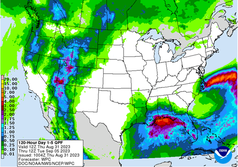
As of August 31, the five-day Quantitative Precipitation Forecast produced by NOAA’s Weather Prediction Center illustrates no rain across nearly all of Minnesota except the northwest corner and a small western portion of the state, where less than one-tenth of an inch of rain is forecast. This forecast is valid from August 31 to September 5. For updated forecasts, see the NOAA Weather Prediction Center’s Quantitative Precipitation Forecast.
The computer models are currently showing a dry and very warm start to September, with little to no precipitation and high evaporation. Normal precipitation for September in Minnesota is generally from 2.5 to 3.5 inches. Several weeks of above-normal precipitation, ideally with soaking rains rather than downpours, would be needed to alleviate drought conditions.
For additional information, contact:
|

