Weekly drought update
August 3, 2023
Drought conditions in Minnesota continued to intensify over the past week. The Minnesota DNR continues to carefully monitor the situation and take steps as outlined in the Minnesota Statewide Drought Plan.
Key Points:
- The Mississippi Low Flow Management Plan for dam operation has been enacted.
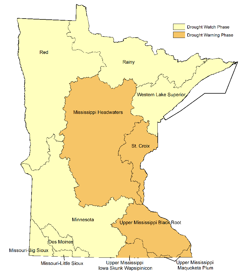
- Four watersheds have moved to the Drought Warning Phase (Mississippi Headwaters, Upper Mississippi Black Root, Upper Mississippi Iowa Skunk Wapsipincon, and Upper Mississippi Maquoketa).
- One watershed remains in the Drought Warning Phase (St. Croix) and seven remain in the Drought Watch Phase.
- Surface water appropriation permits are under review in watersheds having recently reached critically low flows (described in Streamflow Information below).
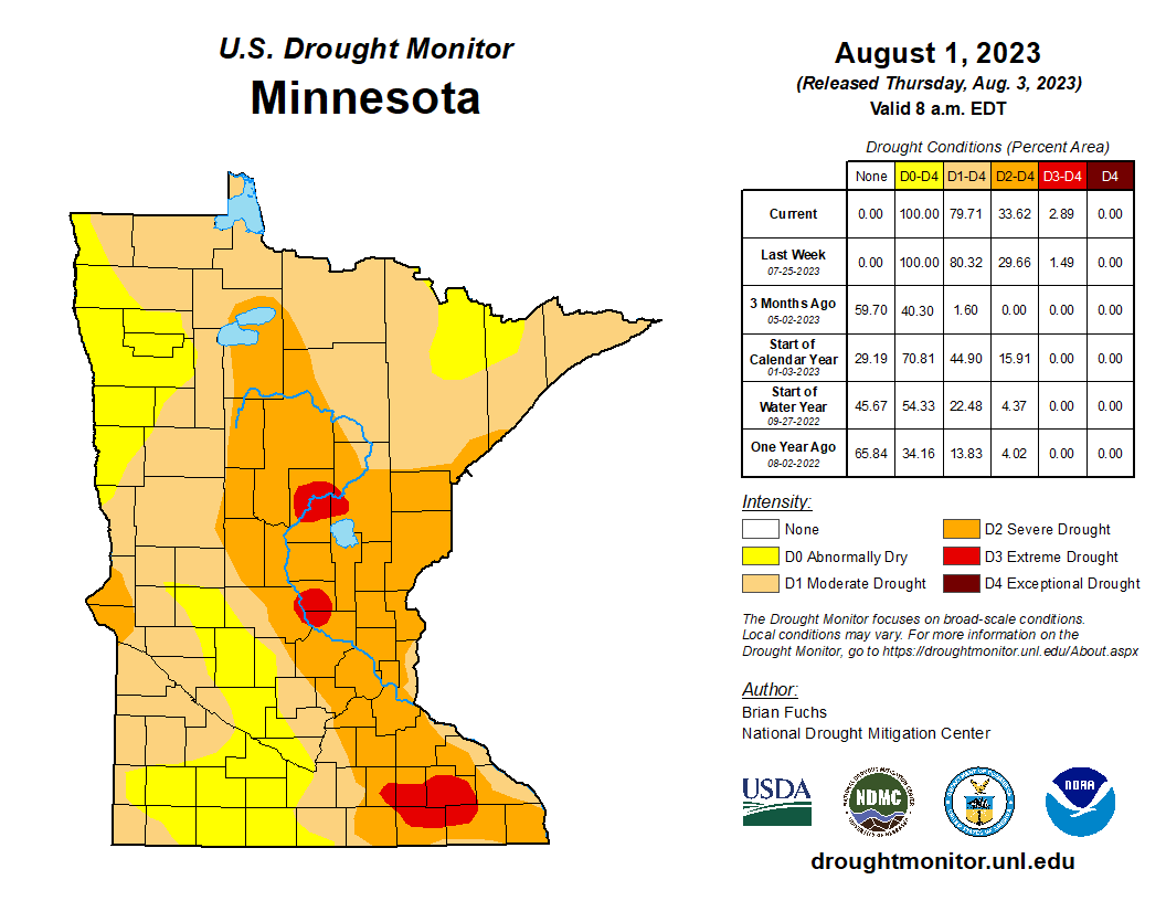
The weekly U.S. Drought Monitor map released Thursday, August 3 shows that all of Minnesota is experiencing abnormally dry and/or moderate drought conditions, with areas of severe and extreme drought expanding in north-central and south-eastern Minnesota.
- 20% percent of Minnesota is experiencing abnormally dry conditions
- 46% percent of the state is in moderate drought, down from 52% from last week
- 31% percent of Minnesota is in severe drought, up from 28% last week
- 3% of the state is in extreme drought, up from 1.5% last week
  Due to continued precipitation deficits, four watersheds have moved to the Drought Warning Phase as prescribed in the Minnesota Statewide Drought Plan:
- Mississippi Headwaters
- Upper Mississippi-Black-Root
- Upper Mississippi-Maquoketa-Plum
- Upper Mississippi-Iowa-Skunk-Wapsipincon
One watershed remains in the Drought Warning Phase as prescribed in the Minnesota Statewide Drought Plan:
These watersheds remain in the Drought Watch Phase as prescribed in the Minnesota Statewide Drought Plan:
- Western Superior
- Rainy River
- Minnesota Basin
- Des Moines River
- Missouri-Little Sioux
- Missouri-Big Sioux
- Red River
When a watershed reaches the Drought Warning Response Phase, public waters suppliers are required to implement water conservation measures with the goal of reducing water consumption to 50% above January levels. However, municipalities in any watershed may choose to implement restrictions for water conservation while current dry conditions persist.
Drought conditions typically lead to increased irrigation for crops, lawns and athletic fields, which leads to additional strain on Minnesota’s water resources. Moderate drought (D1) is characterized by dry soil conditions, stressed crops, river/lake levels being lower than normal. Severe drought (D2) is characterized by very low river flow, hard ground and a higher potential for severe impacts on agriculture. Extreme drought (D3) may result in early harvest of corn and increased risk of wildfires.
Streamflow Information
 The Mississippi Low Flow Management Plan was triggered on Monday, July 31. This plan requires dam operators to make only small adjustments in flows over short periods of time to ensure water is available for hydropower generation, public water supply and aquatic resources downstream. A matrix attached to the plan contains dam-specific guidelines as well as operator contact information to ensure ongoing communication during low flows. More information about the Mississippi Low Flow Management Plan, including USGS real-time flow gauge readings, can be found on the Mississippi Low Flow Management Web Page.
Minnesota Statute 103G.285 requires the DNR to limit consumptive appropriations of surface water under minimum flow conditions to protect instream ecology and downstream public water supplies. Water use types considered for suspension include irrigation, dust control, sand and gravel washing, and construction non-dewatering. Permits for public drinking water are not suspended.
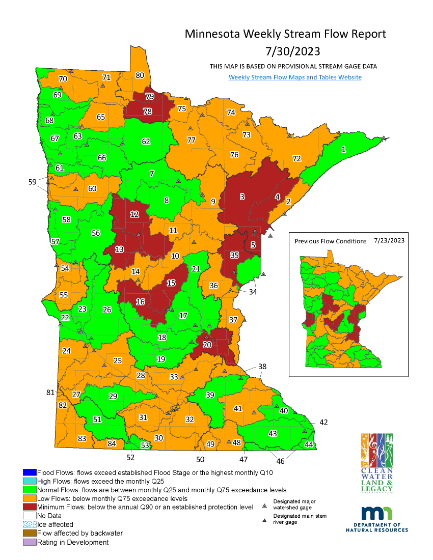
Fifty-one surface water appropriation permits continue to be suspended in the Mississippi River-Sartell (No. 15) and Sauk River (No. 16) watersheds. Two surface water appropriation permit holders in the Rapid River (No. 78) and Rainy River-Baudette (No. 79) watersheds received notice of a temporary suspension effective, August 6, due to minimum flows in those watersheds.
Minimum stream flows are persisting in the Nemadji River (No. 5) – no surface water appropriation permits, Mississippi River-Metro (No. 20), Kettle River (No. 35), Crow Wing River (No. 12), Redeye River (No. 13) watersheds. DNR water appropriation hydrologists continue their review of surface water appropriation permits in these watersheds for potential temporary suspension.
This week flows dropped below minimum flow (Q90) in two watersheds: St. Louis River (No. 3) and Cloquet River (No. 4) watersheds. Permit suspension guidelines require five days of flows below Q90 prior to suspending permits. DNR water appropriation hydrologists will be reviewing permits in these watersheds for potential temporary suspension pending any changes to precipitation and river flows.
The Snake River (No. 36), Lower St. Croix River (No. 37), Bois de Sioux River (No. 54), and Mustinka River (No. 55) watershed flows increased above the Q90 this week with some rainfall late last week.
The DNR is taking the following actions:
- Notifying water suppliers in the watersheds that reach Drought Warning Phase of water conservation requirements for demand reduction
- Enacting the Mississippi Low Flow Management Plan
- Continuing to monitor streams where flows have reached minimums that may trigger appropriations permit suspensions
- Monitoring precipitation and water levels
- Initiating internal and external awareness through a GovDelivery message
- Updating the DNR’s drought webpage with current information
Precipitation Forecast
 Analysis
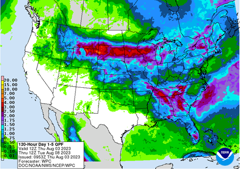
- As of August 3, 2023, the five-day Quantitative Precipitation Forecast, as produced by NOAA’s Weather Prediction Center, illustrates a forecast of two inches or more over most of southern Minnesota and between one and two inches over most of central Minnesota. The remainder of the state is expected to receive less than one inch of rainfall. This forecast is valid over the period from August 3 to August 8. For updated forecasts, see the NOAA Weather Prediction Center’s Quantitative Precipitation Forecast.
For additional information, contact:
|