|
|
|
March 23, 2023
Groundwater Atlas of Cass County
Now Available
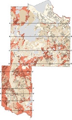
The Minnesota Department of Natural Resources has published the Groundwater Atlas of Cass County (Part B). This atlas covers groundwater conditions and sensitivity to pollution, expanding on the Geologic Atlas of Cass County (Part A) previously published by the Minnesota Geological Survey.
The groundwater atlas can help identify viable water sources, evaluate supply, identify recharge sources and flow, manage sustainability, guide decisions for well and septic system construction, assist in well head protection for public water supply, and assess pollution sensitivity.
Printed atlases can be purchased from Minnesota Geological Survey Map Sales,
612-626-2969. PDF and GIS files can be downloaded from the links below and from the County Atlas Status List web page, where you can also find the other completed counties and links to Part A.
Cass, C-43
A workshop introducing the results of the atlas is planned for May 16. Watch the “News Flash” section of the Cass County Environmental Services website closer to the date.
For more information visit the Groundwater Atlas Program page on the DNR website. For questions contact Paul Putzier, Hydrologist Supervisor, 651-259-5692, paul.putzier@state.mn.us
|
|
|
Part A Releases: St. Louis, Aitkin, and Steele Counties
The geologic atlases for St. Louis, Aitkin, and Steele counties were recently published by the Minnesota Geological Survey at the University of Minnesota.
- Paper copies are available through our Map Sales Office (mgs@umn.edu).
- Digital files of the plates and data will be posted to the MGS website in the coming weeks.
|
|
County Atlas Program
Geology (Part A): Minnesota Geological Survey
Barbara Lusardi, Associate Director, 612-626-5119
Groundwater (Part B): Minnesota Department of Natural Resources
Paul Putzier, Supervisor, 651-259-5692
The Minnesota Environment and Natural Resources Trust Fund and Clean Water Fund provide partial funding for this project.
|
|
