|
By Ceil Strauss, DNR, State Floodplain Manager
During the sunnier, relatively warm February days, many of us start thinking about our plans for the spring - expanding our native garden areas, converting a bit more lawn to something more pollinator-friendly, or maybe a more ambitious total lawn replacement.
It's worth checking with your community, watershed district or county Soil and Water Conservation (SWCD). They often have helpful resources, and may offer classes or have staff who can give guidance. Some even provide cost-share funds to do native gardens or "rain gardens."
The DNR and Board of Water and Soil Resources (BWSR) also have many useful resources and links to help with your planning. See their key pages:

Editor's note: The author's photo shows a flock of monarch butterflies on a Meadow Blazing Star (Liatris ligulistylus) in an area that was lawn less than a year earlier. Over 20 monarch butterflies were visiting the new plants in August 2022, prompting a couple city parks staff to knock and ask about the plants!
|
Back by popular demand!
Upcoming dates and topics:

A series of FREE one hour virtual trainings on floodplain and shoreland management topics is in progress January through March 2023. The timing will be similar to our Winter 2022 series, with trainings offered 1-2 pm on Mondays, and 9:30-10:30 am on Wednesdays.
Use the "Register" link next to each training to sign up.
You'll also be able to find the registration links and more details about each training on DNR's Upcoming Live Training page, or via the link at the top of DNR's Shoreland and Floodplain Education and Training Center.
Upcoming trainings
-
2/13/2023 (Mon), 1-2 pm: Dealing with Zone As Register
|
-
2/27/2023 (Wed), 9:30-10:30: Floodplain Higher Standards Register
-
3/1/2023 (Wed), 9:30-10:30: Minnesota's State Floodplain Management Model Ordinance Register
-
3/6/2023 (Mon), 1-2 pm: Flood Insurance Basics (including Risk Rating 2.0) Register
|
-
3/13/2023 (Mon), 1-2 pm: Hydrology & Hydraulics for Non-Engineers Register
-
3/20/2023 (Mon), 1-2 pm: Shoreland Higher Standards Register
-
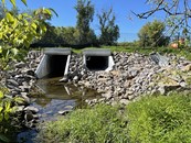
3/22/2023 (Wed), 9:30-10:30 am: Floodplain Culverts Register
|
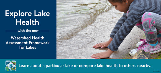
Watershed Health Assessment Framework (WHAF) adds new lake health tool
The Minnesota Department of Natural Resources has created a new online tool, called the Watershed Health Assessment Framework for Lakes (WHAF for Lakes), providing easy access to water quality and health information for thousands of Minnesota lakes.
WHAF for Lakes is part of the DNR's Watershed Health Assessment Framework and is funded by the Clean Water, Land and Legacy Amendment.
"Our staff did very innovative work over the past year to create this valuable new tool," Ecological and Water Resources Division Director Katie Smith said. "WHAF for Lakes will benefit anyone who wants to know more about a particular lake's water quality and the health of the aquatic habitat and community in that lake. It will also help guide decisions about lake protection and restoration."
Compare health of different lakes
Users can compare a lake's health measures to other nearby lakes. Along with graphics showing lakes' relative water quality, biology, and hydrology, WHAF for Lakes includes information about basic lake characteristics and lake stewardship. Quick access to this information will help Minnesotans, local government, and water resource agencies work together on comprehensive watershed management efforts.
A lake's watershed includes all land and surface water upstream of a lake outlet that contribute water to that lake. Land uses within a watershed influence lake health. Alterations of the land, the shoreline, and nearshore vegetation affect the quality of the water and the health of the aquatic community in a particular lake.
What's a healthy lake?
"A healthy lake is one that is nearest to its natural state — free from pollution and with a natural shoreline that protects the bank and filters runoff — which allows it to withstand changing conditions and seasonal fluctuations," Smith said. "Healthy lakes depend on people who value these resources and invest in the protection and restoration of the water, watershed, and biology."
WHAF for Lakes can be accessed by searching for a particular watershed, exploring watershed health with the WHAF Map, or using the DNR’s popular LakeFinder page.
Note: Reprinted from recent DNR press release.
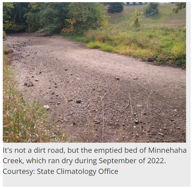
For the second year in a row, significant drought conditions developed in Minnesota during 2022, this time in response to quick-hitting and steep precipitation deficits. Unlike the previous year's drought, which hit northern Minnesota the hardest and peaked during late summer, this one originated in southern Minnesota and escalated during the fall. As of early November 2022, the 2021 drought was the larger and "worse" of the two episodes in all categories, though the 2022 drought was still underway and likely to extend into 2023.
Another major difference was speed of drought onset. The 2021 drought had built slowly since at least mid-2020, and possibly since late in the 2019-20 winter. When June through August 2021 became northern Minnesota's warmest and fourth-driest on record, it only accelerated and worsened a regional drying process that was already well underway.
|
"Flash Drought" definition
By contrast, the episode in 2022 qualified as a "flash drought," defined by NOAA and the National Integrated Drought Information System as the rapid onset of drought conditions. Late winter and spring had been very wet, with February through May of 2022 ranking 8th wettest on record, and over 40% wetter than 20th century averages. These wet conditions were especially pronounced in northern Minnesota, which saw significant and historic flooding in the same areas that had seen the highest levels of drought just eight months earlier.
In southern Minnesota, the rains stopped abruptly during May of 2022, and June and July both had just a quarter to a third of normal precipitation in many areas. August had near-normal precipitation and was even wet in some areas, but September became the driest on record in the Twin Cities, and October finished sixth driest. The period from June through October ended 11.52 inches short for the Twin Cities, marking the area's largest five-month deficit on record, when comparing historical precipitation to what would have been "normal" for the time.
Factors limiting impacts
The precipitation shortfalls were impressive, but two factors limited the severity of the drought categories during summer and fall: first, the wet spring had provided some "cushioning" against massive water losses, slowing down the onset of dire conditions. Second, the summer was warm but not nearly as warm or hot as 2021. Extremes of heat can speed speed up water loss and intensify moisture stress. Fortunately, this summer's heat was less severe than what Minnesota has experienced historically during dry summers, and did not play a major role in worsening this episode.
Note: This is a reprint of Minnesota Climatology Office's The Drought of 2022 posting (last updated Nov. 8, 2022).
|
The National Flood Insurance Program (NFIP) has had many short extensions since the last five-year extension that expired Sept. 30, 2017. The latest extension was set to expire Dec. 30, 2022. On Dec. 29, the President signed legislation passed by Congress that extends the NFIP’s authorization to Sept. 30, 2023.
FEMA's Congressional Reauthorization for the NFIP page should have the latest updates. FEMA reports that they and Congress have never failed to honor the flood insurance contracts in place with NFIP policyholders. Should the NFIP’s authorization lapse, FEMA would still have authority to ensure the payment of valid flood claims with available funds.
|
|
 |

However, FEMA would stop selling and renewing policies for millions of properties in communities across the nation. Nationwide, the National Association of Realtors estimated in 2017 that a lapse might impact approximately 40,000 home sale closings per month.
|
FEMA Region 5 staff (based in Chicago, IL) are continuing their monthly one hour virtual training series in 2023. They are FREE!
It's not too late to register for many training topics!
Upcoming "Managing your Community's Floodplain" monthly series dates and topics:

Note: All held 9-10 am Central Time.
-
Feb. 22, 2023: NFIP Fundamentals for New Floodplain Managers; Registration Link
-
March 29, 2023: Substantial Improvement/ Damage; Registration Link
-
April 26, 2023: Development Permitting; Registration Link
-
May 31, 2023: NFIP Compliance; Registration Link
-
June 28, 2023: Insurance is Mitigation; Registration Link
These trainings and registration links are also available on DNR's Floodplain Training and Education page.
|
FEMA recently released their latest video Risk Rating 2.0 - Equity in Action: What is Built and Covered.
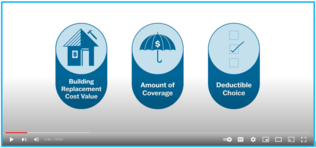
This ten minute video covers:
- How building Replacement Cost Values (RCVs) are determined
- Coverage available for buildings and contents
- Options for Deductibles
For more information about flood insurance, see FEMA's Risk Rating 2.0: Equity in Action page
|

Talk with FEMA and DNR Floodplain program representatives during monthly virtual Minnesota Floodplain Management Office Hours. Hours are 10-11 am, typically on the fourth Thursday of the month (but a few are adjusted).
Upcoming monthly hours (Note: all are 10 - 11 am central time)
Where: Teams. No registration is required. Select a date to get the Teams meeting appointment.
These office hour dates and links are also available on DNR's Floodplain Training and Education page.
|
Important Dates to Note:
(since December 2022 Water Talk and upcoming in next couple months)
|
|
 |
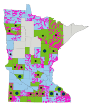
Preliminary Maps
- February 2023 - Dodge Countywide, Stevens (revised panels), Wilkin (panels) and Winona Countywide
- April 2023 - Wabasha Countywide
Local Officials Meetings & Open Houses
- February 15, 2023 - St. Louis Countywide, Virginia option; Local Officials Meeting and 5-7 pm public Open House
- February 16, 2023 - St. Louis Countywide, Duluth area option; Local Officials Meeting and 5-7 pm public Open House
- April 5, 2023 - Chippewa Countywide; Local Officials Meeting and 5-7 pm public Open House
- April 2023 - Murray Countywide Flood Risk Review meeting, Nashua (Wilkin) Better Data LOMR Flood Risk Review meeting and Windom (Cottonwood) Better Data LOMR Flood Risk Review meeting
90-Day Appeal Periods
- Waseca County - 12/21/2022 to 3/20/2023
- Le Sueur County - February to May 2023
Letters of Final Determination (LFDs)
- March 2023 - Lincoln Countywide and Olmsted (Zumbro panels)
Effective (6 months after LFD date)
Additional Map Update Information:
|