Going with the Flow
What do you think of when you see a meandering blue line on a map? Does your mind's eye picture gently flowing water as it travels downstream?
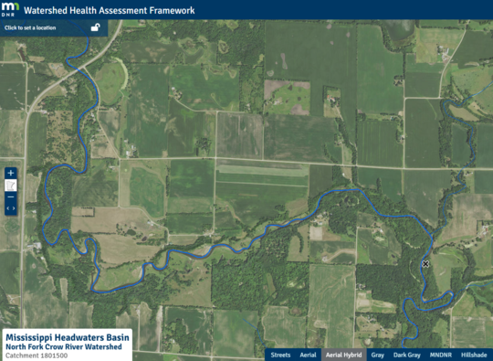
The North Fork Crow River as it meanders downstream
It is important to remember that the ribbon of blue on the map above is not just water. There are so many other things that are 'going with the flow'. The water carries bits and pieces of soil and rock, it carries bugs and fish; and maybe most importantly it carries energy.
Have you tried to stand still as a stream rushes downstream around you? The force of the water can easily knock you off your feet. It can be exhilarating and a bit unnerving. It is no surprise that a force like that can carve canyons and valleys, reshape stream banks and move boulders. Given time, the power of water can reshape just about anything.
What happens when we block the flow?
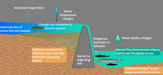
Dams and other barriers force all that movement to pause; water, sediment, plants, fish, bugs; and yes - all that energy - are captured and start to accumulate behind the barrier. In some cases, there is a controlled release of water over a hydropower dam, converting water power to energy for human consumption.
But what happens to rest of the stuff that isn't released over the dam?
There are a whole lot of trade-offs to consider.
Most of it will just keep accumulating. Water will create a reservoir, sediment will settle to the bottom and begin to fill it. Fish, bugs and plants are trapped and disconnected from downstream habitats.
And all that energy has to go somewhere. The water below the dam carries less debris so it is 'sediment hungry'. It will use its power to pound and erode the stream banks until the water and sediment are back in balance -- until it hits another dam, culvert or levee that upsets that balance again.
 Accounting for climate impacts
There are also impacts from dams that may become more exaggerated with Minnesota's changing climate. Here are some examples:
- Water trapped in reservoirs evaporates more quickly, warming the water and leaving less in our streams during dry spells.
- Dams block aquatic animals from reaching cooler upstream tributaries and other habitat refugia.
- Reservoirs favor invasive plant and animal species that outcompete native species, reducing biodiversity.
- Streams with dams are more vulnerable to extreme, localized flood events.
These impacts make a river system less resilient to our warming climate and to our increasingly variable precipitation patterns.
Reconnecting for the future
In Minnesota, our efforts to remove dams and reconnect some of our river systems has not gone unnoticed. For example, spawning sturgeon were documented in the upper Otter Tail River for the first time in more than 100 years, after restoration efforts restored fish passage in the Red River Basin. Other species return as well; on average 73% of missing species make their way upstream after a dam removal.
A full accounting of the ecological, economic and social tradeoffs is important when the fate of a dam is being considered. Sometimes a fish bypass or other alteration can help us meet the challenges part way. But ecological success stories are brightest when rivers flow free, floodplains are connected and streams are restored so they can once again 'go with the flow'.
How Connected is Your River?
On the ground it can be difficult to see the ways that a river can become disconnected. A quick exploration with a WHAF Connectivity Health Scores can help with that. Let's take another look at the North Fork Crow River to further investigate the connectivity of rivers and streams in this watershed.
-
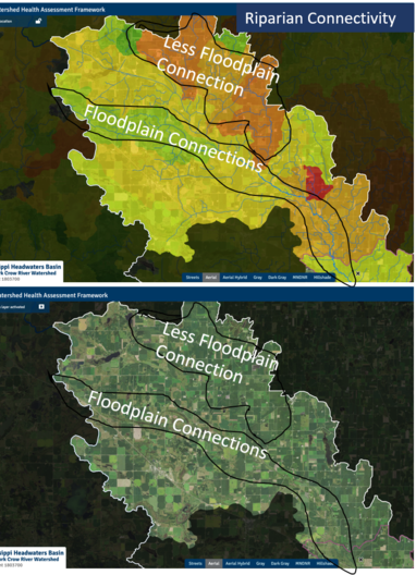
Riparian Connectivity - Does the river have access to its floodplain?
Using the Riparian Connectivity scores over the aerial image, you can see that the upper reaches of the main stem have some wiggle room with access to their floodplain, but some of the tributaries have land uses and levees that disconnect streams from their riparian lands.
 |
|
Open this Floodplain Connectivity map in your own browser. Zoom in to compare the condition of the riparian (near stream) lands.
The mainstem river has some nice wide natural areas for the river to connect to its floodplain.
Some tributaries have land uses that limit floodplain connections. These streams contain excess energy that will carry more sediment downstream.
|
-
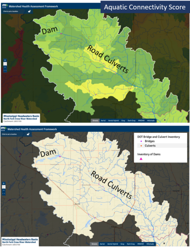
Aquatic Connectivity - How many dams, bridges and culverts are impacting the stream?
You can use the Aquatic Connectivity health score together with points that show dams, culverts and bridges. Add the 'Streets' basemap to look for more road and stream intersections. The density of roads can help indicate where additional structures may be present that impact streams and the health of aquatic communities.
 |
|
Open the Aquatic Connectivity map in your browser to view this health score and the related data layers.
The point data is from an inventory of dams and structures on roads, but smaller roads and private structures are not included. The dots on the map only represent some of the structures that disconnect our rivers.
|
As stream systems across Minnesota flow together, their energy level and sediment loads continuously merge and recalibrate. When given the space they need, free flowing rivers will access their floodplain to deposit excess sediment, dissipate energy and create quality habitat. It is not always easy, but if we find ways to remove barriers and give our rivers a larger floodplain, we can enhance our natural and human communities while making our river systems healthier and our watersheds more resilient. Win, win!
|