New 2022 State Climate Summaries released from NOAA offer up-to-date, local perspectives on climate in each state, covering the entire United States plus Puerto Rico and the U.S. Virgin Islands. The new State Climate Summaries have been developed in partnership with the Cooperative Institute for Satellite Earth System Studies (CISESS), six Regional Climate Centers (RCCs), and individual state climatologists. An interactive website hosted by CISESS gives the public easy access to the information.
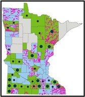
The State Climate Summaries spell out recent local conditions for each state and provide insights about the state’s climate outlook based on historical trends. (See the Minnesota information page.)
The summaries, which are available both as web pages and downloadable PDFs ranging from four to six pages in length, describe historical temperature and precipitation conditions for each state and use several visual aids to show past observations and plausible future projections.
Specifically, the summaries cover:
- Historical climate variations and trends
- Noteworthy extreme weather events
- Future projections of climate conditions over the next century
- Past and future conditions of sea level and coastal flooding, where applicable
Please see links to the full web story for more information!
|
It's Here!
A major update to the Minnesota State Model Floodplain Ordinance has been in the works for well over a year, and it is now available on the DNR's model floodplain ordinance page.
What has changed?
-
More accurate reflection of federal and state regulations: A detailed review was done of all state & federal regulations against the previous model. One major state law requirement overlooked in the previous models was added (see Regulatory Floodplain article below), and model language not directly tied to regulations or FEMA published technical guidance is called out as optional.
-
Graphics: Added several helpful graphics
-
Optional language font: Blue bold font used to call out optional higher standards and clarifying language. The copy of the ordinance posted online contains commentary in the margin explaining whether the language is:
- A higher standard - and why a community might want to add that requirement
- Optional language that may be included to provide more allowable development options in the community, or clarifying language
-
Plain language: A concerted effort was made to detail complex provisions in an understandable manner, and have the order flow in a way that makes sense for local officials who may not be familiar with their floodplain ordinance.
Learn More About the New Model
A virtual one hour training is being offered 3/2/2022 (Wed), 9:30-10:30: Minnesota's New State Floodplain Management Model Ordinance & Rollout Register
|
The Rollout
-
Required ordinance updates: All local governments should expect to use the new model when they are required to update their ordinance. The main situation where communities will be required to update their floodplain ordinance is when new FEMA maps are issued and communities must update their ordinance to adopt the new maps.
-
Community option to adopt sooner: Communities may choose to update their floodplain management ordinance earlier to take advantage of the clearer updated model, especially if the community would like to consider adding higher standards.
If you'd like to start working on updating your community's floodplain management ordinance, or discuss your options, contact DNR's Floodplain Management staff.
New FEMA Virtual Training Series

FEMA's Region 5 (which includes Indiana, Illinois, Michigan, Minnesota, Ohio and Wisconsin) has started the "Managing Your Community's Floodplain" series. Topic #1 kicked off on Wednesday, January 26, 2022 with "Disaster Recovery Reform Act Section 1206." Close to 350 attended (including at least some of our Minnesota local officials)!
|
Monthly Trainings
- FREE - One Hour Virtual Trainings
- Targeted at local officials
- Held 9-10 am (CT) on Wednesdays (usually last Wednesday of month, but adjusted for holidays)
|
|
 |
Save the date for:

-
Topic #2 February 23, 2022: Increased Cost of Compliance Coverage (ICC) -
Registration
-
Topics #3 March 30, 2022: NFIP Fundamentals for New Floodplain Managers -
Registration
-
Topic #4 April 27, 2022: Substantial Damage Assessments and the SDE Tool -
Registration
-
Topic #5 May 25, 2022: Development Permitting
-
Topic #6 June 29, 2022: NFIP Compliance
-
Topic #7 July 27, 2022: Managing FIRM Map Changes and Community Acknowledgement
-
Topic #8 August 31, 2022: Coastal Resilience and Floodplain Management
-
Topic #9 September 28, 2022: Resolving Potential Violations
-
Topic #10 October 26, 2022: Higher Standards
-
Topic #11 November 30, 2022: Basement Flooding Mitigation
-
Topic #12 December 14, 2022: No Adverse Impact
|
For more virtual webinar information or questions, contact Brian Killen, FEMA Region 5, Senior Floodplain Management Specialist.
*Certified Floodplain Managers (CFMs), please note that the webinar information has been submitted to ASFPM for pre-approval for Continuing Education Credits (CECs).
By Ceil Strauss, DNR, State Floodplain Manager
Most local officials are accustomed to their floodplain ordinance regulating the area shown as some type of Zone A on FEMA's regulatory maps, and the areas adjacent to that mapped floodplain that is below the federal Base Flood Elevation (BFE). However, while updating the state model floodplain ordinance, DNR staff made a correction to clarify the area subject to the minimum state regulations includes the area covered by the Regulatory Flood Protection Elevation (RFPE), not just the area covered by the BFE. This is consistent with Minnesota Rules, part 6120.5700, Subp. 3.,A.
Regulatory floodplain goes beyond FEMA mapped areas
The "Regulatory Floodplain" goes beyond the area covered by the BFE, by adding the required freeboard elevation plus applicable stage increase for that area, which means expanding the regulated area to include the additional area covered by that one to 1.5 foot elevation increase.
Note that Minnesota's Regulatory Flood Protection elevation starts with the BFE, and adds at least one foot of freeboard - a safety factor - plus up to 0.5 feet stage increase to accommodate rise due to filling of the flood fringe areas.
The new Minnesota model floodplain ordinance adds a more accurate administration of state floodplain regulations with the addition of the Regulatory Floodplain definition (section 2.139) and clarification of where minimum state floodplain regulations apply (section 3.13).
Key ordinance language:
-
(Section 2.139) Regulatory Floodplain. The geographic limits of the flood hazard areas regulated through this ordinance, which includes the areas adjoining a wetland, lake or watercourse that have been or hereafter may be covered by the Regulatory Flood Protection Elevation (RFPE) (as illustrated in Figure 2).
-
(Section 3.13) The regulatory limits of the district boundaries shall be further extended outward based on the horizontal extension of the Regulatory Flood Protection Elevation (RFPE) (Figure 2).
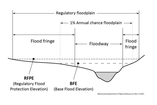
Minnesota Model Floodplain Ordinance "Figure 2: Regulatory Floodplain"
Where do floodplain regulations apply?
-
Within FEMA mapped areas. Local ordinances must adopt FEMA Flood Insurance Rate Maps (or the older Flood Hazard Boundary Maps) - if they exist - and regulate those mapped areas.
-
Within the Regulatory Floodplain, the area including the FEMA mapped Special Flood Hazard Areas AND the adjoining area extending up to the RFPE.
Where else do minimum low floor regulations apply?
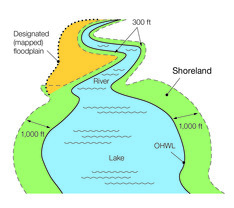
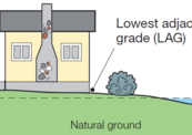
Within Shoreland Districts. The Minnesota Shoreland Management regulations require new structures and additions meet minimum lowest floor elevations within the shoreland district (as shown in shoreland district graphic to right).
The minimum lowest floor elevation is:
- The Regulatory Flood Protection Elevation where the one percent annual chance flood elevation - or the BFE - is known.
- If the RFPE is not known, the lowest floor is the Ordinary High Water (OHW) elevation or the Highest Known Water Level - whichever is higher - plus three feet.
|
Cities and townships served by a municipal water supply can receive up to $50,000 to help residents reduce purchase costs to replace water-efficient toilets, washing machines, dishwashers, irrigation systems, and more. The growing program — now in its third cycle with an unprecedented $1 million to be allocated — has saved municipalities an estimated 450 million gallons of water since 2015. Met Council will begin taking applications on January 31.
|
Two new sample floodplain permit administration forms are now available in the links at the top of the DNR Floodplain Regulations page. The DNR Floodplain Program last updated the sample floodplain permit forms in 2003, so an update was long overdue!
What's New?
- Two separate forms:
-
Full Application: For projects involving buildings, and
-
Simplified Application: For other development in the FEMA mapped floodplain that requires a floodplain permit (i.e., grading, culverts/bridges, etc.).
- Fillable Word Document
- Portions for applicant and local officials:
- First portion of each form is filled out by the applicant.
- Second portion of the form is completed by local officials, and steps through the key review steps to simplify the process.
Example of Form Content

Example of sections on first page for local official to complete. On the sample permit form for structures, the form has a step to verify the ordinance flood district, then a step to determine the Regulatory Flood Protection Elevation (RFPE).
Flexible, optional resource for local zoning officials
Communities are not required to use these sample permit forms. They are provided to assist local zoning administrators to ensure all data is considered and minimum floodplain ordinance standards are met. Use of these forms allows the zoning administrator to clearly communicate all relevant standards to the applicant. Communities may modify these sample forms to add their community specific information, or utilize just the portions of the application forms desired, or applicable in the community.
If you have questions about the forms, or suggestions to make them more helpful for local officials, contact DNR's Floodplain Management staff.
By Ceil Strauss, DNR, State Floodplain Manager
It's not too late to register for many training topics!

A series of one hour virtual trainings on floodplain and shoreland management topics is being offered January through early March 2022. The timing will be the same as we had during our Spring 2021 series, with trainings offered 1-2 pm on Mondays, and 9:30-10:30 am on Wednesdays.
Use the "Register" link next to each training to sign up. (Reminders and links to the training will be emailed, but are not automatic.)
You'll also be able to find the registration links and more details on the DNR's Floodplain Training and Education page.
Recordings To Be Available
Many have requested recordings of these trainings. The plan is to make them available on the DNR's Floodplain Training and Education page within the next couple months, after the recordings have been updated to meet DNR's accessibility standards for sharing materials on the web site.
|
Upcoming dates and topics:
-
1/31/2022 (Mon), 1-2 pm: Dealing with Zone As Register
-
2/2/2022 (Wed), 9:30-10:30: Nonconformities in Shoreland & Floodplains Register
-
2/7/2022 (Mon), 1-2 pm: Shoreland Higher Standards Register
-
2/9/2022 (Wed), 9:30-10:30: Variances - Shoreland Emphasis Register
|
-
2/14/2022 (Mon), 1-2 pm: FEMA Letters of Map Change Register
-
2/16/2022 (Wed), 9:30-10:30: Floodplain Higher Standards Register
-
2/23/2022 (Wed), 9:30-10:30: Floodplain Administration 201 (CUPs, Floodproofing, Variances) Register
|

-
2/28/2022 (Mon), 1-2 pm: Flood Insurance Basics (including Risk Rating 2.0) Register
-
3/2/2022 (Wed), 9:30-10:30: Minnesota's New State Floodplain Management Model Ordinance & Rollout Register
-
3/7/2022 (Mon), 1-2 pm: Hydroclimatic Changes Affecting Minnesota's Water-Related Resources Register
-
3/9/2022 (Wed), 9:30-10:30: Substantial Damage Determinations & Post Flood Responsibilities for Local Floodplain Managers Register
|
Important Dates to Note:
(since December 2021 Water Talk and upcoming in next couple months)
|
|
 |
Preliminary Maps: none
Local Officials Meetings & Open Houses*
- Lincoln County Local Officials Meeting - Jan. 4, 2022, 2-4 pm
- Lincoln County Public Open House - February 2022
- Twin Cities Mississippi River HUC8 (portions of Anoka, Carver, Dakota, Hennepin, Ramsey, and Washington Counties) - Local Official Flood Risk Review Meetings:
- Coon Creek Watershed - March/April 2022
- Elm Creek Watershed - March/April 2022
- West Mississippi Watershed -March/April 2022
*All meetings and open houses expected to be virtual until further notice.
90-Day Appeal Periods
- Blue Earth County - 11/10/2021 to 2/8/2022
Letters of Final Determination (LFDs)
- Lyon County (panels with levees) - March 2022
Effective (6 months after LFD date)
- Rice County (Zumbro watershed panels) - April 6, 2022
Additional Map Update Information:
|