|
|
|
December 28, 2021
Groundwater Atlas of Hennepin County
Now Available
The Minnesota Department of Natural Resources has published the Groundwater Atlas of Hennepin County. This atlas covers groundwater conditions and sensitivity to pollution. It expands on the geologic atlas previously published by the Minnesota Geological Survey.
The atlas can help identify viable water sources, evaluate supply, identify recharge sources and flow, manage sustainability, guide decisions for well and septic system construction, assist in well head protection for public water supply, and assess pollution sensitivity.
The atlas is available online:
-
Groundwater Atlas of Hennepin County
The web page includes geographic information system (GIS) files and PDFs of the report and maps. The GIS link includes files and associated metadata, and an ArcMap file that displays the data as shown on the published maps, with hyperlinks to image files of the published cross sections.
- The geologic portion and other completed counties can be found on the County Atlas Status List.
- Printed atlases can be purchased from Minnesota Geological Survey Map Sales, 612-626-2969.
For Questions about this atlas: Paul Putzier, Hydrologist Supervisor, 651-259-5692, paul.putzier@state.mn.us
|
|
|
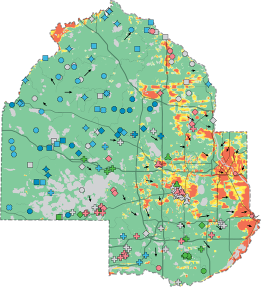
Groundwater Atlas Figure 47 (Modified). Pollution sensitivity of the bedrock surface and groundwater flow directions
The figure shows the most extensive and commonly used aquifers in the county. The dark green color indicates low pollution sensitivity for most of the county, with scattered areas of moderate (yellow) to very high (red).
The blue, green, and pink symbols show locations of well samples analyzed for groundwater residence time. The blue samples were greater than 70 years, indicating aquifers generally more protected from pollution at those locations. The green and pink symbols indicate other conditions that are explained in the report.
|
|
|
County Atlas Program
Geology (Part A): Minnesota Geological Survey
Barbara Lusardi, Associate Director, 612-626-5119
Groundwater (Part B): Minnesota Department of Natural Resources
Paul Putzier, Supervisor, 651-259-5692
Partial funding for this project was provided by the Minnesota Environment and Natural Resources Trust Fund and the Clean Water Fund.
|
|
