Weekly Drought Update - Nov. 8, 2021
Key Points in this Update
Drought:
- Drought conditions in Minnesota improved slightly from last week. As of November 2, 2021, 27 percent of the state is in moderate drought (up from 25 percent last week), 23 percent is experiencing severe drought (down from 30 percent last week), while 7 percent remains in extreme drought (unchanged from last week).
- Conditions are improving, but significant areas of drought remain.
- The state continues in the Drought Warning Phase. Water suppliers in the Rainy River and the Red River watersheds remain in the restrictive phase. Western Lake Superior remains in the warning phase. The Mississippi Headwaters, St. Croix, Minnesota and several southern watersheds remain in the drought watch phase.
- As of November 4, there are 11 active well interference investigations in six counties and five additional cases is in the resolution phase.
Streamflow:
- Eight out of 81 total major surface water watersheds remain below the Q90.
- 96 surface water appropriation permits out of 517 reviewed for potential permit suspension are currently suspended across 12 watersheds throughout the state.
Mississippi River dams:
- Mississippi River low flow plan is no longer in effect. This will be the last Mississippi River dam update.
- All five gages had flows above the trigger flow as of noon on Wednesday.
- Precipitation from this week has caused an upward trend in flow for all gage locations.
Fire danger:
- As of November 4, fire danger is low across the state.
- As of November 4, burning permits are still required in all counties. There are no other designated burning restrictions
Sample Lake Level situation:
- One of the eight reporting lakes decreased 0.36 inches from the previous week.
- Seven of the eight reporting lakes increased from the previous week, from 0.24 to 0.96 inches.
- One of the eight lakes is in the low range.
- Three of the eight lakes are in the below normal range.
- Three of the eight lakes are in the normal range.
- One of the eight lakes is in the above normal range.
Drought Information
Last two weeks of Drought Maps:
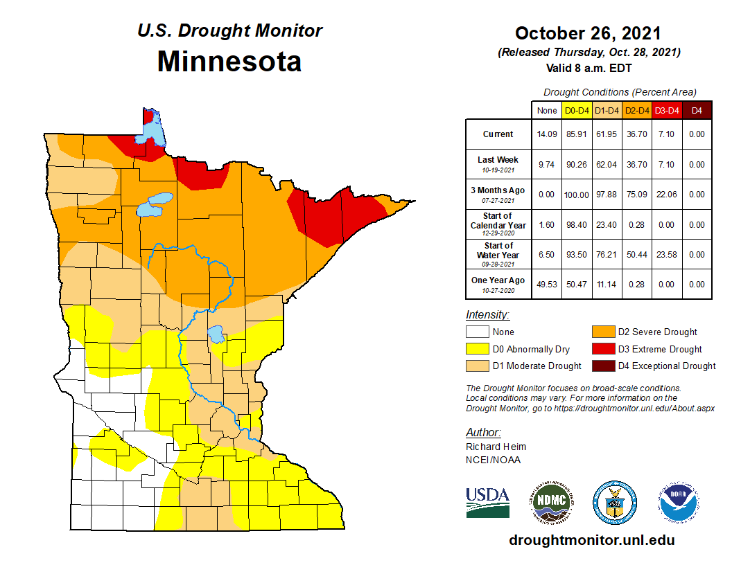 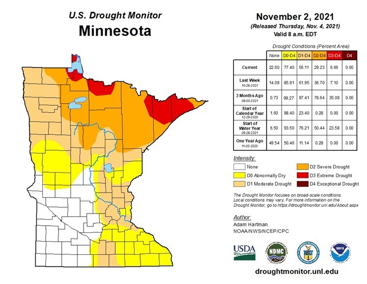 State of Minnesota Drought Monitor map
Drought situation:
- Counties with an area of exceptional drought (D4): 0
- Counties with an area of extreme drought (D3): 6
- Counties with an area of severe drought (D2): 16
- Counties with an area of moderate drought (D1): more than 40
- Counties just abnormally dry (D0 – not drought): 21
- Counties with no designation: 47
- Estimated population in Drought Areas: 3,152,785
Drought management actions:
- The state remains in the drought warning phase of the Statewide Drought Plan.
- Conditions in the Rainy River and the Red River watersheds are improving, but continue to experience severe to extreme drought and water suppliers remain in the restrictive phase. Western Lake Superior remains in the warning phase.
- The Mississippi Headwaters, St. Croix, Minnesota and several southern watersheds remain in the drought watch phase.
- As of November 4, DNR has received 24 well interference complaint forms in six counties. See DNR Well Interference webpage.
- 11 are active investigations.
- Seven were found valid; two are concluded and five are in the resolution/negotiation phase.
- Two were found not valid.
- One was dismissed.
- Three were resolved early by the permitted appropriator.
- The DNR has received 34 verbal complaints. At least six were resolved by nearby permitted appropriators.
Streamflow Information
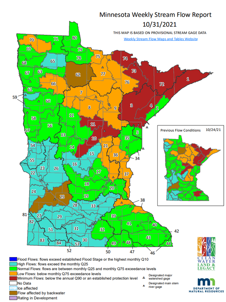 Weekly stream flow maps and tables
Streamflow situation:
- Watersheds at minimum flow (below Q90): Eight watersheds (Mississippi River – Brainerd, Pine River, Rainy River – Headwaters, Vermillion River, St. Louis River, Cloquet River, Rainy River – Rainy Lake, and Lake Superior-North).
- Watersheds at low flow: 12 watersheds are experiencing low flow.
- Watersheds at normal flow: 37 watersheds are experiencing normal flow conditions.
- Watersheds at high flows: 23 watersheds are experiencing high flows.
Streamflow management actions:
- 96 surface water appropriation permits are currently suspended across 21 watersheds including the St. Louis River, Mississippi River – Brainerd, Pine River, Crow Wing River, Redeye River, Rapid River, Rainy River – Baudette, Sand Hill River, Little Fork River, Rainy River – Headwaters, Big Fork River, Rainy River – Manitou, Mississippi River – Grand Rapids, Red Lake River, Clearwater River, Thief River, Roseau River, Two River , Mississippi River – St. Cloud, Mississippi River – Lake Pepin, and Watonwan River watersheds.
- One watershed dropped below the Q90 within the last week. One watershed increased above the local Q90 this week.
- Permit reinstatements following temporary suspension due to minimum flows:
- Watonwan River (No. 31): 15 surface water appropriation permits were reinstated on November 3, 2021.
- Roseau River (No. 71): 1 surface water appropriation permit was reinstated on November 3, 2021.
- Thief River (No. 65): 1 surface water appropriation permit was reinstated on November 3, 2021.
- Rapid River (No. 78) and Rainy River - Baudette (No. 79): 4 surface water appropriation permits were reinstated on November 3, 2021.
- Red Lake River (No. 63): 14 surface water appropriation permits were reinstated on November 4, 2021.
- Sand Hill River (No. 61): 8 surface water appropriation permits were reinstated on November 4, 2021.
- Crow Wing River (No. 12) and Redeye River (No. 13): 17 surface water appropriation permits were reinstated on November 4, 2021
- Lake Superior – North (No. 1): 2 surface water appropriation permits were reinstated on October 14, 2021.
- Snake River (No. 36) and Lower St. Croix River (No. 37): 16 surface water appropriation permits were reinstated on October 7, 2021.
- Clearwater River (No. 66): 7 surface water appropriation permits for wild rice irrigation were reinstated on September 20 for implementation of the Clearwater River Wild Rice Irrigation Allocation Plan by the Red Lake Watershed District. The plan states wild rice irrigators will be allowed to flood fields during specific flow regimes of the river above the minimum flow threshold (Q90).
- Wild Rice River (No. 60): 6 surface water appropriation permits were reinstated on September 10.
- Mississippi River – Sartell (No. 15) and Sauk River (No. 16): 42 surface water appropriation permits were reinstated on September 9, including four surface water appropriation permit holders that were implementing their contingency plan.
- Bois de Sioux River (No. 54) and Mustinka River (No. 55): 8 surface water appropriation permits were reinstated on September 8.
- Other permit actions in watersheds at minimum flow (below the Q90) include:
- Mississippi River – Lake Pepin (No. 38): 9 surface water appropriation permits were suspended on August 25. Flows at the designated stream flow gage in Empire continue above the Q90.
- Mississippi River – St. Cloud (No. 17): 25 surface water appropriation permits were suspended on August 24. Four surface water appropriation permit holders are implementing their contingency plan through the use of a groundwater well in lieu of their surface water appropriation. Flows at the designated stream flow monitoring gage near Big Lake continue above the Q90.
- Two River (No. 70): 3 surface water appropriation permits were suspended on August 4. Flows at the designated stream flow gage at Lake Bronson continue above the Q90 this week.
- Clearwater River (No. 66): 14 surface water appropriation permits were suspended on August 4. Flows at the designated stream flow gage at Plummer continue above the Q90.
- Little Fork River (No. 76): 3 surface water appropriation permits were suspended on July 28. Flows at the designated stream flow monitoring gage at Littlefork continue above the Q90.
- Rainy River – Headwaters (No. 72): 1 surface water appropriation permit was suspended on July 28.
- Rainy River – Manitou (No. 75) and Big Fork River (No. 77): 2 surface water appropriation permits were suspended on July 28. Flows at the designated stream flow monitoring gage at Big Falls continue above the Q90.
- Mississippi River – Grand Rapids (No. 9): 19 surface water appropriation permits were suspended on July 27. Flows at the designated stream flow monitoring gage at Grand Rapids continue above the Q90.
- Mississippi River – Brainerd (No. 10) and Pine River (No. 11) watersheds: 21 surface water appropriation permits were suspended on July 13.
- Louis River (No. 3) and Cloquet River (No. 4) watersheds: 6 surface water appropriation permits were suspended on July 11. Additionally, 3 permits have contingency plans to modify their appropriation under the existing permits.
- The Vermillion River (No. 73) and Rainy River – Rainy Lake (No. 74) watersheds include only two non-consumptive water-use permits, resulting in no suspensions.
- The Lake of the Woods (No. 80) watershed does not have any surface water appropriation permits.
- The DNR will reinstate permits when the average daily flow exceeds, for at least 72 hours, the Q90 plus the cumulative instantaneous total of all suspended appropriations from contributing surface water sources within the watershed. Consideration of anticipated precipitation or lack thereof is also a factor in determining when to reinstate suspended permits.
- We continue to watch the changing streamflow conditions and suspend or reinstate surface water appropriation permits where and when necessary.
Mississippi River dams
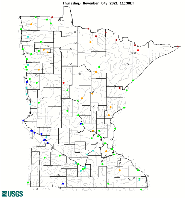 USGS map of stream flow locations including Mississippi River dams
Mississippi River dams situation:
- Mississippi River low flow plan is no longer in effect.
- One gage had flow below the trigger flow as of noon on Wednesday.
- Grand Rapids 728 cfs (trigger 400 cfs)
- Brainerd 1860 cfs (trigger 900 cfs)
- Royalton 3620cfs (trigger 1500 cfs)
- Cloud 4650 cfs (trigger 1700 cfs)
- Brooklyn Park 5590 cfs (trigger 2300 cfs)
- Other
- Precipitation from this week has cause all gage to trend upward.
Management actions:
- Notable low flow fluctuations
- November 1- Pokagama- Increased outflow by 200 cfs
- Communications
Fire Danger and Management
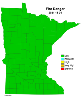 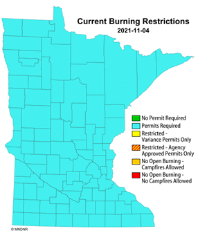 Statewide fire danger and burning restrictions
Fire Danger Analysis and Recommendations:
(Fire danger conditions can change daily based on local meteorological variables. Information presented illustrates a real-time snap shot of current conditions on November 4.)
- Counties with Extreme Fire Danger: 0
- Counties with Very High Fire Danger: 0
- Counties with High Fire Danger: 0
- Fire management actions:
- As of November 4, fire danger is low across the state.
- As of November 4, burning permits are still required in all counties. There are no other designated burning restrictions.
Lake Water Levels
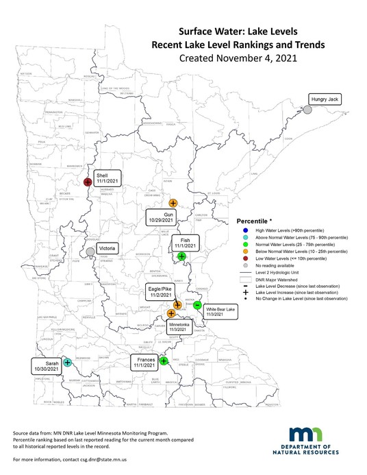 Analysis and Recommendations
Lake Level situation depicted on the above map:
- One of the eight reporting lakes decreased 0.36 inches from the previous week.
- Seven of the eight reporting lakes increased from the previous week, from 0.24 to 0.96 inches.
- One of the eight lakes is in the low range.
- Three of the eight lakes are in the below normal range.
- Three of the eight lakes are in the normal range.
- One of the eight lakes is in the above normal range.
The DNR LakeFinder non-mobile website provides available lake level elevations for individual lakes. Search by county, the lake’s name or eight-digit identification number for your lake, and then click on the Water Levels report. The Lake Water Level report page contains all available lake levels, highest and lowest lake levels, and a 10-year graph. All the reported historic and current lake elevations can be downloaded for viewing or copied to a spreadsheet for graphing and other functions.
Precipitation Forecast
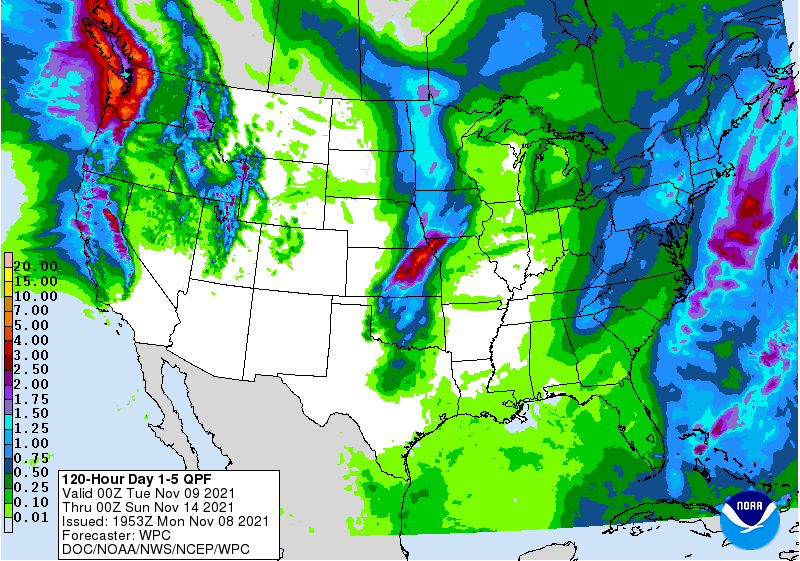 Analysis
- As Of November 8, 2021, the Quantitative Precipitation Forecast from NOAA’s Weather Prediction Center indicates light to moderate precipitation across Minnesota over the next five days.
- For updated forecasts, see the NOAA National Prediction Center quantitative precipitation forecasts.
|