Learning from the Landscape
Both time and scale are important for discerning change occurring on our landscapes. Although we might not realize it, we use both of these almost every day - when we review the weather for our hometown.
 |
|
By way of illustration, let’s view images of a weather radar.
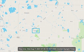
Frederick, Wisconsin and immediate area; 7:40a, August 11th, 2021.
Immediate area shows no threats on a clear morning, no worries for the drive to work.
|
 |
|
Expanded scale of view; 7:40a, August 11th, 2021
Just beyond the immediate horizon, a storm is traveling toward Fredrick.
By changing the scale, now you ask; how severe, how fast and how large is this system?
|
 |
|
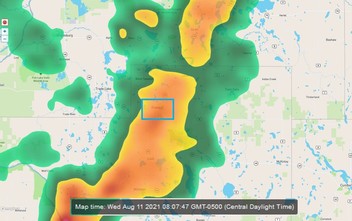
Advance time 27 minutes to complete the story; 8:07am, August 11th 2021
Frederick is now in the middle of the orange and red swath, engulfed in a summer storm. Did you see it coming?
How do we get better at preparing for storms brewing just over our time and space horizons?
|
In somewhat the same manner, we can examine our landscapes to learn about changes that have occurred over time and across scales. That context will help us prepare for future change. We will need to shift perspectives often, and to be nimble in response to emerging conditions that are always just over the horizon.
Looking back at landscapes
To understand changing conditions, it is important to look back and lay the foundation. It can be a challenge to envision how your landscape looked in the past and what changes have occurred. Here are some ways the WHAF can help.
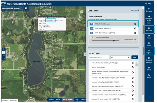
View Historic Data at a location
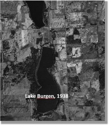
- Historic Aerial Images (1920s - 2000)
- Marschner Presettlement Vegetation (Land Cover 1890's)
To view Historic Aerial Images, open the map below.
- In the Add Data panel, click on 'Historic Aerial Images' layer name.
2. Open the Legend panel to see the date range for each dot color
3. Click on a 'dot' in the map to open the information box
4. Click the link in the box to view historic aerial image.
|
 |
|
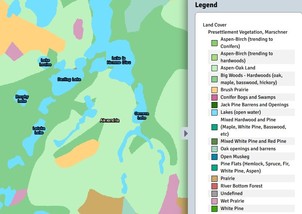
To view Pre-settlement Vegetation in the Alexandria area;
- Open the map on the left.
- Open the Add Data panel
- Click the Presettlement Vegetation, Marschner layer name.
- Click on the map to identify the vegetation type, or open the 'Legend' tool.
|
Continue Exploring
In today's world, the pace of change seems to accelerate along with the mountains of data keeping us 'informed'. All that information can help us better understand watershed health if it is delivered together with interpretation and historical context.
For more detail, open the Use Example: Exploring Change over Time - Alexandria, MN (pdf) that walks through these additional steps:
• Change spatial scale to look across watershed boundaries and place Alexandria at the headwaters of its watershed, an influential position for downstream health.
• Change time scale to look at pre-settlement vegetation and water features. Explore aerial photos of development from 1930’s to recent.
• Examine changes in WHAF Health Scores that confirmed that impervious surface expanded, perennial vegetation decreased, and more water was used.
• Review the historic climate record for Long Prairie major watershed, showing a shift toward more annual precipitation and warmer temperatures, particularly in the winter.
The Importance of Time and Scale
Like many places in Minnesota, the Alexandria area has experienced intense change in the way land and water resources are used. These changes can create watersheds that are out-of-sync with the balance and rhythm of the historic system. Knowing how the landscape looked and functioned in the past is important information as we seek to implement innovative actions that rebuild a balanced, healthy system with the resilience to withstand the inevitable changes of the future.
NEW Use Examples
Exploring Watersheds with WHAF
With so many tools, health scores, charts and data layers - how do you explore watersheds with the WHAF and not get lost in the weeds?
We know using the resources in the WHAF can be a little daunting, so a new page of Use Examples has been added to our website. The examples are organized by topic to help you choose those that are most related to your work. Under each topic are pdfs that can be downloaded and links to other related resources.
Use Example Topics
Do you have an example of using the WHAF that would benefit others to hear about? Do you have a topic area you would like us to add?
Send us your ideas and suggestions, we want to share the learning and keep building our library of Use Examples.
|
|
 |
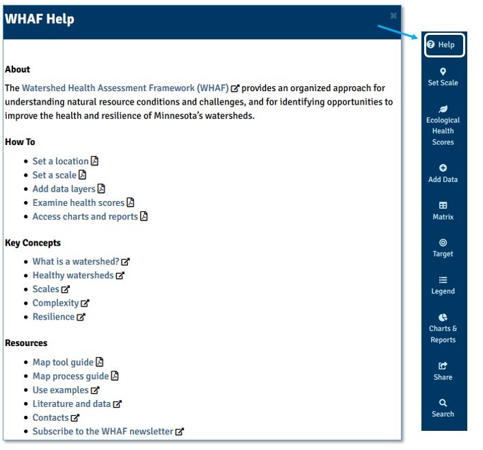
Help Menu in the Map
 |
|
And a reminder; we recently added this help menu in the WHAF Map. It is always at the top of the map tools; easy to find and easy to use.
We hope these changes provide better support for our users as you explore your watershed.
|
|