Weekly Drought Update - August 16, 2021
Key Messages in this Update
- Drought situation:
- As of August 10, 2021, 95% of the state is experiencing at least Moderate Drought (D1), 78% of the state is experiencing at least Severe Drought (D2), 42% is experiencing at least Extreme Drought (D3) and seven percent of the state is experiencing Exceptional Drought (D4). This is the first time Minnesota has experienced Exceptional Drought since the Drought Intensity Classifications were implemented in 2000.
- The DNR is operating in the Drought Warning Phase of the Statewide Drought Plan Matrix.
- Streamflow situation:
- 30 out of 81 total major surface water watersheds are below the Q90, including two watersheds that dropped below their respective Q90 (minimum flow) this week. Five watersheds have experienced increased flows and are now above the minimum flow (Q90) threshold after being below in the previous week.
- Fire danger situation:
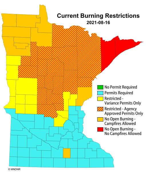
- As of August 12, 2021, burning permits are still required in all counties. Burning restrictions are in place in central and northeastern Minnesota.
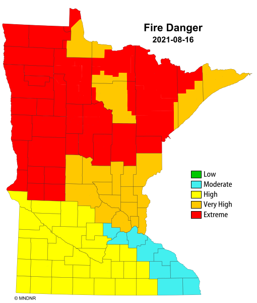
- As of August 12, 2021, fire danger is extreme over much of the west central counties and high to very high over much of the northern half of the state.
- Lake Level situation:
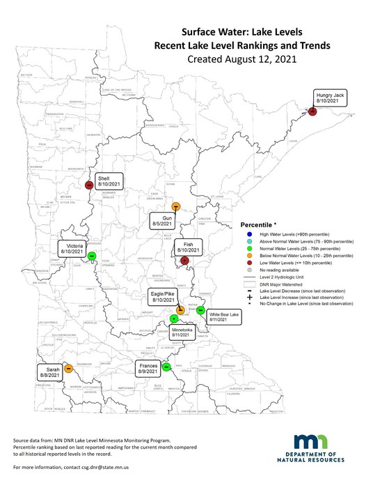
- Eight of the ten selected lakes decreased from the previous week, from 0.12 to 0.84 inches.
- Two of the ten lakes stayed the same.
- Four of the ten lakes remain in the normal range
- Six lakes of the ten are in the low or below normal range.
Drought Information
Last two weeks of Drought Maps:
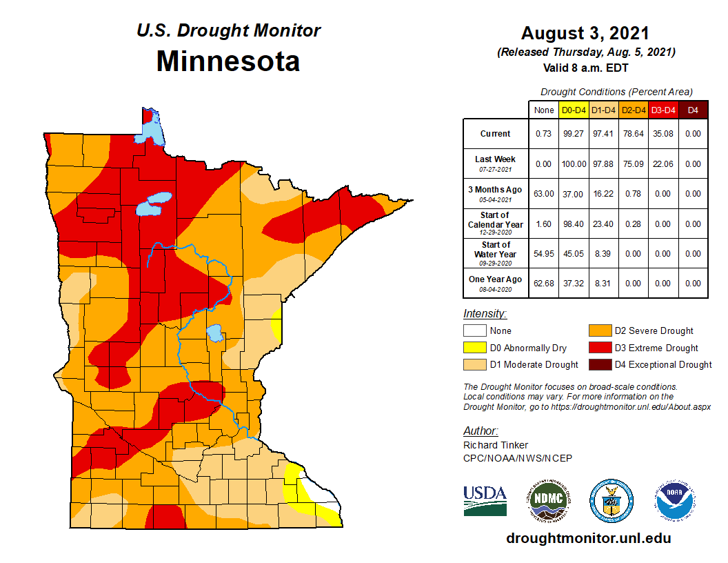 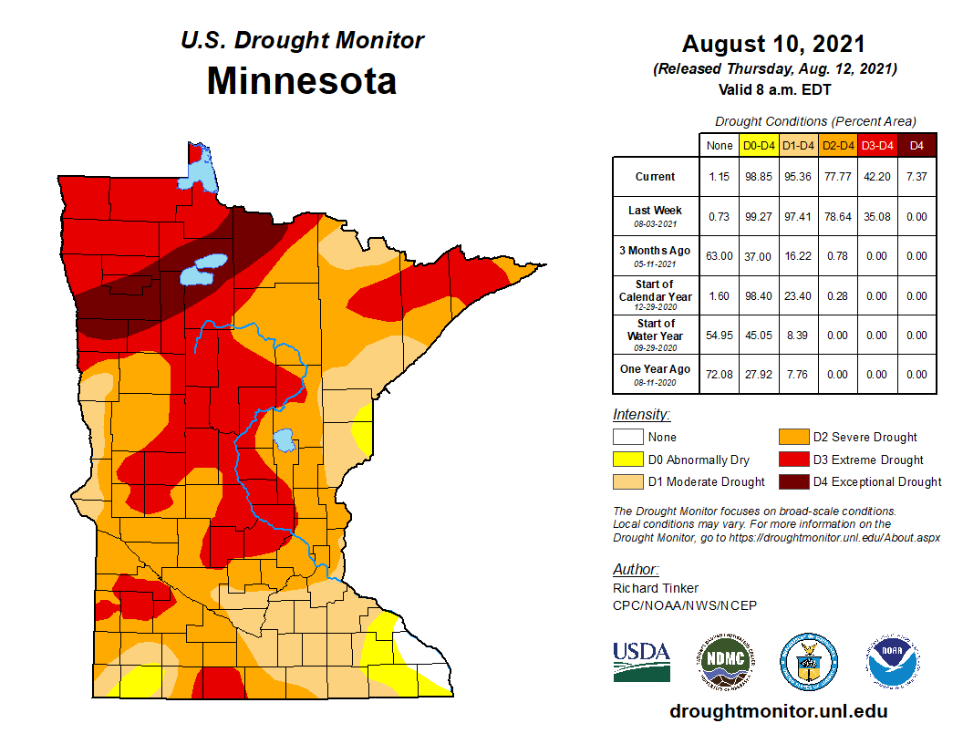 Link to the maps.
Drought Analysis:
- Counties in exceptional drought (D4): 9
- Counties in at least extreme drought (D3): more than 50
- Counties in at least severe drought (D2): more than 70
- Counties in at least moderate drought (D1): All counties except for two have at least some moderate drought.
- Counties just abnormally dry (D0 – not drought): 2
- Estimated population in Drought Areas: 5,066,279
Streamflow Information
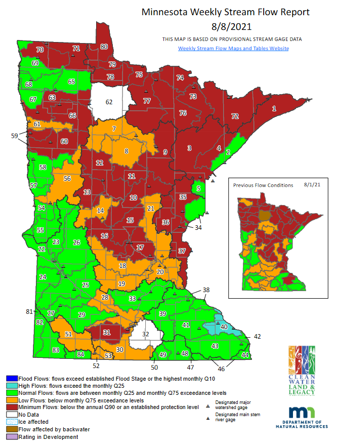 Link to the map.
Streamflow Analysis:
- Watersheds at minimum flow (below Q90): 30, including three new watersheds dropping below their respective Q90 this week: Watonwan River (No. 31), Kettle River (No. 35), and Two River (No. 70). Increasing above Q90 this week are 8 watersheds, including: Zumbro (No. 41), Mississippi River & Lake Pepin (No. 38), Mississippi River (No. 20), Tamarac/Joe River (No. 69), Snake River (No. 68), Grand Marais Creek (No. 67), Thief River (No. 65), and Sandhill River (No. 61).
- Watersheds at low flow: 21 watersheds are experiencing low flow
- Watersheds at normal flow: More than 27 watersheds are experiencing normal flow conditions.
- Watersheds at high flows: One watershed is experiencing high flows.
Fire Danger
  Link to the maps.
Fire Danger Analysis:
(Fire danger conditions can change daily, based on local meteorological variables. Information presented illustrates a real-time snap shot of current conditions on August 16)
- Counties with Extreme Fire Danger: 30
- Counties with Very High Fire Danger: 21
- Counties with High Fire Danger: 32
- As of August 16, 2021, fire danger is extreme over much of the west central counties and very high over much of the northern half of the state. While the south western part of the state figure danger is high.
- As of August 16, 2021, burning permits are still required in all counties. Burning restrictions are in place in central and northeastern Minnesota.
- See Superior National Forest webpage for current fire information.
Lake Water Levels
 Sample Lake Level Analysis
- Eight of the ten selected lakes decreased from the previous week, from 0.12 to 0.84 inches.
- Two of the ten lakes stayed the same.
- Four of the ten lakes remain in the normal range.
- Six lakes of the ten are in the low or below normal.
- Shell Lake in Becker County reported its lowest lake level.
|
|
|