Weekly Drought Update - August 2, 2021
Key Messages in this Update
- Drought situation:
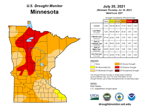
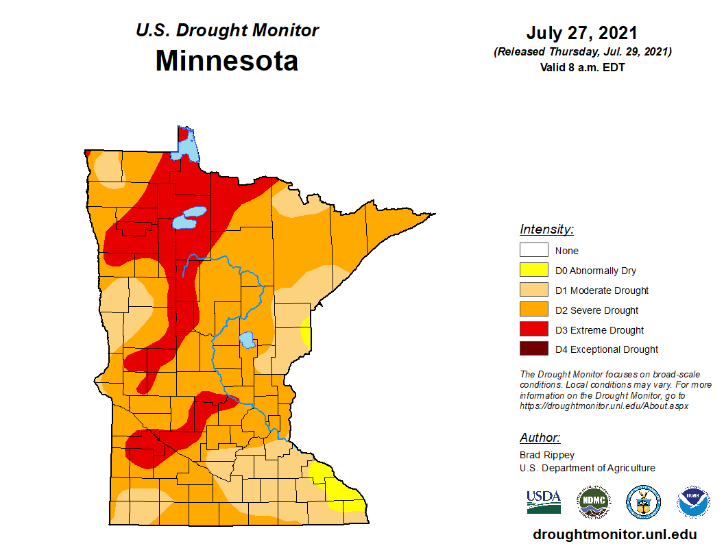
- As of July 27, 98% of the state is in Moderate Drought (D1) or worse, 75% of the state is in Severe Drought (D2) or worse, and 22% is in Extreme Drought (D3).
- The DNR is operating in the Drought Warning Phase of the Statewide Drought Plan Matrix.
- Streamflow situation:
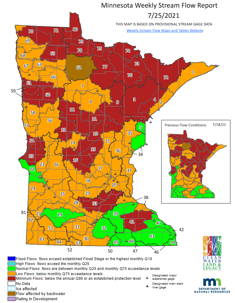
- 28 out of 81 total major surface water watersheds are below the minimum flow (Q90) threshold, including two watersheds that dropped below their respective Q90 thresholds this week. Five watersheds have experienced increased flows and are now above the Q90 threshold after being below in the previous week.
- Fire danger situation:
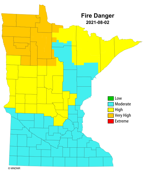
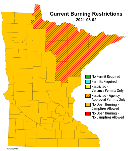
- As of July 27, in most north central and northeast counties, no campfires are allowed anywhere on DNR lands, including state parks. Charcoal grills are prohibited. Gas camp stoves are still allowed.
- As of July 29, fire danger is high over much of the northwestern, central and northeastern counties.
- Lake Level situation:
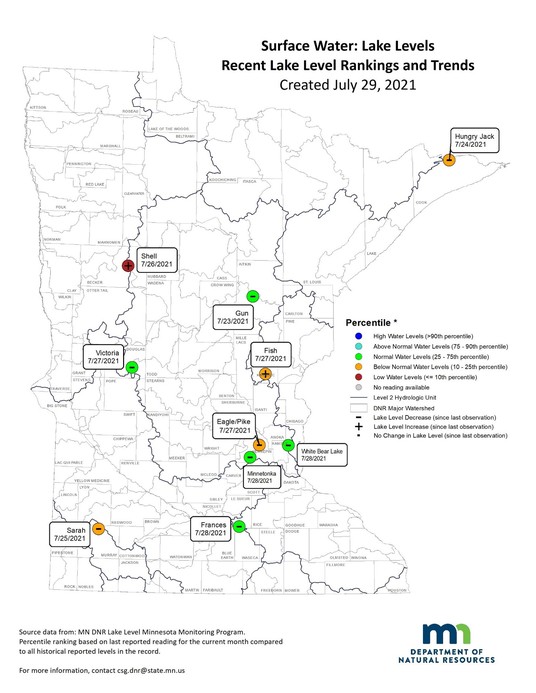
- Eight of the ten selected lakes decreased from the previous week, from 0.24 to 1.68 inches.
- Two of the ten lakes increased, from 0.12 to 0.36 inches.
- Five of the ten lakes remain in the normal range, with half showing low or below normal.
Drought Information
Last two weeks of Drought Maps:
  Link to the maps.
Drought Analysis:
- Counties in exceptional drought (D4): 0
- Counties in extreme drought (D3): 30
- Counties in severe drought (D2): More than 60
- Counties in moderate drought (D1): All counties have at least some moderate drought or worse.
- Counties just abnormally dry (D0 – not drought): 0
- Estimated population in Drought Areas: 5,204,626
Streamflow Information
 Link to the map.
Streamflow Analysis:
- Watersheds at minimum flow (below Q90): 28, including two new watersheds dropping below their respective Q90 this week: Minnesota River – Shakopee (33) and the Zumbro River (41). Removed from Q90 this week are five basins including: Kettle River (No. 35), Snake River (No. 36), Upper St. Croix River (No. 34), Lower St. Croix River (No. 37) and the Nemadji River (No. 5).
- Watersheds at low flow: 37 watersheds are experiencing low flow.
- Watersheds at normal flow: 15 watersheds are experiencing normal flow conditions.
- Watersheds at high flows: No watersheds are experiencing high flows.
Fire Danger
  Link to the maps.
Fire Danger Analysis:
(Fire danger conditions can change daily, based on local meteorological variables. Information presented illustrates a real-time snap shot of current conditions on July 29)
- Counties with Extreme Fire Danger: 0
- Counties with Very High Fire Danger: 7
- Counties with High Fire Danger: More than 30
- As of July 27, in most north central and northeast counties, no campfires are allowed anywhere on DNR lands, including state parks. Charcoal grills are prohibited. Gas camp stoves are still allowed.
- As of July 29, fire danger is high over much of the northwester, central and northeastern counties.
- As of July 29, burning permits are still required in all counties. Burning restrictions are in place in northcentral and northeastern Minnesota.
- See Superior National Forest webpage for current fire information.
Lake Water Levels
 Sample Lake Level Analysis
- Eight of the selected lakes decreased from the previous week, from 0.24 to 1.68 inches.
- Two of the ten lakes increased, from 0.12 to 0.36 inches.
- Five of the ten lakes remain in the normal range.
- One lake is low and four lakes are below normal.
|
|
|