|
March 29, 2021

Our 2021 virtual Spring Series has begun!
Join us for the remainder of our "series" of one-hour learning experiences on a wide variety of floodplain and shoreland management topics.
Target audience: Local zoning and engineering officials, consulting engineers and planners, watershed officials, surveyors, state and federal agency staff involved in related programs, etc. Many sessions would also be of interest to elected/appointed officials and other interested citizens.
It's not too late to register for the remaining topics!
|
Upcoming Topics and Registration Links
- Mon, March 29, 1-2 pm: Shorelands – Aiming Higher! Registration Link for 3/29/2021
- Wed, March 31, 9:30-10:30 am: Floodplain Administration-the Next Step! Registration Link for 3/31/2021 – 9:30 am
- Wed, March 31, 1-2 pm: Floodplain Basics (repeat of March 8th) Registration Link for 3/31/2021 – 1:00 pm
- Mon, April 5, 1-2 pm: Mitigation Mindset Registration Link for 4/5/2021
- Wed, April 7, 9:30-10:30 am: Floodplains - Aiming Higher! Registration Link for 4/7/2021
- Mon, April 12, 1-2 pm: FEMA Maps – Dealing with “A Zones” Registration Link for 4/12/2021
- Wed, April 14, 9:30-10:30 am: Web Sites, Floodplain Maps and Tools - Oh My! Registration Link for 4/14/2021
- Mon, April 19, 1-2 pm: Variance Administration-A Focus on Shoreland Registration Link for 4/19/2021
- Wed, April 21, 9:30-10:30 am: STOP LOOK and LISTEN! Flood Prep & Response Registration Link for 4/21/2021
- Mon, April 26, 1-2 pm: Dealing with Non-Conformities (Shoreland and Floodplain) Registration Link for 4/26/2021
- Wed, April 28, 9:30-10:30 am: Money, Money, Money…..Flood Insurance Basics and Coming New Changes! Registration Link for 4/28/2021
- Mon, May 3, 1-2 pm: Shoreland Management 101 Registration Link for 5/3/2021
- Wed, May 5, 9:30-10:30 am: Variance Administration-A Focus on Shoreland Registration Link for 5/5/2021
For more information
Please contact floodplain.dnr@state.mn.us or:
Ceil Strauss, MN DNR State Floodplain Manager
Dan Petrik, MN DNR Shoreland & River Programs Manager
See our Spring Series flyer for more details.
 By Mary Juhl, Board of Water and Soil Resources (BWSR) Communications Coordinator
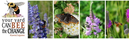
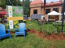
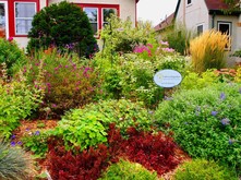
Lawns to Legumes Pilot Program
The Lawns to Legumes Pilot Program strives to increase pollinator habitat by providing Minnesotans with the tools they need to create habitat in their yards. Since fall 2019, the program has offered ecological gardening workshops, coaching, cost-share funding and planting resources to Minnesotans who want to incorporate pollinator-friendly native plants into their home landscaping.
 |
|
The Minnesota Board of Water and Soil Resources (BWSR) administers the pilot program with assistance from Blue Thumb – Planting for Clean Water and Metro Blooms. Funding is provided by the Environment and Natural Resources Trust Fund. |
Program Status
Lawns to Legumes has been recommended for additional funding this legislative session, with a decision expected by late May. Cost-share funding opportunities are currently closed until additional funding is secured, but the program continues to offer a wide range of resources to Minnesotans interested in pursuing pollinator habitat projects.
|
|
 |
Resources include:
-
BWSR's Planting for Pollinators Habitat Guide is an in-depth guide intended to help gardeners plan, implement, and maintain pollinator habitat projects.
- Pollinator Garden Templates: These templates provide base designs for native plant pollinator gardens, including boulevard and shade garden designs. They are customizable with substitutions for each plant.
- BWSR Ecological Gardening Blog posts:
Browse additional resources on the Lawns to Legumes webpage.
 |
|
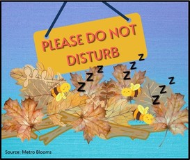
Don't "Clean Up" too early in the season
If you are planning to garden this spring, please note that many pollinators overwinter by taking shelter in dead plant material in your yard. For this reason, don’t rake or otherwise disturb dead leaves and other plant matter until temperatures consistently reach 50 degrees, or until you start seeing dandelions!
|
By Jim Berg, DNR County Geologic Atlas Program
History
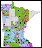
The Minnesota Groundwater Provinces map appeared online 20 years ago as a way of explaining the uneven distribution of aquifers in the state. This is one of the mostly widely referenced and used documents in the County Atlas Program. It is has been included in publications by many other organizations from Minnesota Well Owners Organization (MNWOO) to Freshwater, and used by educators at all levels of instruction.
One of my first projects with the DNR was planning and logging exploratory drilling sites in the southwestern part of the state. During and after that project, I found myself in meetings struggling to explain why that drilling was needed to people who were unaware of the groundwater quantity challenges of that region. The provinces map was created to fulfill that educational need. Since that time, the Minnesota Geological Survey has made tremendous progress refining much of the geology used in the province map. The Minnesota Groundwater Provinces 2021 has been updated to reflect those improvements. Changes include, shifted boundaries, added detail, and improved province characterizations.
Minnesota Groundwater Provinces
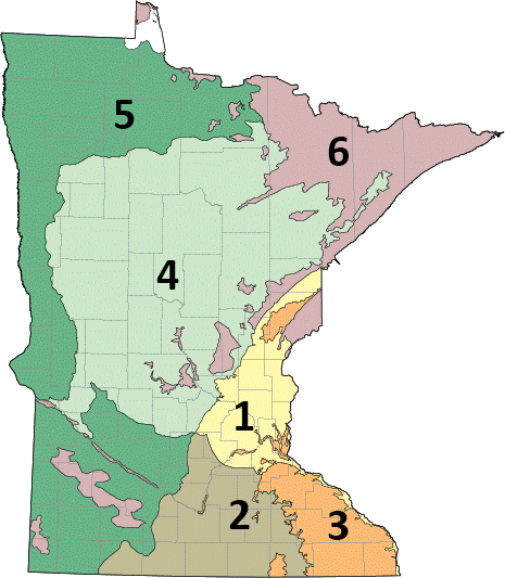
Minnesota is generally considered to have abundant water resources. But groundwater resources are not evenly distributed across the state. The Groundwater Provinces map summarizes aquifer and groundwater resource differences at the regional level. The occurrence of groundwater in Minnesota is related primarily to local geologic conditions that determine the type and properties of aquifers.
How do the provinces differ?
Each of the provinces has a unique combination of aquifer characteristics that affect water availability.
|
 |
|
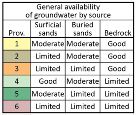
The table to the left shows general groundwater availability by province for different groundwater sources. The table shows that some parts of the state have several groundwater resources to choose from, while other parts of the state may have only limited groundwater resources available. Water resource planners, managers, and users should recognize these differences when evaluating groundwater resources for future use. |
Resources
A PDF of the map, associated cross sections, and GIS file can be downloaded at:
https://www.dnr.state.mn.us/groundwater/provinces/index.html
The Association of State Floodplain Managers (ASFPM) announced their annual conference will be virtual again in 2021.
ASFPM had great success with their virtual conference in 2020, and are planning an even better experience for the 2021 virtual conference. The full virtual program will be posted soon, and registration will open in February. Check the ASFPM conference website for updates!
|
Reminder: Scholarships available from MnAFPM for local officials to attend ASFPM conference
Scholarships are widely available for those who may need one. Budgets for training opportunities may be tight this year, but registration costs are not a reason to miss out!
For more information, including the scholarship application, please visit the MNAFPM website at www.mnafpm.org.
|

The next Coastal Hazards of Superior (CHAOS) is coming soon. Register to join us on Thursday, April 15, 10 – 11:30 am.
Meeting Description
Are you planning a shoreline project? This meeting features a panel of regulatory and engineering experts who will share their insights about how to successfully prepare for shoreline work on your property or in your community. Not sure what project is right for you? We’ll talk about the new Great Lakes Coastal Adaptation Menu as a tool that can help you identify steps to take to adapt your property for changing conditions. Our April meeting marks one year since CHAOS was started. We’ll also have time to network and provide feedback on how CHAOS is structured.
|
Guest speakers:
-
Crystal von Holdt, Water Management Specialist, Wisconsin Department of Natural Resources
-
Patricia Fowler, Area Hydrologist, Minnesota Department of Natural Resources
-
Zac Morris, Twin Cities Marine Manager, AMI Consulting Engineers
-
Kristen Schmitt, Climate Change Adaptation Specialist, Northern Institute of Applied Climate Science
-
Danielle Shannon, USDA Northern Forests Climate Hub Coordinator, Northern Institute of Applied Climate Science
The CHAOS Community of Practice is a learning hub about coastal hazards that affect Minnesota and Wisconsin’s communities. Membership in the community is free and open to anyone with an interest learning and sharing about coastal hazards and resiliency. For more information, please reach out to Melanie Perello at Minnesota’s Lake Superior Coastal Program.
Register for the meeting:
https://uwmadison.zoom.us/meeting/register/tJMvceuhrjkrHtDM0sZCbXnLtEWDMRjNloj0

FEMA continues to chip away at updating their technical bulletin series. The latest are updates of the 1993 Technical Bulletin and the 1993 Technical Bulletin 6.
NOTE: These technical bulletins cover national minimums and standards. There may be higher state and/or local standards. Always check with your local zoning office and building officials.
|
 |
|
Technical Bulletin 3: Non-Residential and Mixed Use Floodproofing - Requirements and Certification (2021)
Provides guidance on the NFIP regulations concerning watertight construction and the required certification for flood proofed non-residential buildings in Zones A, AE, A1-A30, AR, AO, and AH whose lowest floors are below the Base Flood Elevation.
See FEMA Technical Bulletin 3 (2021).
|
Technical Bulletin 6: Requirements for Dry Floodproofed Below-Grade Parking Areas Under Non-Residential and Mixed Use Buildings (2021)
Provides guidance on the NFIP regulations concerning the design of below-grade parking garages beneath buildings located in Zones A, AE, A1-A30, AR, AO, and AH.
See FEMA Technical Bulletin 6 (2021).
|
|
 |
By Paul Putzier, DNR Groundwater Unit Supervisor
Background
Groundwater is one of the most valuable, often overlooked, and misunderstood natural resources. Our state is placing more demands on our groundwater each year. The challenge to balance wise use and protection will only increase over time.
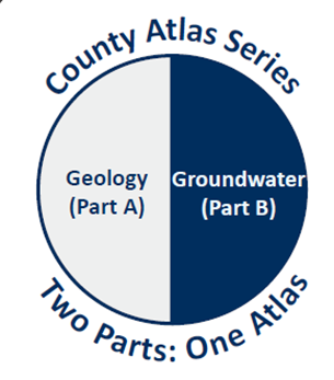
What's In a County Atlas?
The atlas provides comprehensive geologic and groundwater mapping and associated information for planners, managers, scientists, researchers and individuals statewide for a wide variety of projects such as: water supply planning, land use decisions, resource development, resource protection, transportation planning, agricultural water supply, groundwater research/studies, and Environmental Impact Statements.
There is one atlas, made up of two parts. The County Atlas, including the County Geologic Atlas completed by the Minnesota Geological Survey (MGS), and the County Groundwater Atlas completed by the DNR, is one important tool for professional planners, resource managers and researchers to help make critical informed judgments. Our goal is a complete County Atlas for all Minnesota counties as soon as possible.
|
Use at County and Local Level
One example of how the atlas is being used came from Stacey Stark, University of Minnesota-Duluth. She said “We use the groundwater atlas to make maps to support content in county Hazard Mitigation Plans, as required by FEMA to receive federal mitigation program dollars/funds. We facilitate the update of these plans for almost half of all Minnesota counties. Without the groundwater atlas, we would not have easy access to information about groundwater sensitivity and would likely leave this out of the plan. One of our goals is to outline potential hazards and assemble resources for them to address mitigation actions. Perhaps the most valuable is to get information in the hands of others for future planning and education.”
Another example came from, Rob Vix, Drilling Manager, Cascade Environmental, “For agriculture projects, the atlas helps when looking for potential high capacity wells or difficult sites by giving us some ideas of how much unconsolidated geology and groundwater is available for sustainable water use.”
Current Atlas Publication Status
COVID slowed the Atlas Program down in 2020, but the MGS and DNR have published a number of county atlases recently, and plan to publish more in 2021.
Recent Groundwater Atlas (Part B) publications have included Meeker, Morrison, Washington, Redwood, Brown, and Kanabec. Expected 2021 publications of Groundwater Atlases include Winona, Houston, and Hennepin counties. The MGS continued to publish County Geologic Atlases (Part A), including Hennepin, Olmsted, Kandiyohi, Dodge, Rock, and Nobles. See the status maps for the MGS and DNR.
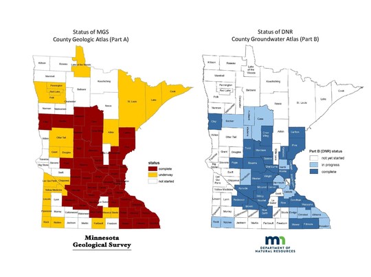 In addition, the following counties have recently requested an atlas and agreed to provide “in-kind” support required by DNR: Lake of the Woods, Roseau, Scott, Swift, Lyon, Koochiching, Ramsey, Stevens, Freeborn, and Murray. The MGS will be starting work in all these counties soon.
For More Information
See DNR's County Atlas Status List page for the latest Part A and Part B status maps, and links to available county atlases.
Survey of Coastal Management Needs for Local Governments on the Great Lakes and St. Lawrence River
Local elected officials and staff are encouraged to fill out the survey at following link to help guide future coastal protection efforts.
Survey Link: https://illinoisaces.co1.qualtrics.com/jfe/form/SV_87VZn1JGTb5v1SS
Response Deadline: Friday, April 30
Survey Purpose
The Great Lakes and St. Lawrence Cities Initiative and its partners are assessing needs facing U.S. and Canadian local and tribal governments on the Great Lakes and St. Lawrence River related to coastal management and resilience to impacts such as erosion from changing water levels, flooding, and severe storm events. The survey results will guide efforts to help communities safeguard resources in coastal areas.
Who Should Complete the Survey
The survey is intended for both elected officials and staff in local units of government, as well as Tribal Authorities and First Nations, with authority for coastal areas along the Great Lakes and the St. Lawrence River in the United States and Canada. This includes cities, villages, counties, townships, regional planning agencies, port authorities, park districts or other entities with government authority along the coastline. We encourage multiple respondents from a single jurisdiction, including elected officials (mayors, county supervisors) and staff working on coastal issues (city managers, planning directors, etc.).
Time Commitment
The survey should require approximately 15 minutes to complete. You do not need to complete it in one sitting.
For More Information
If you have questions or would like to receive a summary of the survey results, please contact Jon Altenberg, Executive Director, Great Lakes and St. Lawrence Cities Initiative, jon.altenberg@glslcities.org.
Survey Sponsors
Past, scheduled, and anticipated dates since January 2021 Water Talk |
|
 |
Preliminary Maps
- May 2021: Carlton, Dodge, Morrison, and Wabasha Counties (anticipated)
Local Officials Meetings & Open Houses*
- Carlton County (St. Louis River watershed portion): Local Officials Flood Risk Review Meeting - 2/22/2021; 2 pm (with St. Louis County)
- Koochiching County: Open House - 3/23/2021; 5-7 pm
- Lake of the Woods County: Open House - 2/18/2021; 4-6 pm
- Murray County: Kick-off Meeting - 2/23/2021; 10:30 am
- Olmsted County (panels): Open House - 2/23/2021; 2-4 pm
- St. Louis County (countywide for riverine flooding, and St. Louis River watershed): Local Officials Flood Risk Review Meeting - 2/22/2021; 2 pm
- Waseca County: Flood Risk Review Meeting for Local Officials - 3/23/2021; 1 pm
- Watonwan County: Open House - 2/23/2021; 5-7 pm
- Twin Cities Mississippi River HUC8 (portions of Anoka, Carver, Dakota, Hennepin, Ramsey, and Washington Counties) - Local Official Flood Risk Review Meetings:
- Bassett Creek Water Management Commission (WMC) - 2/24/2021 pm
- Ramsey Washington Watershed District (WD) - 3/4/2021 am
- Rice Creek WD - 3/11/2021 am
- Shingle Creek WD - 4/1/21 am
- Elm Creek WD - 4/13/2021 pm
- Minnehaha Creek WD - 4/15/2021 pm
- West Mississippi WD - 4/22/2021 am
- Coon Creek WD - 4/29/2021 am
*All meetings and open houses expected to be virtual until further notice.
90-Day Appeal Periods
- Pennington County - Dec. 9, 2020 to March 8, 2021
- Stevens County - Dec. 29, 2020 to March 29, 2021
- Rice County (panels) - March 3 to June 2, 2021
Letters of Final Determination (LFDs)
- Cottonwood County - March 24, 2021
- Yellow Medicine County - April 7, 2021 (anticipated)
Effective (6 months after LFD date)
- Scott County - Feb. 12, 2021
- Red Lake County - March 9, 2021
- Marshall County - March 23, 2021
- Cottonwood County - Sept. 24, 2021
Additional Map Update Information:
|