|
Sept. 29, 2020
By Carmelita Nelson, DNR, Water Conservation Consultant
Introducing the New Online Water Guardians Program!
Water Guardians is a new educational program developed by H2O for Life. Water Guardians is a free web-based curriculum consisting of five lesson plans that will take students on a journey from the start of the Mississippi River, down to the Gulf of Mexico, and off to other parts of the world. It teaches students about the global water crisis and how we can create change locally, together.
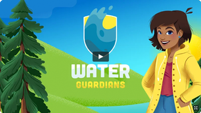
The program culminates in a service-learning component that will help engage students to become global citizens. You will find this program to be fun, engaging, and educational!
Check out the Water Guardians introductory video.
|
New Videos Highlight Groundwater and Nitrate Movement in Southeast Minnesota
The flow of groundwater in southeast Minnesota is fascinating and complex. In a new educational video series, the movement of groundwater is explored and brought to life. The unique approach combines realistic graphics, animation, and aerial footage of the region’s geology. High resolution graphics and short, two-minute animations are available.
Understanding Groundwater Movement, Especially in Karst Areas

By understanding how groundwater moves through the soil and various layers of bedrock, viewers can better understand how water-soluble contaminants like nitrate-nitrogen can enter drinking water wells and streams.
Although this project focuses on different landscapes in the Root River Watershed, the information can be applied throughout southeast Minnesota and Driftless Area of the Upper Midwest.
|
Links to short videos:
More Information
Go to www.mda.state.mn.us/segwresources to see three graphics, the video links (noted above) and other resources.
These educational materials are the result of a collaborative effort between partners including: Root River Field to Stream Partnership, Minnesota Geological Survey, county and state agencies, University of Minnesota Extension, and input from local well drillers, farmers, and rural homeowners.
Funding for this project was provided by the Clean Water, Land and Legacy Fund and a grant from the Minnesota Corn Research and Promotion Council.
By Dan Petrik, DNR, Shoreland and River Related Programs Coordinator
Improving Administration of Land Alteration Near Lakes and Rivers
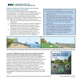
Several months ago the DNR released a fact sheet for homeowners on “What to do about fluctuating water levels on their property.” (See page from that fact sheet to the left.)
For most homeowners, filling and placing riprap or retaining walls are - in their mind - the logical choices for protecting their property. But these types of land alterations can also have significant negative impacts on shoreline resources, while not fixing the original problem.
As Minnesota’s climate experiences more frequent and extreme rain events, more sustainable approaches are needed to protect property and resources. Recently, the DNR released guidance that can be used as a comprehensive road map for how local governments can move forward in creating a more sustainable approach for regulating land alterations near water.
Potential Negative Environmental Impacts from Filling, Riprap and Retaining Walls
The risks from these types of land alteration are well known.
- Filling can alter runoff flow patterns, potentially causing neighbor conflicts and liability concerns.
- Filling wetlands removes water storage capacity increasing flood risk downstream and eliminates their function of filtering nutrients and sediment.
- Riprap and retaining walls designed to create an aesthetic edge for the water, rather than to solve an erosion problem can create erosion problems when water levels rise over their top and undermine them from behind.
|

Photo to right: High water can overtop riprap and undermine it from behind.
- Filling and land alteration kills existing deep-rooted vegetation and its ability to stabilize soil and buffer wave and ice action, creating more erosion problems.
- Riprap and retaining walls displace natural vegetation and habitat above and below the shoreline, and block the movement of turtles, ducks and mammals to and from the water.
|
Understanding Shoreland and Floodplain Ordinances
Land alteration activities are regulated by shoreland and floodplain ordinances. However, floodplain regulations only pertain to floodplains mapped by the Federal Emergency Management Agency (FEMA) and adjoining low areas. If there are no mapped floodplains in a shoreland district, then only the shoreland standards apply. If the shoreland district contains mapped floodplains, then both shoreland and floodplain standards apply. It is important to understand that local shoreland and floodplain ordinance provisions just meeting minimum state standards do not provide adequate protections for property and natural resources in the face of a changing climate.
Strengthening Protections through Better Administrator-Developed Conditions of Approval
Shoreland ordinances meeting minimum state standards contain few protection-specific standards, relying mainly on administrator-developed conditions of permit approval.
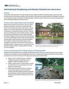
The new guidance document "Administering & Strengthening Lake Alteration standards near Lakes and River" (see cover page to the left) includes administrative tips for developing stronger administrator-developed conditions of approval on a variety of land alteration topics.
For example, when filling projects in the shore impact zone (SIZ), bluff impact zone (BIZ), or on steep slopes results in loss of vegetation, one tip encourages that vegetation be restored as a condition of permit approval. Another example suggests evaluating grading plans to ensure that proposed alterations limit runoff and do not affect neighboring properties.
The DNR recognizes that without current and specific permitting standards in the ordinance, it’s politically difficult for many communities to apply strong administrator-developed conditions of approval.
|
Adopting Stronger Ordinance Standards
Local governments can initiate efforts to examine the types of high water, erosion and other challenges in their community, and evaluate more long-term sustainable solutions. The new DNR guidance document includes a variety of “innovative” solutions to many of these problems.
Suggested ideas include design considerations such moving structures to higher ground or elevating structures in place on piers or filled stem walls instead of on a filled pad extending 15 feet.
By Pat Lynch, DNR, State Flood Hazard Mitigation Grant Program Manager
Since its establishment by the state legislature in 1987, Minnesota’s Flood Hazard Mitigation (FHM) Grant Assistance Program has awarded over half a billion dollars in state cost-share funds to local units of government to plan and implement a host of flood risk reduction measures around the state. From Anoka County to Yellow Medicine County, and from Afton to Zumbro Falls, local units of government large and small have partnered with the state and others to complete projects that significantly reduce flood risk and damage to public and private infrastructure, neighborhoods and businesses.
Types of Flood Risk Reduction Projects
Some of the more visible projects are for community-wide flood risk reduction. But other smaller and less visible projects have included:
- Buying out a cluster of frequently flood-damaged structures to create, or add to, park and open-space areas.
- Protection of essential community utilities, like water supplies.
- A number of projects also incorporate features that improve biodiversity and environmental conditions.
These investments in flood risk reduction create jobs and reduce the expense and stress of flood fighting and recovery. Recent study suggests that every dollar spent on riverine flood mitigation results in seven dollars in societal benefits.
Historical Project Funding
The lion’s share of funding for the FHM grant program is through bond appropriations of the Minnesota legislature. Typically the legislature considers a bonding (sometimes called public works) bill in even-numbered years. The DNR submits its request for funding to the governor in June of odd-numbered years for consideration the following legislative session. Some years the program receives what was requested, other years less, and some years more. Some years the legislature fails to agree on a bonding bill and the program receives no funding at all. This uncertainty of funding from one bond cycle to the next presents challenges to planning for and allocating funds to projects.
The graph below illustrates state flood hazard mitigation funding since 1988. It includes normal and line item program funding as well as state disaster appropriations for flood hazard mitigation. Of note is the downward trend in program funding since 2010.
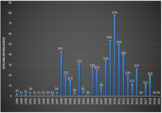 1988 - 2020 Flood Hazard Mitigation (FHM) Grant Program Funding by Minnesota Legislature
Status of Current Funding Requests
The DNR maintains a list of known current unfunded flood risk reduction needs as communicated to us by local units of government. Several on that list have begun construction on varying phases of the project and need additional state assistance to keep those projects advancing. Currently over 40 community and watershed district projects in various stages of planning, design or construction are included on the list. The estimated total state share for these projects exceeds $200 million.
The DNR’s bonding request to the legislature and governor for 2020 included $20 million for flood hazard mitigation. Those funds are intended to further or complete 14 community and watershed district flood risk reduction projects around the state. Absent the state providing financial assistance, most of those projects will be delayed, prolonging flood vulnerability to public and private property.
Over 30 Years of State Funding Assistance to Local Governments for Flood Risk Reduction
The FHM program has demonstrated its value to increasing flood resiliency in Minnesota for over 30 years. Much work has been done, but much remains. There is optimism that the legislature and governor continue to recognize the importance of the cost-share funding program that has benefited citizens all over the state; that recognition is reflected in continued funding of the important flood risk reduction work that remains.
If you have any questions about the Flood Hazard Mitigation Grant Assistance Program or have a project that may be eligible for consideration, please contact program manager Pat Lynch.
By Suzanne Rhees, Board of Water and Soil Resources (BWSR), Special Projects Coordinator
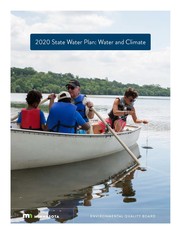
The 2020 State Water Plan was published by the Environmental Quality Board (EQB) in September 2020. The plan, which is required by state law, focuses on the intersection of Minnesota’s water resources and climate change.
Background
The purpose of the plan is to establish a framework for aligning state agencies, legislative priorities, and local government policy, programs and actions for the coming decade. EQB developed the plan to set an agenda for tackling the stubborn and complex water problems that climate change will intensify for Minnesotans. EQB convened state agencies, met with over 250 people from 44 public and private organizations, and conducted two informal surveys to learn about concerns related to water and climate and thoughts on what actions local and state government should take.
|
Image above: Cover of "2020 State Water Plan: Water and Climate"
Major Goals of Plan
The plan is centered on five major goals for mitigating the impact of climate change on water resources:
- Ensure drinking water is safe and sufficient
- Manage landscapes to protect and improve water quality
- Manage built environments and infrastructure for greater resiliency
- Manager landscapes to hold water and reduce runoff
- Promote resiliency in quality of life
Goals 3, 4 and 5 include recommendations of particular relevance to Water Talk readers.
Goal 3: Manage built environments and infrastructure for greater resiliency
Goal 3 of the plan recommends support modeling efforts and risk management that consider climate change impacts.
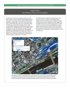
Communities can use FEMA’s “1%-plus” models and a new “Flood Factor” tool from the First Street Foundation to find areas more likely to flood due to climate change, compared to the 1%-annual-change (100-year) floodplain maps. As noted in the plan, the DNR Floodplain Program can assist communities learning to use the 1%-plus models and FEMA’s other new products, such as water depth grids or water velocity grids, to identify potentially vulnerable areas. The plan also references the Blue Spot model (in the Localized Flood Map Screening Tool) used by the Metropolitan Council to identify low-lying areas in the Twin Cities metro area that are vulnerable to localized flooding.
|
Image above: Example case study in 2020 State Water Plan showing Metropolitan Council's Localized Flood Map Screening Tool.
A related strategy under Goal 3 is to “design transportation infrastructure in floodplains for long-term resiliency.” This set of recommended actions draws on the DNR’s geomorphic approach to culvert design. Where traditional culvert design limits flow to a channel alone, the geomorphic approach allows floods to spread across a natural floodplain, creating potential for a more natural flow. This approach can reduce erosion and property damage, reduce impacts to roadways from extreme rainfall and enhance channel and floodplain connectivity. A recent MnDOT’s publication, Minnesota Guide for Stream Connectivity and Aquatic Organism Passage Through Culverts, is highlighted.
Goal 4: Manage landscapes to hold water and reduce runoff
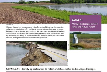
Under Goal 4, the plan recommends identifying opportunities to retain and store water and manage drainage, using methods such as two-state ditches, control devices near tile outlets, grass waterways and vegetated buffers.
Other recommendations under this goal focus on improved drainage water management to reduce downstream flooding and meet local water planning needs.
Goal 5: Resiliency in quality of life
Goal 5, takes a broad view of the recreational, cultural, spiritual and economic values that Minnesota’s water resources provide. It highlights how changes in precipitation, seasonal temperature patterns and water quality are affecting winter and summer recreational and subsistence activities, plant communities and animal populations. Infrastructure planning, design and development for recreational needs must adapt to these changing conditions.
Likewise, the plan calls for research and engagement to address the impacts of our changing climate and water resources on mental health and well-being, understand community values and beliefs around water, and identify strategies and resources to support psychological resiliency.
|
Like many museums, the We Are Water MN traveling exhibit was impacted by COVID-19, with the first two sites being postponed until 2021. However, demand and enthusiasm for the exhibit remain high and cities are willing to make accommodations to make the exhibit available.
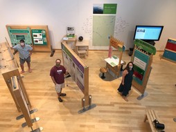
Exhibit Now at U of MN, Morris
The exhibit has reopened starting at the University of Minnesota Morris, where the Morrison Gallery had room for effective social distancing. Many events have moved online or are self-guided outdoors.
The online story collection remains popular and educator resources have been expanded.
|
Schedule for Revised Tour Across Minnesota:
- Now – Oct. 19, 2020 - University of Minnesota Morrison Gallery in Morris
- Oct. 22 – Dec. 21, 2020 - Blue Earth County Historical Society in Mankato
- March 7 – 8, 2021 - Hmong Museum in St. Paul (location TBD)
- March 11 – May 10, 2021 - Rochester Art Center
- May 13 – July 12, 2021- Minnesota Discovery Center in Chisholm
- July 15 – Sept. 13, 2021 - Meinders Community Library in Pipestone
We Are Water MN was created by the Minnesota Humanities Center in partnership with: Minnesota Pollution Control Agency, Minnesota Historical Society, and Minnesota departments of Natural Resources, Health, and Agriculture.
See We Are Water MN website for more information.
By Carmelita Nelson, DNR, Water Conservation Consultant
Beginning in October 2020, agricultural irrigators, golf courses, nurseries and other irrigators will start reporting the water efficiency measures they are implementing along with the annual amount of water they have used. This web-based “Water Conservation Reporting System” will complement the water use reporting system currently in place. Livestock operations with Minnesota DNR water use permits will begin reporting in January 2021.
Minnesota First to Measure Water Conservation
Minnesota is the first state in the nation to measure water conservation on a statewide basis. For the past three years, DNR has been working with cities, commercial, industrial and institutional water users to create a web-based system that allows them to report their water conservation and efficiency measures. We now want to partner with agricultural irrigators, golf courses, nurseries and livestock operators in this effort, to do the same for them.
The goal in gathering this data is to measure water conservation actions, track success and encourage efficiency. Ensuring sustainable use of waters, reducing losses and waste of water is everybody’s responsibility. The data will be aggregated, summarized and used in various legislative reports, conference presentations and other outreach with partners.
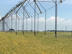
|
Photo above: Example of low-flow irrigation system.
All water appropriation permit holders will continue to report their monthly water use totals to the DNR through the existing Minnesota Permitting and Reporting System (MPARS) and pay the annual water use fee. Once this is completed, there is a link taking water users to the Water Conservation Reporting system.
For additional information please see DNR water conservation reporting system webpage.

The National Flood Insurance Program (NFIP) has had many short extensions since the last five year extension that expired Sept. 30, 2017. The latest extension is set to expire Sept. 30, 2020.
Currently, the House has proposed a one year extension to Sept. 30, 2021 as part of the proposed Federal budget continuing extension to Dec. 11, 2020.
Watch for the latest updates in the media and at the Association of State Floodplain Managers (ASFPM) site.
|
By Ceil Strauss, DNR, State Floodplain Manager
Editor's note: This is the first in a series on water infrastructure basics (see more below).
We value water, but many don't understand basics
- Half of American adults do not know where stormwater ends up.
- The American public is largely unaware that surface water runoff is the single largest source of water pollution.
These findings from a recent nationwide survey in Water + Us: How We Think, Feel, and Take Action on Water were shared by a co-worker recently.
I was not surprised by this finding. As the DNR Area Hydrologist covering the communities with Lake Minnetonka during the 1989-1990 low water period, I recall many related discussions. In particular, one resident was convinced that the reason Lake Minnetonka was about four feet lower than normal was because the city had put in new storm sewers and was sending all the water to the Pig's Eye waste water treatment plant in St. Paul! (In fact, storm sewers send more water to the lake, and sanitary sewage from that area goes in a separate system of pipes to a closer waste water treatment plant.)
|
What happens to rainwater and runoff?
As we all know, water runs downhill! The amount of rainwater runoff varies greatly depending on the land use in the area and the amount of impervious surface. Some will seep into the ground and some may get caught in depression areas, or rain gardens designed to infiltrate the water.
In urban areas with storm sewer systems, at least a portion of the water usually flows off roofs and driveways, and onto streets, when it rains. And during intense storms, or rain on still-frozen ground, water can't be absorbed fast enough and adds to the stormwater runoff. Water flows down the street to the nearest storm drain. Take a look on your street and you'll see those storm drains are placed at low spots along the road, and are intentionally spread out to manage each drain's capacity for runoff.
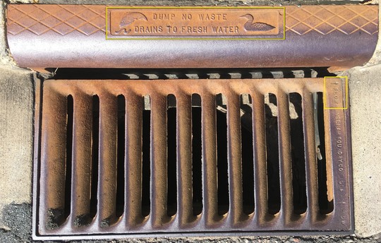 Photo: Example of a newer storm drain with "Dump No Waste - Drains To Fresh Water" signage, and arrow showing flow direction in upper right.
Adopt-A-Drain & Stenciling Efforts
Many areas have an Adopt-a-Drain program, encouraging residents to periodically check their local storm drains and clean them out, as needed, to prevent flooding due to blockage. See the Minnesota Adopt-a-Drain site. (For many parts of Minnesota: If you enter your address at this site, you can view an informative map showing the storm drain locations in your neighborhood.)
Youth groups, or neighborhood groups, may also work with communities to paint stencils or place signs that advise "No Dumping. Drains to River." or a similar message.
Newer storm drains (as in the above storm drain example) often have the "Do Not Dump" educational message.
 Photo: Close-up view of message on newer storm drain.
After runoff enters storm drain
Once rainwater runoff enters the storm drain, it goes into a "catch basin" that is below the storm drain grate that is seen on the street (like the example shown above). From the catch basin, water is directed to other parts of the storm sewer system.
Storm sewer pipes are connected to the catch basin at different angles and elevations, depending on the direction of flow. Connecting pipes will be different sizes, depending on the anticipated volumes of rainwater runoff.
Water flows from the catch basin into the underground storm sewer system.
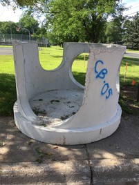
|
Photo above: Example "catch basin" (hence the "CB" painted on the structure) waiting to be installed. This structure will be placed below the storm drain grate that is at the street level. It will catch and direct runoff that enters the storm drain.
Underground storm sewer pipes
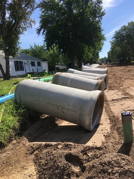
Water that has entered through storm drains might go a short distance, directly to a nearby lake or river, or through miles of storm sewer pipes below ground. Runoff can go through many catch basins, with the volume of water accumulating before it discharges from an outfall pipe into a waterbody.
In the photo to the right, sections of storm sewer pipe line the edge of a residential street in preparation for replacing the old system below the street.
As is the case in this example, when streets need replacement or major work, cities often replace old storm sewers, water supply pipes, and/ or sanitary sewers (i.e., wastewater) to avoid multiple projects disrupting neighborhoods and to keep overall costs down.
|
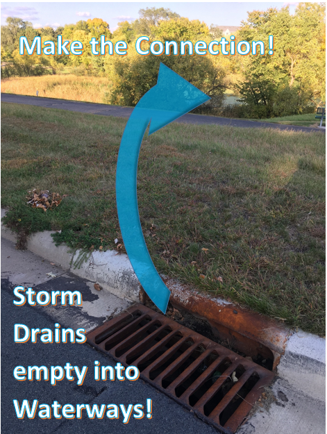
Storm Drains empty to Waterways!
No matter how short or long the route for the rainwater, it eventually enters one of our lakes, ponds or rivers.
Anything that is carried in the rainwater ends up in our waterways. This includes: pet waste, pesticides, fertilizer, leaves and other vegetative debris, sediment, road salt, spilled oils, and litter.
Hopefully, an educated public will think twice about sweeping debris and potential pollutants onto their street, since they will realize that all ends up in that local river or lake that they value.
|
Photo above: Storm drain that empties to a direct pipe to a pond.
Anticipated water infrastructure basics series:
- Where does rainwater go? Part 1: The main infrastructure. (This issue)
- Where does rainwater go? Part 2: Water quality improvement and flood control features.
- Where does our drinking water come from? Part 1: The main infrastructure.
- Where does our drinking water come from? Part 2: Water source and quality challenges.
- Where does sanitary sewage (wastewater) go?
Related topics can be added if there's interest. Send suggestions to Ceil Strauss.
By Dan Petrik, DNR, Shoreland and River Related Programs Coordinator
Confused about Permitting Mooring Facilities in Shoreland?
You are not alone! This is one of the most confusing aspects of shoreline use where standards and requirements of local ordinances and state public waters rules overlap.
The DNR recently released guidance for local governments to help them understand the applicable requirements and standards for mooring facilities, including the number of spaces, under both public water and shoreland management regulations.
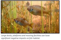
These standards and requirements exist to protect aquatic habitat and wildlife from the negative impacts of docks and motorized water craft. Docks and water craft shade out aquatic plants and eliminate habitat critical for fish spawning, feeding, and refuge from predators. Propellers in shallow areas also disturb sediment, which increases turbidity, releases phosphorous and destroys fish habitat. Local governments have the lead role in administering these standards and requirements and thus have the primary responsibility for protecting aquatic habitat and wildlife.
|
Regulatory Authority for Permitting
The first challenge in permitting mooring facilities is understanding that the regulatory authority for permitting depends on the land use generating the demand for mooring facilities.
|
If the demand is generated by:
|
Then:
|
|
Residential subdivisions, residential shoreland PUDs, or commercial shoreland PUDs (campgrounds, resorts or other lodging facilities)
|
The number of mooring spaces is regulated by the local shoreland ordinance; A DNR permit is generally not required.
|
|
Restaurants, bars, other non-lodging commercial uses, or other non-residential uses
|
The number of mooring spaces is regulated by local ordinances, unless mooring facility requires a DNR permit. These situations are relatively rare and are described in the guidance.
|
|
A marina
|
The number of mooring spaces is regulated through the DNR and local zoning permitting process; A DNR permit and local permit are required.
|
Mooring facilities
A mooring facility is a concentrated area intended solely for the mooring or containment of seven or more watercraft (or seaplanes) by docks, buoys, or other means. These facilities don’t need a DNR permit if they meet standards in the public waters rules. Project developers and local governments have responsibility to ensure compliance with these rules. In addition to protecting wildlife, compliance with the rules can also minimize neighbor conflicts or dock wars.
Marinas
Marinas are mooring facilities that also provide ancillary commercial services and they require a DNR permit AND local government approval.
Shoreland Ordinances
Regardless of whether a DNR permit is required, local governments must administer their shoreland ordinance provisions regulating number of mooring spaces for residential and commercial (e.g. resort, campground, hotel) PUDs.
|
If a DNR permit is required for a mooring facility that is also part of a shoreland PUD, the DNR will evaluate whether the proposed new and existing mooring spaces are consistent with the spaces allowed in the PUD provisions of the local government’ shoreland ordinance.
For more information
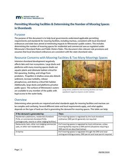
Please see the DNR’s guidance document “Permitting Mooring Facilities & Determining the Number of Mooring Spaces in Shorelands” for more information.
Image to right: DNR's Mooring guidance
|
|
 |
By Ceil Strauss, DNR, State Floodplain Manager
If you are considering constructing a new building or an addition, installing any type of structure, grading (filling and/or excavating) or doing any other work on your property, checking with your local zoning authority is the best place to start.
Who has what role? Local, State, Regional, and Federal Roles and Responsibilities

City or County (for areas outside city boundaries):
- Is the zoning authority.
- Issues permits based on regulations and standards in local ordinances.
- Coordinates with other levels of government with overlapping jurisdiction.
- Communicates final zoning decisions directly with the customer.
Others involved:
- State (e.g., DNR): Separate DNR permits if project is in a public water. DNR gives guidance to communities on meeting ordinance requirements based on state rules or federal regulations (i.e., FEMA floodplain regulations). Other state agencies may also have permit or approval requirements.
- Watershed Districts (or other watershed organizations): May have overlapping permit requirements. Often have technical data to help guide development.
|
What if city or county officials have questions on what should be allowed in a floodplain, shoreland or river-related district?
Local floodplain and shoreland management ordinances are based on state rules and statutes, and some of the requirements get complicated. Many local officials only deal with development in the floodplain or shoreland districts a few times a year, or less.
DNR Area Hydrologists cover specific portions of the state, and are a good resource for local officials. (See DNR Area Hydrologist map.) They may bring in program specialists to assist, depending on the questions. Community officials may also know their questions are specific to the floodplain or shoreland management programs, and contact DNR program staff directly.
Please don’t re-direct or forward the customer directly to the DNR. Instead, we are happy to discuss the situation with local officials so you can give direction to your customers.
A few reminders:
- If DNR staff are contacted about a project in your community, we will either direct the landowner (or others asking the questions) to the local officials or copy the community if DNR staff are providing data or information related to our programs for a specific location in your community.
- If a landowner (or others) contacts you about a project in a public water, floodplain or shoreland/river district, either loop in DNR staff, or - if the project is complicated or may be controversial - contact DNR staff to discuss guidance on direction.
- Sometimes, communities tell landowners (or potential developers, landowner representatives and others) to contact DNR staff directly on their own. We discourage this approach since: we want local officials to hear the guidance or data we shared for a site directly, the landowner often doesn't give all the needed background on the site or the local regulations involved, and some landowners are selective about what they pass on to the local official and give misleading "DNR said" information.
More details for projects in and near lakes, wetlands, and rivers
Projects on shorelines, or that may affect wetlands, lakes or rivers, can involve permits or approvals from multiple levels of government. But your city or county is still the best place to start.
-
Public Waters: Public waters and public water wetland are defined by state statute and identified in the Public Waters Inventory. Activities below the Ordinary High Water (OHW) level - the official boundary - are regulated by state law, and may require a DNR public water work permit. See Requirements for Projects Involving Public Water Work Permits.
-
National Wetlands Inventory (NWI) Wetlands: All other wetlands are regulated at the local level, usually by the city or county zoning office, or the county Soil & Water Conservation District (SWCD)
-
DNR's NWI Wetland Finder interactive map: See wetland locations and types, and which basins and streams are public waters. Location-specific links are also included for DNR Area Hydrologists (to answer questions about DNR public water regulations), and indicating which local government administers the Wetland Conservation Act (WCA).
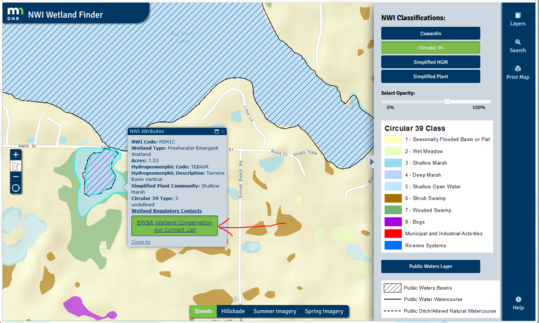 Figure: Example of information available at NWI Wetland Finder site.
Resources to locate watershed organizations:
Minnesota Association of Floodplain Managers Conference is Going Virtual!
This year’s MNAFPM virtual conference will be held over three half-days - Nov. 18-20, 2020.
Recognizing that a typical in-person event doesn’t always cater to those who aren’t in a floodplain-intensive role, this year’s webinar-style event will allow participants to come and go based on the sessions that interest them.
Registration for the 3-day conference is $50, and will open this week. Scholarships – particularly those for local officials – are widely available for those who may need one. Budgets for training opportunities may be tight this year, but registration costs are not a reason to miss out!
Please note that nominations are now open for the Floodplain Manager of the Year Award. Link here.
For more information, including conference brochure, registration form, and scholarship application, please visit the MNAFPM website at www.mnafpm.org.
|
By Kevin Zytkovicz and Salam Murtada, DNR - Division of Ecological and Water Resources
Minnesota, particularly its southern counties, have been experiencing frequent road washouts due to increasing rainfall intensity and flooding. Events occurring throughout March and April of 2019 caused several counties to be declared presidential disaster areas on June 12, 2019. This declaration provides financial assistance to repair and replace disaster-damaged infrastructure. Watonwan County was one of these eligible counties.
Katie Wigen, MNDNR Area Hydrologist for Watonwan River Watershed, coordinated efforts between the local townships, County DOT and DNR’s Division of Ecological and Water Resources (EWR) staff to assist road authority on infrastructure improvements for three damaged crossings over the Watonwan River: 730th Ave, 783rd Ave and 710th Ave. Recent approval and implementation of this approach for two crossings, located in Riverdale Township, are underway while the third site, located in Nelson Township, is under review. This article will focus on the two crossings (730th and 783rd) currently under implementation.
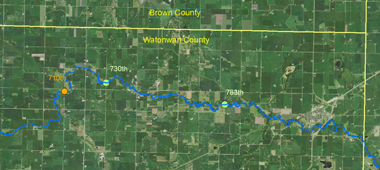 Figure: Locations of 710th Ave, 730th Ave and 783rd Ave culvert crossings in Watonwan County, MN
Improved watercourse infrastructure design should increase the resiliency and adapt the project to its stable landscape. Therefore, EWR staff applied the in-house developed Geomorphic Approach to Infrastructure Design at Road Watercourse Intersection, where stable river metrics are determined, then applied into the infrastructure design. This approach establishes channel and floodplain connectivity through the road while meeting Aquatic Organism Passage (AOP) criteria and local floodplain requirements (which include state and federal standards). During this study of the 783rd crossing, staff identified two floodplain culverts, which is good. But they were placed below the proper elevation, potentially resulting in sedimentation build up inside the structures. Often, floodplain culverts set too low cause sediment build-up inside the structure(s).
The computer modeling (iterative hydraulic modeling with HEC-RAS), required as part of the design approach, showed significant improvements to the river reach. By establishing a stable channel form through the roadway, and properly distributing the energies along the channel and across its related floodplain, shear stress and velocities stabilized, allowing flood overtopping to occur without damaging the road. Note, these road crossings are considered non-emergency routes, allowing for flood overtopping to occur.
Because the proposed mitigation was not considered "in-kind replacement," FEMA was not able to reimburse for the total cost of replacement prior to construction, making it difficult for the township to secure funding for these projects. As a result, they opted to construct the project in stages while seeking partial FEMA reimbursement post construction. We hope the process of funding these improved mitigation options will be further streamlined by FEMA.
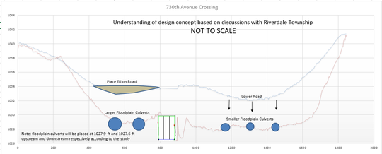 Figure: Proposed design for 730th Ave crossing (Source: DNR)
Project Discussion
For the 730th intersection (see above), the proposed design involved keeping the bridge in-place, placing fill north of the channel (raising the road top), and installing five floodplain culverts across its natural floodplain. Applying this design approach caused the Base Flood Elevation (BFE) to decrease by up to 0.5-foot upstream of the crossing. Downstream of the crossing, there was a minimal rise of 0.04-foot, caused by reduction in velocity; however, the rise is within the cumulative surcharge limit of 0.5-foot allowed for approximate study areas (A Zones). During the 10-year storm, the velocity decreased significantly - by more than 30% - and shear stress decreased by 50%.
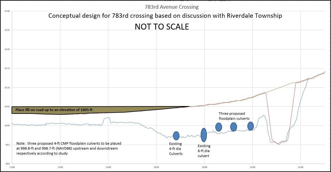 Figure: Proposed design for 783rd Ave crossing; (Source: DNR)
For the 783rd crossing (see above), the proposed design called for placing up to 2.5-foot of fill to the north of the channel, which is an area prone to frequent flooding, in addition to placing three floodplain culverts. The proposed condition caused a BFE increase of up to 0.30-feet due to a decrease in channel velocity. The BFE increase is within the 0.5-foot cumulative surcharge limit allowed for A Zones. During the 10-year storm, the velocity and shear stress decreased significantly, by up to 30% and 50% respectively.
At both sites, the proposed conditions maintained channel velocities of less than 3.0 feet per second during the 1.5-year event, meeting the Minnesota AOP guidelines.
When implemented, these projects will be included in our long-term monitoring plan to evaluate and further improve the design process and resiliency of watercourse infrastructure across Minnesota.
For more information
Visit Geomorphic Approach to Infrastructure Design at Road/River Intersections website to learn more about floodplain culverts, as well as floodplain and channel connectivity.
Actual, scheduled, and anticipated dates since July 2020 Water Talk:
Preliminary Maps
- Blue Earth County (panels) - Aug. 28, 2020
- Itasca County - October 2020 (anticipated)
- Anticipated Jan - March 2021: Carlton, Dodge, Le Sueur, Lincoln, Lyon (panels), Morrison, Pipestone, Rock and Winona Counties
Local Officials Meetings & Open Houses*
- Blue Earth County (revised prelim panels): Local Official Meeting - TBD 2020
- Chippewa County: Flood Risk Review Meeting for Local Officials - TBD 2020
- Koochiching County: Local Official Meeting - 10/22/2020; Open House - TBD 2020
- Olmsted County (panels): Local Official Meeting & Open House - TBD 2020
- Lake of the Woods County: Local Official Meeting - 10/23/2020; Open House - TBD 2020
- Lyon County (panels): Local Official Meeting - TBD 2020
- Murray County: Kick-off Meeting - Dec. 2020
- Pennington County: Open House - TBD 2020
- Pope County: Local Official Meeting - 8/20/2020; Open House - Nov. 2020
- Rice County (panels): Local Official Meeting - 7/16/2020
- Stevens County: Local Official Meeting - 8/31/2020; Open House - 10/19/2020
- Waseca County: Flood Risk Review Meeting for Local Officials - Dec. 2020
- Watonwan County: Local Official Meeting & Open House - TBD 2020
*All remaining 2020 meetings and open houses expected to be virtual.
90-Day Appeal Periods
- Cottonwood County - July 15 to Oct. 13, 2020
Letters of Final Determination (LFDs)
- Scott County - Aug. 12, 2020
- Red Lake County - Sept. 9, 2020
- Marshall County - Sept. 23, 2020
- Wright County - By end of 2020
- Yellow Medicine Counties - By end of 2020
Effective (6 months after LFD date)
None currently
Additional Map Update Information:
|