|
photo credit: MN DNR Beth Knudsen
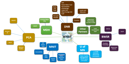
Watersheds Connect People and Places
Over the past 10 years, the Watershed Health Assessment Framework (WHAF) project has been expanding its reach to more people and more places.
Watersheds frame our stories by placing people together with their landscape. Watershed science builds our understanding of the ways we are all connected. Using those connections, we can find the best ways to live in our communities and to responsibly use our natural resources.
WHAF Shares Watershed Science
Minnesota has placed a strong emphasis on improving water quality and watershed health. As more data is collected, the challenge can be to deliver meaningful summaries for resource managers and community leaders.
The WHAF approach helps the user better understand the data. It is designed to:
- Provide a structured, science-based approach for understanding watersheds and watershed science.
- Help resource professionals and citizens work together with an accessible online platform.
- Grow our common understanding of Minnesota's complex natural resource systems by interpreting data with reports and summaries.
WHAF collaborates to serve a range of needs for agencies partners, educators, local governments and non-profits. Data access, training and outreach, advanced analysis collaborations; the WHAF staff responds to a range of requests as we seek to build a better understanding of watershed science.
The WHAF helps further the DNR Mission. While the WHAF focuses on delivering watershed science, the project also aligns and supports the broader mission of the Minnesota Department of Natural Resources.
- WHAF supports integrated resource management strategy to share stewardship responsibility with Minnesotans and partners to manage for multiple interests.
- WHAF makes data more accessible to our managers and constituents.
- WHAF interprets data as health scores, charts, reports and data summaries to build a shared understanding of Minnesota’s landscapes.
- WHAF delivers products that summarize historic climate data to support resource managers as they more directly address climate impacts and adaptation strategies in planning documents and management actions.
Growing our Community of Users
One way to track the impact of an online framework like the WHAF is to look at web 'traffic'. The number of visitors helps tell us if we are meeting an important and growing need.
Web Map Improvements
In an effort led by WHAF app developer Kitty Hurley, our map is state of the art. We are poised to better meet the needs of our users and we have a solid base for future advances. Her work created a new online platform that provides:
- Better user experience
- Faster, more stable
- Improved architecture
- Increased future capacity
- Innovation for other DNR mapping platforms
Working with our MNIT partners, the WHAF map was upgraded without any disruption in service. The use of the new map is already on the rise.

Newsletter subscriptions increasing
Another indicator of interest in the WHAF is the subscriber list for this newsletter. Initially kicked off with a few invitations, there are now 3300 subscribers that tune in for updates about the WHAF. This level of interest indicates a growing number of resource managers and other partners are finding the WHAF to be a solid and important tool.

Web page traffic
The WHAF web pages have been redesigned to improve the flow of information and enhance our website experience. This is reflected in our website traffic reports. The WHAF web pages see consistent year round use, averaging more than 30,000 page views per year.
Improved Information through Collaboration
We continue to enhance the information that is delivered by the WHAF and through the application. Through partnerships and collaborative development, our WHAF team has delivered several new products to our users this year.
For example, we have responded to requests to deliver new data layers in the WHAF Map while also making it easier to find the data you need. New data layers include:
- Groundwater and Drinking Water data layers (GRAPS) – MN Department of Health
- Fast Forest Disturbances (1974-2018) – MN DNR, Forestry
- Score the Shore – MN DNR, Fisheries
- Lake IBI for Fish – MN DNR, Fisheries
- Lake IBI for Plants - MN DNR, EWR
- Restorable Wetland Index, 2019 – Natural Resources Research Institute, U of MN
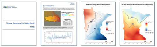
WHAF climate summaries bring insight, add value. Collaborating with DNR Climatology staff, WHAF data analyst Ben Gosack leveraged DNR's investment in statewide historic climate data to create several watershed-based summaries. This collaboration led to three climate data products; the Watershed Climate Summary reports, climate change data layers in the WHAF Map, and statewide animations of change in precipitation and temperature.
WHAF products improve efficiency. Collaborations have led to a range of shared data and analysis products that meet multiple needs and improve overall efficiency of staff from across agencies. The WHAF map and data summaries also provide a platform for discussion and further coordination. Here are some recent examples.
Support the Clean Water Fund:
- Stream Protection Priorities for WRAPS
-
Product: Analysis, annual updates, data delivery
-
Outcome: Access to accurate, current data for reports and planning
-
Partners served: MPCA, Local Government, DNR
- Drinking Water Grant Application
-
Product: Drinking water data for application delivered in WHAF map
-
Outcome: Easy public access to materials needed for timely application
-
Partners served: MDH and BWSR
Consult on Watershed Science:
- Stream Geomorphology Triage
-
Product: Target Tool added to WHAF map, training and use guide
-
Outcome: Consistent watershed review for prioritizing streams
-
Partners served: DNR-EWR Division
- Lakes of Phosphorus Sensitivity, Lakes of Biological Significance
-
Product: GIS data layers added to WHAF Map
-
Outcome: Additional lakes-related data and metrics (in development)
-
Partners served: DNR- EWR/DFW Divisions
Share the Science with Education and Outreach:
- WHAF Training for MPCA
-
Product: Full day in-person computer training session
-
Outcome: Enhanced use of WHAF for Stressor ID work
-
Partners served: MPCA-Brainerd Staff
- U of MN Water Quality Course
-
Product: Annual presentation/consultation for WHAF based curriculum
-
Outcome: Watershed science applied in the classroom using WHAF tools
-
Partners served: University staff, Grad/undergrad students
|


