|
The DNR has released a new shoreland
model ordinance to help counties and cities develop shoreland ordinances or update
existing ordinances consistent with Minnesota’s Shoreland Rules (6120.2500 -
6120.3900). While the shoreland rules have not changed since 1989, the new
model includes a number of improvements over the original 1989 model ordinance:
-
Consistency
with Statutes. Since 1989, statutes dealing with
variances, nonconformities and agricultural buffers have changed. The new model
includes language consistent with these statutory changes.
-
Consistency
with Rules. Over the same period, other state agency
rules dealing with feedlots, septic systems, wetlands and environmental review
have also changed. These changes have been integrated into the model’s performance
standards.
-
Plain
Language. The model has been rewritten and
reorganized with plain language. Long paragraphs of text have been shortened
and replaced with numbered lists, redundant language has been eliminated and
graphics have been introduced to illustrate key definitions and dimensional
standards.
-
Improved
Design & Provision Explanations. The model includes
two documents. The commentary document provides a line-by-line explanation of
many required provisions as well as optional provisions for better
administration and resource management. The second is an MS Word document that
only contains the model language for cutting and pasting.
Dan Petrik, DNR land use specialist, said
“the DNR will update the model ordinance periodically, based on user feedback and
to maintain consistency with related statutes and rules.”
The state shoreland rules and local
shoreland ordinances guide shoreland development to minimize impacts to habitat
and water quality.
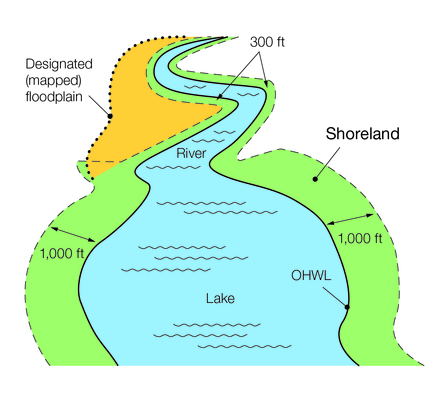 Shoreland is the area
within 1,000 feet of a lake edge and 300 feet from a river bank or the outer
edge of a floodplain, whichever is greater.
Figure 1: Shoreland District definition graphic
Adopting a shoreland ordinance is
recommended as a “Best Practice Action” to improve surface water quality under
the Minnesota
GreenStep Cities Program. Minnesota Statute 103F.221 requires
cities containing shoreland to submit ordinances to the DNR to review for
compliance with the shoreland rules. Minnesota Statue 414.033 also requires
cities to adopt a shoreland ordinance for annexed land containing shoreland.
|
The new shoreland model ordinance includes
a full array of zoning and subdivision regulations for most shoreland
management situations. The DNR will approve local shoreland ordinances that
contain all the provisions in the model ordinance. However, it is anticipated
that many ordinances will deviate from the model to address historical
development patterns and specific local water resources. Many model ordinance
provisions may duplicate language already in another ordinance section, while
some provisions may not be applicable, depending on how counties and cities
manage certain land uses.
The model ordinance documents can be
downloaded from the DNR
website.
Please contact your DNR
Area Hydrologist with questions about the model
ordinance or the process for getting DNR approval of a shoreland ordinance or
amendment.
 |
|
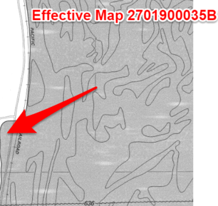
You are asked about a site that is clearly within the Special Flood Hazard Area (SFHA) in a Zone AE on the current effective Flood Insurance Rate Map (FIRM).
(See clip from the current effective FIRM in figure to the left.)
The base flood elevation (BFE) is between 636 and 637' NGVD on the current effective map.
The landowner wants to construct a new shed.
|
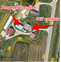
You look at the two-foot elevation contours at the proposed building site and see it is above the 640' NAVD88 contour.
(See example of two-foot contours overlaid on aerial to the right.)
|
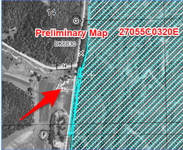
The county has a preliminary new FEMA countywide FIRM. The preliminary new map shows BFEs of 635.4' NAVD88 to the north (at cross section G) and 635' NAVD88 to the south (at cross section F).
On the new preliminary FIRM the site is shown in the lower risk Zone X.
Elevation information notes:
1.
The conversion between NGVD29 and NAVD88 is 0.0 feet in this area.
Normally it is important to convert elevations in one datum to be
consistent with the other datum. (In some parts of Minnesota there is a 1.4 foot difference!)
2.
Many communities have this elevation layer on their GIS systems. If
you are in Minnesota these elevations can also be seen on the MnTOPO
viewer. To learn more, see "Using MnDNR's MnTOPO Site" article at the
bottom of this Water Talk issue.
|
Questions from the local official:
- Can we issue a permit, or do we need to wait for new effective maps?
- Is the mandatory flood insurance still in effect?
- Can we use the base flood elevations (BFEs) on the new preliminary maps?
See answer at bottom of this newsletter.
Graphics source for this article: Houston County, MN
Guidance
Applicability
This
guidance applies to facilities generating solar power intended for off-site use.
These include solar gardens (consistent with Minn. Statutes 216B.1641), solar
farms, and utility scale facilities.
These are principal uses. Under Minn.
Statutes, §216E, facilities generating 50 MW or more require environmental
review and a permit from the Public Utilities Commission. Projects generating
between 25 MW and 50 MW require environmental review and typically need a conditional
use permit from the local government. Solar facilities generating between 5 MW
and 25 are subject to discretionary review (Minn. Rules 4410.4500). Because of their
smaller size (1- 5 MWs), solar gardens are reviewed and permitted by local
government.
This
guidance does not apply to facilities designed to provide power
primarily for the on-site primary use but where excess power may be sold back
to the grid. This type of on-site power generation is considered an accessory
use and should be regulated through a local zoning ordinance and permit.
See model
solar ordinance for ideas on how to regulate these facilities. These
facilities must also comply with applicable shoreland rule (Minn. Rules
6120.2500 – 6120.3900) provisions in local zoning ordinances – See Item #3
below.
|
Natural Resource
Considerations
Given the many positive benefits of using the sun’s energy
as a sustainable source of power, there are a number of natural resource
considerations in siting solar power facilities in shorelands and other sensitive
natural resource areas. Solar power facilities, or “photovoltaic generating
sites,” require a large footprint and in some circumstances can have
significant impacts to natural resources. In the big picture, it is not
sustainable to replace existing natural areas with power generating
facilities. Solar projects should be sited in the least
environmentally damaging locations where prior disturbance has already
occurred. In Minnesota, a majority of
the commercial solar sites have been located in agricultural fields, prior
mined sites, and in areas with low quality habitat. Developing solar sites in wetlands, native
prairie, or rare species habitat should be avoided. The shoreland rules were developed in 1989,
long before solar power became a feasible energy source, and thus do not
directly address this land use. The following guidance is provided for
communities exploring how to address solar facilities in shorelands.
Shoreland Rule Requirements
that are Applicable to Solar Power Facilities and Structures
1.
Prohibit on Natural Environment Lakes and Remote,
Transitional, and Agricultural River. The shoreland rules prohibit industrial uses in
the shoreland of lakes and rivers with these shoreland classifications (Minn.
Rules 6120.3200 Subparts 4 and 5). Solar
power generation fits within the shoreland rule definition of industrial use (Minn. Rules 6120.2500
Subp. 7b) – “the use of land or buildings
for the production, manufacture, warehousing, storage, or transfer of goods,
products, commodities, or other wholesales items.” Communities can either
apply this interpretation in administering their existing shoreland ordinances,
or, if they want more clarity, can amend their ordinances by adding a specific
prohibition of solar power facilities.
2. Allow as a Conditional Use on General
Development and Recreational Development Lakes, and Urban, Forested, and
Tributary Rivers. The shoreland rules only allow industrial uses as conditional
uses in the shoreland of lakes and rivers with these shoreland classifications
(Minn. Rules 6120.3200 Subparts 4 and 5). Before deciding to allow solar facilities as a
conditional use in these areas, communities should evaluate the impact of solar
power facilities in each shoreland on:
- Native
prairies and savannas
-
Lakes,
rivers, and wetlands
- State-listed
endangered or threatened species
- Other
high value natural resources important to the community
3.
Comply with applicable shoreland provisions (Minn. Rules 6120.2500 – 6120.3900) in local zoning ordinances, including:
- Structure
setbacks from the ordinary high water level and bluff lines
-
Impervious
surface limits
- Vegetation
cutting and screening requirements
- Height
limits
Other Considerations for Solar
Power Structures and Facilities in Shoreland
If a community decides to allow solar power facilities in shoreland
as a conditional use, it should take steps to protect shoreland resources when
reviewing and approving conditional use permits. While not addressed or
required in the shoreland rules, communities should consider amending their
ordinances to include specific conditions of permit approval. Following are conditions
of approval that communities should consider:
- The site must have been previously cleared of
natural vegetation to serve some other use and be in some other use for a
significant period of time – no intensive clearing allowed to site solar
facilities. A specific “waiting time” should be determined to avoid vegetation clearance
just prior to a solar generation application.
- Minimize placement of structures and facilities
on slopes over 12% in order to reduce potential erosion and runoff from the
site.
- Runoff rate and volume from the site is no
greater than if land were covered with 25% impervious surface for a two-year
event.
-
All structures and facilities must be screened
from view of public waters through siting design, specified limits on structure
height, use of ecologically appropriate vegetation for the site, or combination
thereof.
- Native vegetation should be planted on the site to
improve habitat conditions for birds, mammals, and pollinators. See the MnDNR
Prairie Establishment & Maintenance Technical Guidance for Solar Projects.
- Use of best management practices for managing
erosion control including the establishment of cover crops on prior farmed
sites. Cover crops have proven to
stabilize the soil, prevent widespread erosion and runoff, and improve construction
conditions at the sites.
-
Only approving sites that have avoided and
minimized impacts to valuable wildlife habitat, state-listed endangered or
threatened species and that do not have a significant impact to wildlife
movement on the landscape.
-
Potential impacts should be coordinated with the
appropriate agency to avoid, minimize, or mitigate for unavoidable
impacts.
|
Communities are encouraged to contact the DNR for help in assessing
impacts to these natural resources and in designing facilities that minimize
impacts on natural vegetation and wildlife. See the MNDNR
Guidance for Commercial Solar Projects.
Communities can be more restrictive than the statewide minimums and may
choose to prohibit solar power facilities in shoreland of all lakes and rivers
in their jurisdiction. It is ultimately up to each community to decide which
approach to take. Local governments should consult their attorneys/legal staff
on the best approach.
If a community elects to amend its shoreland ordinance to more clearly
address solar power facilities, all shoreland ordinance amendments must be
submitted to the MNDNR for review and approval to ensure substantial compliance
with state shoreland rules. Communities are encouraged to engage their area
hydrologist as early in the amendment process as possible.
Solar Projects in River-Related
Land Use Regulatory Programs
Solar facilities generating power for off-site use are not allowed in
the Lower St. Croix Riverway (Minn. Rule 6105.0370 Subp.2.) and the six Wild and Scenic
River districts (Minn. Rule 6105.0100 Subp. 3). Solar facilities located in
wild and scenic river districts within city boundaries existing at the time of
wild and scenic river designation are managed according to the shoreland rules
and should be consistent with the guidance described above for the Shoreland
Program.
Editor's Note: This is part 1 of 2. Part 2 will focus on solar power facilities in floodplain areas, and will be in the next issue of Water Talk
The following trainings by DNR staff are scheduled:
- July 12, 2017 (W), 1-4 pm - 4-H Building, Murray County Fairgrounds (Slayton); Floodplain Management Basics
- July 17, 2017 (M), 1-3 pm - Crow Wing County Land Services Building (Brainerd); FAQs to Expect When Getting New DFIRMs, and available Resources
- August 2, 2017 (W), 1-4 pm - Wheaton American Legion; Floodplain Management Basics
- October 5, 2017 (Th), 8:45 am - 4 pm - Thief River Falls; County Selected Special Topics
- November 2, 2017 (Th),
8:45 am - 4 pm - Blue Earth County Historic Courthouse (Mankato); Special Topics (topics to be chosen by those attending)
Other trainings are in the process of being scheduled in Fall 2017. MnDNR will be updating the Floodplain
Training and Education page as we get upcoming trainings confirmed.
Contact Ceil Strauss at ceil.strauss@state.mn.us or 651-259-5713 for more details on the topics to be covered at a particular site, or to RSVP for a training.
(aka "Section 28 Letters")
Have you - as a local official - received any calls from landowners in your community asking for a copy of their elevation certificate? Have you wondered what precipitated that call? The FEMA "Clear Communication of Risk" Letters could be one explanation.
Why Letters are Being Sent to Flood Insurance Policy Holders
FEMA’s “Cost of Flood:
Policyholders” page gives a good summary explanation:
"You have received this letter because Section 28, Clear Communication of Risk, within the Homeowner Flood Insurance Affordability Act of 2014*
(HFIAA) requires FEMA to clearly communicate true flood risk to
individual property owners. To meet this requirement, FEMA is writing to
all National Flood Insurance Program (NFIP) policyholders to explain
their current policy rating and discuss how and when Elevation
Certificates can be useful."
Congress was concerned that many policy holders - especially those with older buildings or that have been "newly mapped" - are not aware:
- Their current policy premiums are subsidized (i.e., those structures built before there was a FEMA Flood
Insurance Rate Map (FIRM) that use pre-FIRM rates, and those that use the "newly mapped" rates);
- They are likely to be at a higher risk of flooding than they realize (especially the pre-FIRM & "newly mapped" structures);
- The pre-FIRM premiums are increasing by up to 18% a year for primary residential properties and 25% a year for non-residential and non-primary residential structures; and
- Elevation data may show the structure is not far below (or possibly above) the BFE, and that they would have less expensive premiums if they are rated using the actual elevations.
What Do the Letters Say?
 There are different letters for each of the main groupings of policy holders:
Letter A - Buildings Newly Mapped Into a High-Risk Flood Area
Letter B - Buildings Standard-Rated, and Outside of the High-Risk Flood Area
Letter C - Buildings Grandfather Rated, And In A High-Risk Flood Area
Letter D - Primary Residential Pre-FIRM Buildings In A High-Risk Area, Paying A Discounted Rate
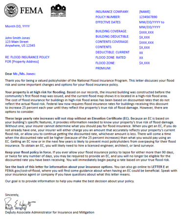
Figure 2: Sample FEMA "Clear Communication of Risk" Letter E
|
 Letter E - Certain Pre-FIRM Buildings In A High-Risk Area, Paying A Discounted Rate
*Letter F - Buildings Mapped Outside Of A High-Risk Flood Area, And Insured With A Preferred Risk Policy (PRP)
*Letter G - Buildings That Are Post-FIRM, In A High-Risk Flood Area, And Paying A Rate Based On True Flood Risk
* Letters not available on FEMA site as of 6/29/2017.
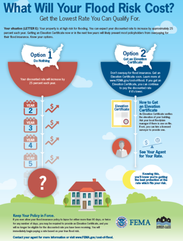
The "What Will Your Flood Risk Cost?" page (copy to right) is attached to Letters A, C, D and E.
|
What Does This Mean For Local Officials?
-
Be aware these letters are being sent to
the policy holders in your community, and that it is currently expected
those letters will be sent annually.
-
Ask what letter version they received if
you get a call that seems to be in response to a Clear Communication of
Risk letter. Then you will know what FEMA believes
is their category of risk. (Near the bottom of the letter it says,
"Additional information is available online for LETTER X . . .).
-
Provide existing elevation data if your community has a FEMA elevation certificate or similar elevation survey data on file.
-
Check other elevation data sources. If
you don't have elevation data for that site, provide available
elevation data to help them determine how low (or high) their lowest
floor is compared to the Base Flood Elevation (BFE). For example, check
LiDAR elevations (or the 2-foot contours derived from the LiDAR) in
your community GIS or public interactive maps, or on the public MnTOPO
site. (Note: To learn more, see "Using MnDNR's MnTOPO Site" article at the bottom of this Water Talk issue.)
-
Direct to FEMA's Letter of Map Amendment (LOMA) process, if applicable. If some cases you will see that the house is actually above the BFE, or that the structure is not actually in the higher risk zone, and they are eligible to apply for a LOMA. See more about the LOMA process at the MnDNR Map
Appeals and Amendments site.
-
Direct to information on whether an elevation certificate may help them get better insurance rates either now or in the future:
- Encourage landowners to consult with their agent on whether an elevation certificate may help them get a better rate.
- For those receiving a Letter E (for structures built before
the first Flood Insurance Rate Maps that have "pre-FIRM" rates), note that their agent can calculate the premiums two ways and use the cheaper of the two: (1) the pre-FIRM rate or (2) rates based on actual elevations. The higher the lowest floor (including basements & crawl spaces) is
relative to the BFE, the lower the flood insurance premium will be. If the
lowest floor is within a few feet of the BFE, they are more likely to
have a lower premium based on the actual elevation rates versus their
current "pre-FIRM" rates. Note that the "pre-FIRM rates are increasing up to 18% a year for
primary residential and up to 25% a year for non-residential and
non-primary residential (i.e., 2nd homes, or rentals), and there is not a cap on those increases, so it is likely that the elevation
based rates will be better at some point in the future even if they are
not better now.
- Direct them to more information on the relative cost of flood
insurance premiums at FEMA's www.floodsmart.gov site or on the MnDNR Flood
Insurance site.
- Caveat: Sometimes it is discovered the policy was not
correctly rated and they should have been paying a higher premium.
-
Consider whether to hire a surveyor & get an elevation certificate: Advise landowner to carefully read the letter from FEMA (including the attachments & links), consider input from their agent on whether an elevation certificate could be useful and the available elevation information & BFE for the site, and then determine if it makes sense to pay for an elevation certificate.
Actual, scheduled and projected dates since December 2016 Water Talk:
Preliminary Maps
- Polk County (revised) - August 2017 (anticipated)
- Scott County (revised panels) - August 2017 (anticipated)
- Wright County (revised) - September 2017 (anticipated)
- Fillmore County (revised) - Q3 2017 (anticipated)
- Blue Earth County (revised panels) - Q4 2017 (anticipated)
90-day Appeal Period
- Carver County - December 29, 2016 to March 29, 2017
- Fillmore County - February 27 to May 27, 2017
Letter of Final Determination (LFD)
- Crow Wing County - February 15, 2017
- Kittson County - March 29, 2017
- Marshall County - by end of 2017 (anticipated)
- Scott County - by end of 2017 (anticipated)
- Wright County - Q1 2018 (anticipated)
- Polk County - Q1 2018 (anticipated)
Effective (6 months after LFD date)
- Crow Wing County - August 15, 2017
- Kittson County - September 29, 2017
See the Zoning Challenge article earlier in this newsletter for background on the questions.
Q1. Can we issue a permit, or do we need to wait for new effective maps?
There are two main considerations:
Can a permit be issued? - Yes, the local zoning authority can issue a permit at any time. They do not need to wait for preliminary new maps to become effective. (But consider the points in question 3 below).
What if there are discrepancies in where the floodplain boundary is located when looking at the actual ground elevations versus the mapped Special Flood Hazard Area (SFHA)? - In Minnesota, the community's floodplain management ordinance should have a paragraph (typically titled "Interpretation") that is consistent with Minnesota Rules 6120.5700,
subp.3, D: “Where a conflict exists between the floodplain limits illustrated
on the official zoning map and actual field conditions, the flood elevations
shall be the governing factor in locating the regulatory floodplain limits.”
So what does that mean? There are two possible scenarios, as highlighted in figure 3 below:
A. The actual ground is higher than the base flood elevation (BFE) - Site A below
- If the site is within the Special Flood Risk Area on the current
effective FEMA map, federal regulations (44 CFR 60.3 (c) (3)) specify the lowest floor must meet minimum elevations. In
Minnesota, the minimum elevation is the Regulatory Flood Protection
Elevation (RFPE), which is the BFE + 1 foot of freeboard + any stage
increase due to establishing the floodway (or any higher local
standard).
- Note that if the site is really high (e.g., Site A in figure 3 which shows a site about 20 feet above the BFE), it is possible to have a basement and still meet the minimum elevation requirement.
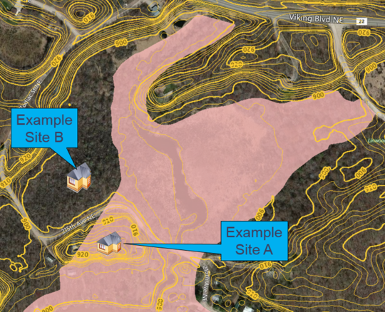 Figure 3: Comparing actual ground elevations to the Zone A on the Flood Insurance Rate Map (FIRM). Pinkish area is the Zone A. Graphic source: modified MnDNR MnTOPO viewer clip
B. The actual ground outside of the SFHA is LOWER than the base flood elevation
(BFE) - Example Site B above.
Since the ground at Site B is lower than the BFE, the community's floodplain ordinance applies and a permit is required to ensure that any new structure meets the ordinance standards.
Q2. Is the mandatory flood insurance still in effect?
For current effective Map - YES, since the site IS within the SFHA on the current effective map, and lenders MUST use the current effective map, the lender is obligated to require flood insurance unless a Letter of Map Amendment (or other official map revision) is obtained from FEMA.
When new map is effective - Once the preliminary new maps become effective the lender would be require to use that new effective map and flood insurance would not be mandatory. (Since the site is near a high flood risk area they should be encouraged to obtain a discounted Preferred Risk Policy.)
Option to obtain a LOMA - However, the better elevation data could be used to apply for a LOMA. In fact, for a site in Minnesota the two-foot elevation contours show the site is high enough to apply for a LOMA based on LiDAR. See more about applying for a LOMA at MnDNR’s Map
Appeals and Amendments page or about a LOMA with LiDAR at MnDNR’s Letter
of Map Amendments Using LiDAR Elevation Data page
Q3. Can we use the base flood elevations (BFEs) on the new preliminary maps?
When the current effective map has detailed study (i.e., Zone AE) - as in the Zoning Challenge example - the current effective map BFEs continue to be official until the new map's effective date.
If BFEs are going DOWN the higher BFEs on the current effect map MUST continue to be used for permitting and insurance determinations until the new map is effective.
If BFEs are going UP the community is encouraged to adopt that preliminary map and say in their ordinance that they will look at both the current effective map AND the preliminary new map, and use whichever is more restrictive. If the community does not adopt the preliminary new maps, they should strongly encourage construction based on the anticipated higher BFE so the structure doesn't become a non-conformity.
Related previous Water Talk articles:
Zoning Challenge - Can I Use the New Maps that are Not Effective Yet?
A
Zone Models: When Can They be used for Best Available Data BFEs?
|