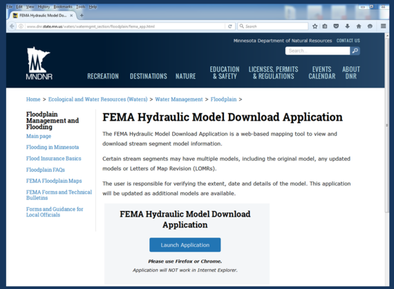
Tired of looking high and low for FEMA Hydraulic models?
Look no further! The MNDNR’s FEMA Hydraulic Model Download Application is a
web-based mapping tool that allows users to view and download stream segment
model information. Certain stream segments may have multiple models, including
the original model, any updated models or Letters of Map Revision (LOMRs). Most of the Basic Engineering Models are in the
system along with many of the detailed study models and some of the LOMR
models. We anticipate all of the models DNR has will be in the system before
the end of the year. For
more information click
here.
Figure 1 - The new MNDNR FEMA Hydraulic Model Download Application home page
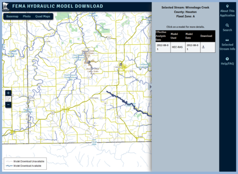
The following categories of hydraulic models can be downloaded:
Detailed studies in Flood Insurance Studies (FIS)
Studies that have been updated for a Letter of Map Revision (LOMR)
Basic Engineering models (aka "A Zone models")
There is an interactive map that shows the stream reaches where the state has a hydraulic model.
See example in Figure 2 (below).
CAVEAT: MNDNR cannot guarantee that the models are the most recent.
Sometimes MnDNR does not receive the updated models that are done for
Letters of Map Changes (LOMRs) or as the supporting data for a "No Rise"
certification.
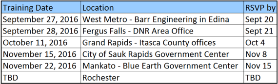
Time: Registration at 8:30. Sessions run from
8:45 am to 4 pm with an hour break for lunch. Two tracks will be offered for
most of the day so those attending can choose to cover basics or more advanced
topics.
Cost: FREE for training. At most
locations there will be an opportunity to order (and pay for) box lunches that
morning; bring cash or a bag lunch.
Target Audience: City, county and watershed
staff who administer shoreland ordinances, floodplain ordinances,
interpret FEMA flood maps, or determine flood elevations; or consultants,
surveyors, insurance agents, realtors, or others who work with these issues.
Feel free to forward to others who do work in mapped floodplain areas.
If you are interested in this training, please RSVP by the
date listed for the location you will be attending.Contact Matt Bauman at matthew.bauman@state.mn.us
or 651-259-5710. Late registrations or walk-ins are welcome, but
knowing the number of participants by the RSVP date will help us prepare.
Topics Covered:
History of floodplain management regulations, roles, definitions, & permitted uses in floodway vs flood fringe
Save the date for the 2016 Minnesota Association of
Floodplain Manager’s conference. The 2016 MNAFPM conference will be held on
November 16-18 at the Best Western Kelly Inn in St. Cloud, MN. The MnAFPM
annual conference attendees consist of federal, state and local government
officials, planners, engineers, consultants, researchers, educators, watershed
organizations, realtors, appraisers, and insurance agents. The conference
agenda will focus on hydrologic and hydraulic modeling, recovery programs,
flood control projects, stream restorations, case studies and mapping.
The conference will include the Certified Floodplain Manager
(CFM) review and exam as well as training sessions and a field tour. The
conference will also include vendor exhibits and networking opportunities.
Please consider submitting an abstract for the
conference. Anyone wishing to make a presentation must submit an abstract
describing the material to be presented. Submit your abstract here. Abstracts are due by July 8, 2016.
You are the local floodplain manager. A resident contacts
you and says they are applying to FEMA for a Letter of Map Revision based on
Fill (LOMR-F).They brought fill around
their foundation and have a survey that shows the lowest adjacent grade (LAG) –
or the lowest ground touching the building – is above the base flood elevation
(BFE).To complete their LOMR-F
application, they need to have someone from the city sign the “Community
Acknowledgement Form.”
You check your records and see that house has a basement.
You ask if they filled in the basement, and they say “no.”
What do you tell them?
See bottom of this Water Talk newsletter for answer.
Map Modernization, or MapMod, was the federally funded
program that initiated the conversion of the country’s Flood Insurance Rate
Maps (FIRMs) from paper to digital maps.FEMA’s Risk Mapping, Assessment and Planning (Risk MAP) program has superseded
and expanded on the old MapMod program.There
are a number of improvements as part of Risk MAP including: more participation
with communities and local officials throughout the process, decision points
throughout the process that help define the path forward, watershed based
studies instead of county based studies, and a focus on different levels of
risk instead of simply being in or out of the floodplain.
This article will discuss the new Risk MAP products and how
they show different levels of risk, instead of being focused on only being in or out of the floodplain.Many
of these products are considered “non-regulatory” products; meaning they are
not developed for use with the National Flood Insurance Policy (NFIP)
regulations, but have other uses such as better defining risk or helping a
community prioritize mitigation actions.Since the risk associated with flooding can vary drastically from
community to community, products are selected and designed based on what an
individual community needs.
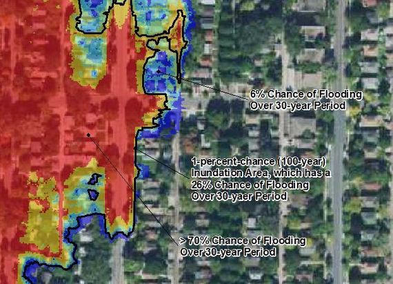
Figure 3 - Example of a Risk MAP product that shows the risk over a 30-year period.
Examples of some of these products include:
Changes Since Last FIRM – The Changes Since Last
FIRM (CSLF) Map show how the Flood Insurance Rate Map (FIRM) will change once
new maps are issued for a county or watershed.This map is used to help communities easily identify locations where
there has been an increase or a decrease in the Special Flood Hazard Area
(SFHA, or 100-year inundation area) or where there has been a change in the regulatory
floodway. Community officials can help
homeowners who will now be placed in the floodplain find the best insurance
rates, or alternatively, help those who have been paying insurance get refunds
if they will be removed from the floodplain.
Areas of Mitigation Interest Maps – These maps
highlight areas where there have been repetitive flood damages or where there
have been severe flood losses.They can
be used to help prioritize flood mitigation efforts and dollars.
Depth Grid Maps – Depth grid maps show the depth
of flooding during 10-, 0.2-, 0.1-, or 0.02-percent-chance flood in addition to
flood extents.These maps can help
communities determine where there will be substantial damage because and where
buy-outs may be warranted, or where flooding may be shallow and floodproofing
homes or structures may be more appropriate.
Percent Chance of Flooding and 30-year Percent
Chance of Flooding Maps – these maps are intended for education.Instead of only indicating that a home is in
or out of the 1-percent-chance floodplain, these maps show the percent chance
of flooding in any given year, or the percent chance of flooding over a typical
30-year mortgage.One additional benefit
of these maps is that they don’t stop at the 1-percent-chance floodplain
boundary.They show that even outside of
a Special Flood Hazard Area, there can still be a risk of flooding. See the example in Figure 3 (above).
Flood Risk Report – This report summarizes the
above maps with additional information that can be beneficial to a
community.The report focuses on watershed
specific flooding issues and lists tools that can be used by communities to
help them mitigate their flood risk.The
report is developed with input from the communities so the document can become
a working resource.
The regulatory products, such as the Flood Insurance Study
and the FIRM’s will always be part of the dataset that is updated by FEMA.But with the Risk MAP program, local
communities now have the flexibility to develop and use the products that will
be the most helpful for them.In
addition, if a community has ideas for other products that will help somehow reduce
flood risk – through education, planning, or mitigation, they will have FEMA’s
support.
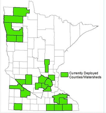
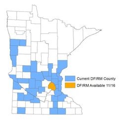
For areas that are currently deployed (see map), FEMA has
immediate funding available to develop the non-regulatory products if they will
be useful for a community.For more
information on these products, contact the state’s Floodplain Action
Hydrologist, Rita Weaver at 651-259-5802 (rita.weaver@state.mn.us).
Many of you have made "FIRMettes" at FEMAs Map Service Center site since
they became available in 2002. FIRMettes have been very handy. They are so much nicer than trying to photocopy an area on the large Z-fold
Flood Insurance Rate Map (FIRM) panels. The FIRMette makes it possible
to print a nice letter sized or 11' x 17' map of just the area of
interest with the scale, north arrow, and panel information. The tool
forces the scale to be the same as the official panel, and it has a note
saying it's an official copy of that portion of the FIRM.
But now many of the counties in Minnesota (and the country) are Digital Flood Insurance Rate Maps (DFIRMs). In DFIRM counties the floodplain layers can easily be seen on FEMA's more recent National Flood Hazard Layer (NFHL) viewer with a nice aerial photo background, or other background options.
Until recently, we could not take advantage of those much clearer NFHL layers and aerial photos when printing a FIRMette for official purposes. Now we can!
In addition to a clearer map with an aerial background, the new FIRMette option has two additional advantages:
Any Letters of Map Revisions (LOMRs) are incorporated in the NFHL FIRMette, which is not possible when doing a FIRMette using the panels at FEMA's Map Service Center. This is an important benefit!
A location pin can be placed by the person preparing a NFHL FIRMette.
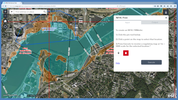
There are two ways to get to the new FEMA NFHL printing tool
and do a FIRMette:
(2)If you use the print feature in the NFHL
viewer, the wording at the top of the printout will have a link to the NFHL
Print Tool site.
Figure 6 - Home page for the National Flood Hazard Layer Pint Tool
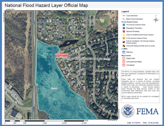
At the NFHL print tool site, enter the address of interest. Then follow steps 1, 2 and 3. Depending on your computer, the tool may "think" for a while, but will then download a FIRMette similar to that in figure 7. Print or save your new "Official" FIRMette that has a little orange "pin" on the structure you noted.
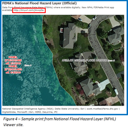
Figure 5 - Sample National Flood Hazard Layer FIRMette. Note this is printed at regulatory map scale of one inch = 500 feet.
In some Minnesota DFIRM counties, the official aerial background is an early 1990s era aerial photo, so that is what is used in the NFHL FIRMette (the same as the default on the NFHL viewer site for those counties).
If it's difficult to verify whether the structure is in the Special Flood Hazard Area (i.e., the A Zone or 100-year floodplain) with the one inch = 500 foot scale, it may be helpful to include a zoomed in print from the NFHL viewer site as supporting information. See a sample zoomed in NFHL viewer print in figure 4 (above).
For more information about FEMA's NFHL viewer and Map Service Center sites, see these previous Water Talk
articles:
There are times when an area is accurately mapped “in” the
special flood hazard area (the one percent annual chance floodplain, aka the “100-year
floodplain”). The area is low at the time the mapping is done. However, if the
landowner constructs a building in accordance with the community’s floodplain
regulations, it is possible to apply to FEMA for a Letter of Map Revisions
based on Fill (LOMR-F), and get a document that says the building is officially
moved “out” of the floodplain and are not subject to the mandatory flood insurance
requirements.
There are many opinions on whether LOMR-F should be allowed,
but that is a separate topic (and maybe a future Water Talk article). LOMR-Fs
are currently a legal option.
In order to receive a LOMR-F, the applicant submits
supporting data. In the federal regulations section titled “Revision to special
hazard area boundaries with no change to base flood elevation determinations”
(44 CFR 65.5) there is specific guidance on what data must be submitted.
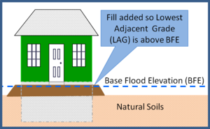
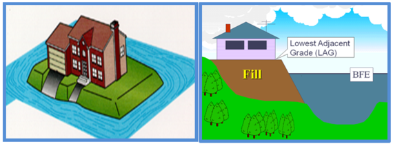
Figures 3a & 3b – Letter of Map Revision based on Fill (LOMR-F) examples. The site was low, but fill was placed so the lowest adjacent grade (LAG) is at or above the base flood elevation (BFE).
A closer look at the requirements for a LOMR-F
The details are in 44 CFR 65.5, but there are two key data
requirements:
(1)“A topographic map or other information . . .”
(typically a survey) that confirms the lowest adjacent grade - the lowest place
the ground touches the building – is at or above the base flood elevation
(BFE).
(2)“Written assurance by the participating
community that they have complied with the appropriate minimum floodplain
management requirements under Section 60.3.” This section goes on to say the
community is assuring that: the low floor of any existing building is above the
BFE, any existing or future building will be “reasonably safe from flooding,”
and all necessary permits.
How LOMR-F requirements have changed
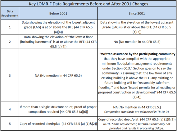
Congressional concerns led to subtle, but significant changes in the LOMR-F submittal requirements listed in 44 CFR 65.5
in 2001. The key changes are summarized in the following table.
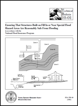
Since “reasonably safe from flooding” is not defined in the
code of federal regulations, the community must reference FEMA Technical
Bulletin 10-01 “Ensuring
that Structures Built on Fill In or Near Special Flood Hazard Areas are
Reasonably Safe From Flooding (2001).In this technical bulletin it explains that IF a full or partial lot
LOMR-F is obtained first, specific construction standards may be used for a
basement that meets the “reasonably safe from flooding” requirement.
NOTE: In Minnesota, the basement construction standards in TB 10-01
cannot be used unless a community has adopted this FEMA bulletin in their
floodplain management ordinance. Only a few communities have done so.
Does a LOMR-F take the property out of the floodplain?
For flood insurance requirements:
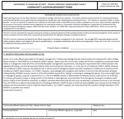
Yes. As noted above, the LOMR-F
removes the mandatory flood insurance requirement. In FEMA’s eyes, the building
is not in the special flood hazard area anymore. However, when the community
signed the Community Acknowledgement Form they vouched that any existing or proposed structures meet the floodplain regulations.
For zoning:
Depending on state and local regulations, the
structure may still be subject to the floodplain management regulations or other local regulations.
In
Minnesota, there are several other steps required by state law before the
property is removed from the floodplain for zoning. Minnesota Rules (6120.5800, subp. 2) require
the area be filled above the Regulatory Flood Protection Elevation (RFPE), and
contiguous to other lands lying outside the floodplain (or that flood control
measures meeting Minnesota Rules 6120.5900 are constructed and operating).In addition, the community must adopt the LOMR-F by officially amending their
floodplain management ordinance.
Also, if the site is within a shoreland district, the community's Shoreland Management regulations would still require minimum elevations.
Webinar
participation is free, but registration is required.
NO SHOW
Policy: If you
cannot make the training, you must cancel 24 hours before the class is
scheduled. Failure to attend two or more classes without notice will affect
your eligibility to register for future classes.
CRS: Intro to CRS, July 12 @ 12 pm (central)
CRS: The Role of the Community CRS Coordinator, July 13 @ 12 pm (central)
Letters of Map Change, July 14 @ 12 pm (central)
Tools for Determining BFE, July 28 @ 12 pm (central)
CRS: Preparing and Annual Recertification, August 16 @ 12 pm (central)
I need proof that our local floodplain
regulations are met before I can sign the form.
For new and substantially improved structures our ordinance requires
the lowest floor - including the basement - to be above the Regulatory Flood Protection Elevation (RFPE). The RFPE is at least one foot higher than the BFE.
For existing structures, federal regulations (44 CRF 65.5 (4) (i)) require that our community assure the lowest floor (which includes basements) is above the BFE.
NOTE: Learn more about LOMR-Fs in this newsletter's article on "LOMR-Fs - Some Basics and Historical Context"
Keep in mind . . .
Let's say someone applies for a LOMR-F, shows the lowest adjacent grade is above the BFE, but does not provide the lowest floor elevation. The FEMA reviewer cannot ask for the lowest floor (since it is not one of the data requirements listed in the federal regulations (44 CFR 65.5 (a)).
However, if the application has the low floor elevation, and it is below the BFE, the case will be flagged for FEMA headquarters to review as a potential violation.
Or if there is any other reason to believe there is a violation, the community can be asked for supporting information. The Community Acknowledgement Form the community official signs includes the statement "we have available upon request by DHS-FEMA, all analyses and documentation used to make this determination."