|
January 27, 2022
Special Redistricting Edition
 |
|
Overview |
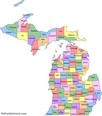
The Bureau of Elections is currently working to update the QVF with new district assignments based on post-2020 census redistricting. Compared to prior redistricting cycles, BOE has modernized the redistricting approach in order to make QVF updates as efficient as possible for BOE and clerks. Updates to QVF are proceeding in 3 phases. During the first phase, BOE is automatically updating County Commissioner, State House, State Senate and US Congressional district assignments for jurisdictions that are within a single district. This phase should be completed within the next two weeks. In the second phase, BOE will geocode QVF addresses and pre-assign updated district values to street segments based on their location. In Phase 3, local clerks will both review the pre-assigned district values and communicate precinct boundary changes to BOE. Geocoding addresses to pre-assign them significantly speeds up the process but because it does not always result in the address being in the correct district location, the third phase is critical to ensure addresses are in the right districts.
Clerks may submit precinct boundary changes either by submitting a “marked up” street index listing report (the system used after the 2010 redistricting), or can use the newly developed electronic redistricting module in QVF. Instructions on how to use this new module will be available soon. If anyone would prefer to start the process of determining new precinct boundaries before their redistricting is complete in QVF, a custom voter list can be exported from QVF to help with this process. See the related article, Custom Voter List for Precinct Totals.
The Bureau will continue to communicate updates via these weekly special redistricting News Updates to keep you apprised of the progress. Stay tuned for next week’s newsletter for details about new voter information (ID) cards.
Custom Voter List for Precinct Totals |
|
 |
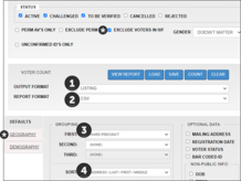
A Custom Voter List can be used to estimate voter population totals for new precincts. To generate the report from QVF, follow the steps below. Once the report is generated, you may apply filters, then sort columns based on street name and/or house number. Using the report in this way requires you to visually check the location of streets within your new precincts on a separate map, then tally up the voter records on the custom voter list for that area. Although it can be time-consuming, this method does give you an idea of voter population for new precincts. Inactive/IVF voters may be excluded from the calculation of precinct size. They are still considered eligible voters, but are not counted toward the maximum allowable precinct population. For the purpose of planning resources for running a precinct, you can choose to leave them off this report. Refer to the optional criteria shown below.
Reports>Custom Voter List, Report Options:
Sort: Address/Last/First/Middle
*Optional Report Criteria
-
Select specific precincts for export using the Geography & Precincts tabs
-
Exclude the voters on the inactive file by checking the “Exclude Voters in IVF” box
|