|
Oct. 14, 2026
Contact: Kerry Heckman, 517-643-1256 or Beth Fults, 517-282-5985
Containment efforts continue on Ridge and Craig Lake fires
DNR also has taken over management of Black River Fire from U.S. Forest Service
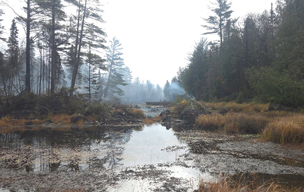 Fire crews from the Michigan Department of Natural Resources continued battling the rugged terrain and difficult access of the Ridge Fire and Craig Lake Fire Wednesday, making containment progress on both.
The Ridge Fire is now estimated to be 434 acres and 30% contained. The cooperation of area landowners continues to provide critical information to assist firefighters in gaining necessary access and knowledge of the landscape. The Ridge Fire is located 10 miles northwest of Marquette and north of the Dead River Basin west of County Road 510. The Ridge Fire was spotted by a DNR pilot Oct. 9; the cause of that fire remains under investigation.
The Craig Lake Fire, located north of Craig Lake State Park, is now estimated at 604 acres and is 50% contained. The DNR confirmed the cause of the Craig Lake Fire as being a lightning strike. There were multiple storms that produced lightning across the Upper Peninsula between Oct. 5-8. It is not unusual for a lightning strike to smolder for a few days before weather conditions, such as high winds, cause it to spread into dry fuels resulting in wildfire. The Craig Lake Fire was detected by a DNR pilot Oct. 8.
On Wednesday, the DNR had 41 firefighters on the ground on the Ridge Fire and 24 firefighters on the ground on the Craig Lake Fire. A 21-person DNR Incident Management Team is managing both fires. Additional support is provided by the U.S. Forest Service, Michigan State Police, Marquette County Sheriff’s Office and Emergency Management, Baraga County Emergency Management, Michigamme-Spurr Fire Department and DNR Law Enforcement Division.
‘Ready, Set, Go!’
The status of the “Ready, Set, Go!” protocol for residents along North Basin Drive remains at a “Ready” status. Residents are encouraged to continue to be prepared in case conditions change. The Noquemanon Trail system west of the trailhead on County Road 510 remains closed.
Temporary flight restriction
A temporary flight restriction, or TFR, remains in place over both the Ridge Fire and Craig Lake Fire for a 5-nautical-mile radius and below 3,500 feet. The public is asked to please avoid the area around both fires so that suppression efforts are not interrupted. Drones are not permitted in the fire area as they will bring air operations to a halt.
Closures
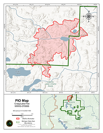
To ensure the safety of Craig Lake State Park visitors, and due to ongoing wildfire suppression operations on the Craig Lake Fire, the DNR has temporarily closed the park north of Craig Lake proper and the Teddy Lake Yurt through the end of October.
The North Country Trail within Craig Lake State Park has also been closed due to ongoing fire suppression operations.
The remainder of Craig Lake State Park is open to the public.
|
Black River Fire
In addition to its work on the Ridge and Craig Lake fires, the DNR took over management of the Black River Fire from the U.S. Forest Service Tuesday.
The 382-acre fire located 4 miles south of Wakefield, Michigan is currently 50% contained. It is burning in a densely forested area with difficult access.
“We’re grateful for the efforts of the U.S. Forest Service on the initial attack of the Black River Fire,” said Keith Murphy, DNR Incident Command. “We appreciate their continued assistance, along with that of the Minnesota DNR and Wisconsin DNR. It’s been a truly cooperative effort to achieve 50% containment of this fire.”
Agencies assisting the DNR on the Black River Fire include the Gogebic County Sheriff, Gogebic County Emergency Management, Wakefield Volunteer Fire Department, Bessemer Township Fire Department and U.S. Forest Service law enforcement.
The cause of this fire remains under investigation.
As always, the DNR reminds people to check Michigan.gov/BurnPermit before planning to burn yard debris or start a campfire, and to have an accessible water source nearby. For more fire safety tips, visit Michigan.gov/PreventWildfires.
Note to editors: Accompanying photos taken Tuesday are available below for download. Caption information follows. All photos courtesy of Michigan Department of Natural Resources.
-
Craig Lake Fire1: A Michigan Department of Natural Resources firefighter works to build a control line to provide access for firefighters and equipment.
-
Craig Lake Fire2: Smoke lingers in a remote area that recently burned in the Craig Lake Fire.
-
Craig Lake map: A map shows the wildfire perimeter (shown at the top, in red) and Craig Lake State Park boundaries (lower right, in green).
|