Buffalo Reef Task Force releases draft alternatives analysis
Report details analysis of three stamp sands disposal locations; public comments accepted through March 1
By JOHN PEPIN
Deputy public information officer
Michigan Department of Natural Resources
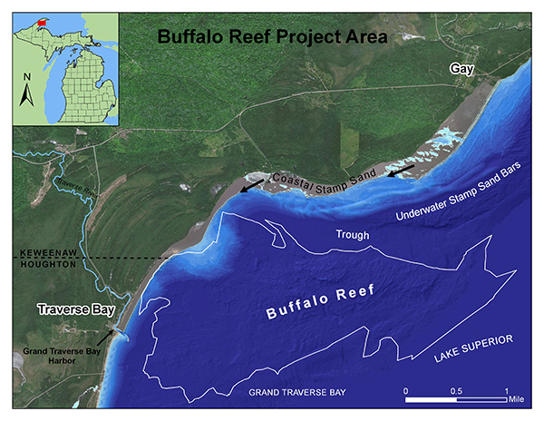
The multi-agency Buffalo Reef Task Force has issued its draft alternatives analysis for disposal of stamp sands removed from threatening valuable fish spawning and rearing habitat in and around the natural 2,200-acre reef, situated off the eastern coast of the Keweenaw Peninsula.
The task force decided on pursuing construction of an upland landfill for disposal of stamp sands removed from the Lake Superior shoreline as its preferred alternative course of action.
Future challenges facing the project include acquiring property and finding an agency committed to owning and maintaining associated project features, such as a jetty to stop stamp sand migration in Lake Superior.
The cost estimate for the project is $2.1 billion over the length of the project timeline.
Public comments are being accepted now through March 1 on the selected option and analysis of alternatives to protect Buffalo Reef in Michigan’s Keweenaw Peninsula.
The problem
Over the past roughly 100 years, historic copper mine tailings from the Wolverine and Mohawk mines – called stamp sands – were deposited at a milling site along Lake Superior, located in the community of Gay in Keweenaw County.
Since that time, the stamp sands have been moved by winds and waves south down the shoreline roughly five miles, inundating natural sand beach areas and threatening to cover spawning habitat and recruitment areas important to Lake Superior whitefish and lake trout associated with Buffalo Reef.
The important reef is located beneath the waters of Grand Traverse Bay.
Finalists
The three alternatives considered in the analysis include building an in-lake barricade around the original stamp sands pile to contain it, disposing of stamp sand in a nearby upland landfill or hauling the material to the mine tailings basins at the former White Pine Mine in Ontonagon County.
“The release of the draft Buffalo Reef Final Alternatives Analysis is the culmination of a couple years of gathering information and data to support the chosen alternative of creating a landfill for placement of the stamp sands,” said task force member Stephanie Swart, Lake Superior coordinator for the Michigan Department of Environment, Great Lakes and Energy. “The report contains analysis of the top three alternatives and discusses the formulation of the final alternatives and compares potential impacts.”
|
The alternatives analysis compares three scales of implementation of the landfill project.
“The scale of implementation differs based on the volume of stamp sands to be dredged and disposed of during the implementation phase,” Swart said. “Additionally, the study provides an assessment of the impact the volume of stamp sands removed during implementation has on the cost and duration of the operation, maintenance, repair, replacement and rehabilitation phase.”
Initial consideration
The release of the draft alternatives analysis follows a 2019 report that outlined 13 initially proposed alternatives to protect the reef.
Ten alternatives were eliminated in the effort to narrow down the best options, including novel ideas like placing dredged stamp sands in Keweenaw Peninsula mine shafts, building an artificial reef and moving the stamp sands out into deeper waters.
Three of the 13 were selected for further study, which became the final alternatives.
Jay Parent, district supervisor of the Michigan Department of Environment, Great Lakes, and Energy’s Water Resources Division in Marquette, said two of the three finalist alternatives were later eliminated.
“Placement of dredged material at the White Pine mine tailings basin involves high cost, no infrastructure at the former mine for freighter access and it’s not feasible to truck it there on existing roads,” Parent said.
The alternative to maintain dredging at Grand Traverse Harbor and trough with stamp sand placement behind a stone revetment surrounding the original deposit was also rejected.
|
“It is the lowest cost alternative,” Parent said. “But a significant negative is the material would remain on the lake bottom and the two-mile-long revetment would have to be maintained forever.”
Ongoing
Meanwhile, work continues by various partner agencies, including the Keweenaw Bay Indian Community, U.S. Army Corps of Engineers, EGLE and the Michigan Historic Preservation Office.
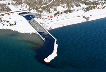
To help combat the threat posed to the reef and the harbor by the migrating stamp sands, various dredging efforts have taken place over the past few years, including removal of a 25-foot-high bank from the Lake Superior shoreline in 2019.
Harbor dredging efforts by the KBIC and others have worked to keep the waterway open for fishing, boating and other recreation.
The reef project, funded in part through the Great Lakes Restoration Initiative and an appropriation from the State of Michigan, is being executed in cooperation with the U.S. Army Corps of Engineers, U.S. Environmental Protection Agency, Keweenaw Bay Indian Community, the Great Lakes Indian Fish and Wildlife Commission, the Michigan Department of Natural Resources and the Michigan Department of Environment, Great Lakes and Energy.
All public comments received will be discussed and considered by the Buffalo Reef Task Force. Please direct comments to Stephanie Swart, Great Lakes Management Unit, Water Resources Division, at SwartS@Michigan.gov, or by U.S. Mail at EGLE, Water Resources Division, Great Lakes Management Unit, P.O. Box 30458, Lansing, MI 48909-7958.
To read the draft alternatives analysis, for more information on the ongoing effort to save Buffalo Reef, or to sign-up for the latest email updates, visit Michigan.gov/BuffaloReef.
|
Check out previous Showcasing the DNR stories in our archive at Michigan.gov/DNRStories. To subscribe to upcoming Showcasing articles, sign up for free email delivery at Michigan.gov/DNREmail.
Note to editors: Contact: John Pepin, Showcasing the DNR series editor, 906-226-1352. Accompanying photos are available below for download. Caption information follows. Credit Michigan Department of Natural Resources, unless otherwise noted.
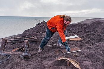
Dig: An archaeologist uncovers stamp mill workings along the Lake Superior shore outside Gay, Michigan. (Neal Harri photo)
Harbor: An aerial view shows Grand Traverse Bay and the harbor being dredged of stamps sands to keep commercial and recreational access open.
Map: A map shows the features associated with the Buffalo Reef issue.
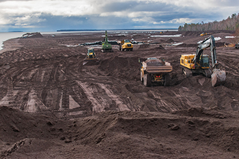
Removal: Crews work to remove deposited stamp sands from the Lake Superior shoreline near Gay, Michigan.
|