You get the picture – photo monitoring helps preserve Michigan’s natural areas
By HEATHER JOHNSON DUROCHER
Trails and resources writer and editor
Michigan Department of Natural Resources
Russ Ayers ticks off his list of must-have items: hiking boots and a vest with plenty of pockets to hold his compass, spare batteries, phone for photo-taking, sunglasses and bug spray.
He’ll also never leave home without his trusty backpack filled with water, snacks and at least one tall, kitchen trash bag for any invasive species he comes across.
Then there are the other essentials for a Michigan Department of Natural Resources stewardship photo monitoring volunteer: a tripod, target board and notebook, all of which are used to help capture changes to the natural landscape over time.
Oh, and don’t forget string or rope you’ll want to tie to many of these items, Ayers will remind you.
“Each of these things need to have a tether,” he said, “because if you drop something, it will be really difficult to find it.”
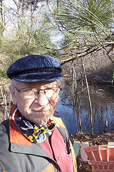
Ayers, who is in his early 80s, knows the stewardship volunteering drill well, having given hundreds of hours of his time to the DNR for nearly a decade – first with helping identify and remove patches of invasive species, like garlic mustard, in state parks and recreation areas, and later by assisting with the department’s photo monitoring efforts, which date back to the 1990s.
“It sounded interesting. I like taking photographs and I am a scientist at heart,” said Ayers, of Oak Park, who retired from a career working in an analytical laboratory.
Being a lifelong outdoorsman (and, well, knowing his doctor would like to see him exercise a tad more), Ayers jumped at the chance to be out in nature more often – sometimes off the beaten path and in some rather gnarly places (see tether comment above) – to do his part in helping the DNR protect, restore and manage the state’s valuable natural communities.
Just as important, he said, was doing something good for his mind.
“It turns out photo monitoring is interesting for a person who likes to solve puzzles,” he said.
Showing ‘tremendous progress’
|
Ray Fahlsing, stewardship unit manager with the DNR’s Parks and Recreation Division, said photo monitoring – capturing photos of a specific area over time – is a standard way to document ecological change.
“It’s a record of change that is happening on the landscape, and it informs changes to management so we can evaluate a treatment or a series of treatments,” said Fahlsing, who helped launch the department’s photo monitoring more than 25 years ago. “We can ascertain if we are going in the right direction and can adapt our management accordingly – it helps us understand management in the short term and also in the long term. It’s a good way to show the tremendous progress we’ve made.”
Technology advances in the past couple of decades have led to greater efficiency in capturing these images. Before smartphones, for example, a considerable amount of photography gear and time was required to capture and assess the imagery.
Between 60 and 70 locations, primarily in southern Michigan, are designated as photo monitoring sites, Fahlsing said.
“These photo points, we choose them very deliberately,” he said. “The DNR has a legislative mission to preserve the unique, natural parts of Michigan through a system of state parks.
“Each park preserves, conserves and restores the landscape and natural communities that are part of the natural heritage of that park or area. Each park has its own set of natural communities – these create a sense of place for the people who go there.”
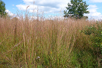
Photo monitoring may take place in an open dune, a forest, a Great Lakes marsh or another landscape.
“We want each of those different natural communities to have all their native species,” Fahlsing said. “We want to, as much as we can, restore the natural function of those systems, whether they’re providing a whole suite of ecosystem services, which might be aesthetics or recreation, or it may be pollinators, or it might be flood control.”
For Greg Norwood, an ecologist with the DNR’s stewardship unit, photo monitoring is an exciting tool because with the proper management approach, “the land can restore itself and bring species back from the brink.”
“Our state parks are one of the best opportunities (for restoration) because of the natural land we manage,” Norwood said. “We have one of the best opportunities to bring back some of the areas that have relic populations of plants and animals and are still natural … we are protecting species by managing their habitat and protecting lands.”
‘A picture is worth a thousand words’
|
Over time, the moments and changes captured through photo monitoring tell a story, Norwood said.
“A picture is worth a thousand words; that is what it is about,” he said of viewing how the state’s landscapes have evolved over time – and then determining how best to ensure these areas can be restored to their natural state.
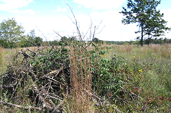
One example of critical work captured through photo monitoring: the removal of trees leading to prairie restoration.
“Every species has adapted to a specific condition, and our job is to make sure those conditions exist somewhere out there and exist within that range of natural variability that will preserve the most species,” he said.
“The reason we want to do this,” he said of removing certain trees as part of prairie restoration, “is we want the full complement of biodiversity and that includes areas that don’t have trees. We are protecting species by managing their habitat and protecting lands.”
Norwood added that photo monitoring is just one tool used by ecologists, who also monitor by assessing the specific plant species during and after restoration activities.
Significant photo monitoring captures
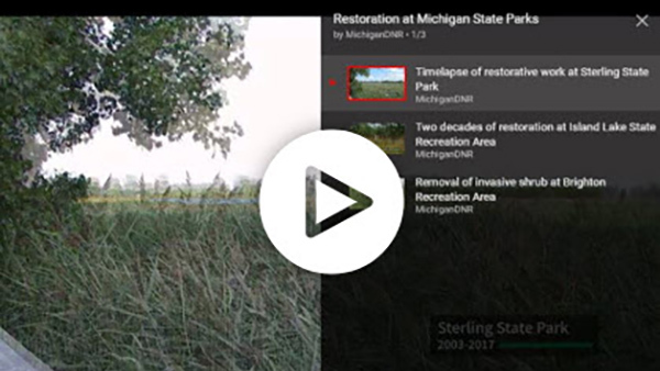
At Brighton Recreation Area in Livingston County, a photographic timelapse of more than 20 years reveals the restoration work in a prairie fen, a rare natural community throughout the world. The prairie fens at Brighton provide habitat for the threatened eastern massasauga rattlesnake.
Prairie fens are groundwater-fed wetlands dominated by grasses and sedges. Historically, natural fires helped keep them free of shrubs and trees. The DNR’s stewardship unit uses intentionally set prescribed fires to mimic the natural fire important to sustain prairie fens.
In this timelapse video at Brighton Recreation Area, you can see the positive impact of fire as it reduces shrub cover and promotes native plant species.
“Cycles of beaver flooding and drying interact with fire to reduce shrubs in prairie fens,” Norwood added. “In fact, this is actually happening at the Brighton Appleton fen with a pretty new beaver lodge there.”
At Island Lake Recreation Area, also in southeast Michigan, this video shows a timelapse of nearly 20 years of restoration work in an oak barrens, a unique natural community that is at risk of disappearing in Michigan.
|
Oak barrens are grasslands with widely scattered trees, in transition between prairie and dry oak-hickory forest. No high-quality oak barrens remain in Michigan, making restoration paramount.
To preserve and restore this system, the DNR uses a variety of management tools such as prescribed fire, removal of non-oak barrens species like pine trees and eradication of invasive plants that can outcompete native species.
If you see a burned area where a prescribed fire took place while you’re recreating in a state park, know it is part of ongoing stewardship of Michigan's valuable natural communities. Be sure to return in the future to see how the vegetation responds.
In the video’s last few images, you’ll see a resurgence of native grasses and wildflowers. This restored oak barrens now supports a rich diversity of insects and provides critical habitat for grassland-nesting birds.
And at William C. Sterling State Park – the only Michigan state park on Lake Erie – this timelapse shows the 400-acre Great Lakes marsh restoration that began in 2003.
The River Raisin empties into Lake Erie south of the city of Monroe, forming a 3,000-acre delta of marsh, lake plain prairie and lowland forest.
Rich in wild rice, fish and waterfowl, the delta sustained Indigenous people for millennia. But, since the arrival of Europeans in the 1700s, the delta has been filled, drained, dredged and diked.
Channels were dredged for boat passage. Marshland was pumped dry for farming. Ditches were dug to supply water to paper mills and other industries – and to carry away their effluent. Invasive phragmites invaded all Sterling’s degraded wetlands.
The Clean Michigan Initiative and the federal Great Lakes Restoration Initiative funded the restoration, and years of persistent treatment of invasive phragmites, prescribed burning, reconnecting marshes with Lake Erie and water control that mimics natural water fluctuations have had a spectacular result.
The role of volunteers
|
About 50 individuals have committed to helping with the photo monitoring project over the years, said volunteer coordinator Kelsey Dietz, a natural resource steward for the DNR.
It was volunteer Russ Ayers, in fact, who shared his photo monitoring expertise with Dietz when she joined the department about four years ago.
“He is so passionate about the work,” she said. “He has been absolutely invaluable to the photo monitoring project, and he’s always really excited about other volunteers joining the program.”
For Dietz, joining the DNR and being involved in photo monitoring gave her an even closer look at the special natural places here in Michigan.
“There are a lot of rare, unique ecosystems even in parks that are small and also in developed areas,” she said. “It’s important we survey these natural areas and know what features are there so we can protect them for future generations. And having that history of long-term change is valuable to our management efforts, and also for our morale as we work against invasive species – we can look back at all the progress being made.”
Ultimately, everyone benefits from the work that results from photo monitoring, Norwood said.
“There are ethical reasons for this work, and also our well-being as humans depends upon it,” he said. “Inherently, I think we want to pay attention.”
Photo monitoring volunteers are equally as passionate about protecting their public lands.
“They grew up in Michigan; they love visiting the parks,” Dietz said. “The extent of how many natural communities there are in these parks is just so mind-blowing. That connection is really vital, I think, to show just how valuable these parks are.”
Ayers’ love and appreciation for state parks and recreation areas – and the efforts to protect them – has only grown throughout his time as a DNR volunteer.
“The parks don’t just sit there – there are people who take care of them,” he said. “Sometimes what you see took an awful lot of work to maintain.”
“I get more out of it than the DNR does, seriously,” he added. “I get to have a lot of fun, a lot of wandering in the woods. It’s not something you can put a price on. The best part about it, when I go out on any kind of walk, I look for the little gifts that nature gives me – these little treasures I find out there.
“As I tell my grandson, ‘If you’re quiet and observant, nature is always going to give you a gift – are you going to recognize it when she does? Because sometimes it’s something big.’”
Interested in volunteering with the DNR’s stewardship efforts? Contact Kelsey Dietz at 517-388-8517 or DietzK2@Michigan.gov.
|
Check out previous Showcasing the DNR stories in our archive at Michigan.gov/DNRStories. To subscribe to upcoming Showcasing articles, sign up for free email delivery at Michigan.gov/DNREmail.
Note to editors: Contact: John Pepin, Showcasing the DNR series editor, 906-226-1352. Accompanying photos and a text-only version of this story are available below for download. Caption information follows. Credit Michigan Department of Natural Resources, unless otherwise noted.
Text-only version of this story.
Ayers: Russ Ayers, pictured here, has given hundreds of hours of his time volunteering for the Department of Natural Resources for nearly a decade – first with helping identify and remove patches of invasive species in state parks and recreation areas, and later by assisting with the department’s photo monitoring efforts.
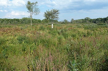
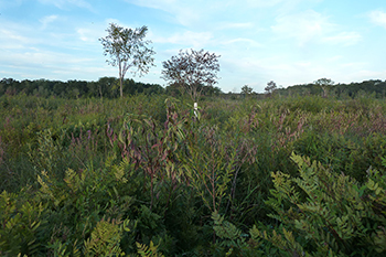
Highland1_2012 and Highland1_2014: These images, taken at the same spot at Highland Recreation Area in Oakland County years apart, captures the landscape in 2012 and 2014.
Highland2_2008, Highland2_2013 and Highland 2_2021: These images, taken at the same spot at Highland Recreation Area, captures the landscape in 2008, 2013 and 2021.
|