|
June 27, 2022
Contact: Jay Parent (EGLE), 906-236-9611
Buffalo Reef Task Force to reveal plan for stamp sands at July 12 public meeting in Houghton County
After more than three years of work to develop a plan to dispose of stamp sands mining waste threatening the lake trout spawning habitat of Buffalo Reef, a multiagency task force is set to provide details to the public.
A public meeting has been set for 6 p.m. Tuesday, July 12, at the Lake Linden-Hubbell High School auditorium, 601 Calumet St. in Lake Linden.
During the meeting, representatives from the Buffalo Reef Task Force will discuss the preferred plan, selected from an initial list crafted in 2019 of 13 potential strategies proposed for managing the stamp sands.
“Though our plan has been selected, we still need to identify a nonfederal sponsor and funding source(s) before we can move ahead with implementing our strategy,” said Jay Parent, district supervisor for the Michigan Department of Great Lakes, Environment, and Energy’s Upper Peninsula District Office in Marquette. “The scope of our plan may also change as the project matures.”
|
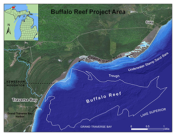
Over the past roughly 100 years, historic copper mine tailings from the Wolverine and Mohawk mines – called stamp sands – were deposited at a milling site along Lake Superior, located in the community of Gay in Keweenaw County.
Since that time, the stamp sands have been moved by winds and waves south down the shoreline roughly 5 miles, inundating natural sand beach areas and threatening to cover spawning habitat and recruitment areas important to Lake Superior whitefish and lake trout in and around Buffalo Reef.
The Great Lakes Indian Fish and Wildlife Commission has determined that Buffalo Reef, which is situated off the Keweenaw Peninsula’s Grand Traverse Harbor, contributes approximately 30% of the lake trout harvested within 50 miles of the reef.
The three finalist action plans include:
- Building a retaining wall to contain the stamp sands at the original pile, as well as the stamp sands dredged from the lake and beach.
- Building a landfill in an upland area near the community of Gay for the stamp sands removed from the lake and beach.
- Placement of stamp sands removed from the lake and beach in the tailing basins at the former White Pine Mine in Ontonagon County.
Over a period of several months, a team of engineers and scientists worked to develop preliminary implementation cost estimates and to identify potential benefits and risks for each alternative.
The alternatives were narrowed down with the help of input from the public and experts from numerous fields. Next steps in the process include finding the required funding and sponsor, then designing and implementing the preferred plan.
Benchmarks
In February 2019, the task force issued an alternatives analysis which briefly described 13 potential strategies for managing the stamp sands.
After that, the task force sought public comment on whether there were additional management strategies the group should consider and whether any adjustments should be made to the management strategies or risks described in the draft analysis.
In May 2019, the task force released a responsiveness summary to public comments on the analysis of the alternatives.
A month later, the task force met to review the 13 alternatives and hone the finalists down to the three options, to then be fleshed out with specific costs and feasibility.
The project to save the 2,200-acre reef – which is being funded through the Great Lakes Restoration Initiative and a combination of state and tribal funds – is being executed in cooperation between the U.S. Army Corps of Engineers, the U.S. Environmental Protection Agency, the Keweenaw Bay Indian Community, the Great Lakes Indian Fish and Wildlife Commission, the Michigan Department of Natural Resources and the Michigan Department of Environment, Great Lakes, and Energy.
For more information on the ongoing Buffalo Reef effort or to sign up for email updates, visit Michigan.gov/BuffaloReef.
|