Fish habitat improved with dam removal project on Dowagiac River in Berrien County
By BRIAN GUNDERMAN
Michigan Department of Natural Resources
In the southwest corner of Michigan, the Dowagiac River, one of the largest cold-water streams in the region, flows into the mighty St. Joseph River, near the City of Niles.
Annual stocking by the Michigan Department of Natural Resources there supports a popular brown trout fishery.
In addition, the construction of fish ladders at the Berrien Springs and Buchanan dams on the St. Joseph River have allowed steelhead (rainbow trout that spend part of their lives in the Great Lakes), Chinook salmon and coho salmon to move into the lower Dowagiac since the early 1990s.
The impassable Pucker Street Dam has confined these migratory fish species to the lower 3 miles of the Dowagiac – until now. Fish are about to have a lot more territory to explore thanks to an ongoing project to remove the dam in Berrien County.
Site preparation and powerhouse removal at the Pucker Street Dam started in fall 2019. The removal of the actual dam structure began in spring 2020. When the removal is completed this summer, steelhead and salmon will have access to an additional 159 miles in the Dowagiac River and its tributary streams.
In addition, fragmented populations of native fish species occurring upstream and downstream of the dam, such as smallmouth bass and suckers, will be reconnected. The dam removal also will restore approximately 1.2 miles of high slope stream habitat in the former reservoir, exposing more gravel bottom for fish spawning and invertebrate (i.e., fish food) production.
Beginnings
To truly appreciate the significance and challenges associated with this dam removal project, it’s important to know a little bit about the dam’s history.
|
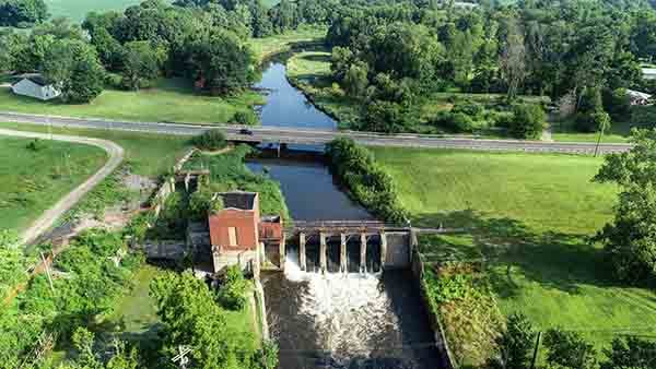
The steep rapids on the Dowagiac River, near the existing Pucker Street bridge, have been a magnet for people looking to harness the river’s power for industrial purposes.
In 1828, a wooden dam was constructed at this location to power a mill. The “modern” concrete dam was built a short distance downstream of the wooden dam in 1928 to generate electricity for the City of Niles.
The reservoir behind the dam filled with sediment, was dredged and then filled again until the dam became less profitable to operate. Electrical generation ceased in 1995.
In 1999, the city decided to permanently drop the water elevation in the reservoir by 5 feet to reduce stress on the aging dam. The amount of sand that moved downstream as a result of the 1999 drawdown exceeded expectations.
The DNR installed a sediment trap on the upstream side of the dam to remove some of this sand. Subsequent monitoring conducted at seven sites downstream of the dam indicated that the river was able to evacuate most of the sand by July 2000.
Since 1999, the city, the DNR and other partners have had numerous conversations about the future of the Pucker Street Dam. In 2013, the city concluded that rehabilitating the dam to produce electricity was not likely to be economically viable and began the dam removal planning process.
|
Removing a structure as large as the Pucker Street Dam is a major undertaking, so a diverse team was assembled to help coordinate the project and find funding sources.
Funding for the dam removal has come from a variety of sources, including the City of Niles, the U.S. Fish and Wildlife Service, the DNR Aquatic Habitat Grant and Dam Management Grant programs, the National Fish and Wildlife Foundation and the Great Lakes Fishery Trust.
The estimated price tag for the dam removal totals about $12 million.
Sediment removal
One of the key issues that the dam removal team has had to address is managing the huge volume of sediment that has accumulated behind the dam over its long history.
Several measures have been incorporated into the removal design to reduce and monitor downstream movement of the sediment. A sediment trap was excavated between the dam and the Pucker Street bridge before any drawdowns of water occurred.
The lowering of the water level behind the dam has been accomplished through multiple small drawdowns rather than one large event. The sediments behind the dam also are being excavated to create a new pilot channel for the stream through the former reservoir.
Suzannah Deneau with Wightman & Associates, Inc. is the lead engineer in charge of the dam removal project.
|
“We are fortunate that land neighboring the dam site became available for sale during the project, allowing us to remove approximately 50% of the excavated sediment from the river valley, reducing mitigation costs and increasing the opportunity for wetlands to reform,” Deneau said.
The excavation work began at the upper end of the impoundment and is nearly complete.
The pilot channel is anticipated to transform into a more natural and diverse segment of the stream as the water’s power and the deposition of large pieces of wood shape the river’s form.
Monitoring the downstream sediment movement has consisted of multiple tiers.
The team from Wightman & Associates works with city staff to measure the amount of sediment suspended in the water upstream and downstream of the project area.
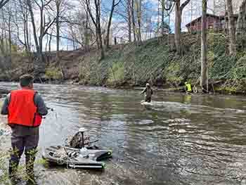
To detect sediment movement along the stream bed, the DNR and staffers from the Pokagon Band of Potawatomi Department of Natural Resources routinely measure stream bed elevations at two transects downstream of the dam near Losensky Park.
The city also periodically conducts drone flights over the project area to check for stream bank failures. Stream experts from Inter-Fluve use the drone footage and on-site inspections to formulate recommendations on stream channel adjustments and techniques for restoring native streambank vegetation.
Volunteers conduct additional visual monitoring of sediment deposition in the lower Dowagiac River.
Long-term gains
With every dam removal project, there is a tradeoff of a short-term disruption to the river system in exchange for long-term ecological and recreational benefits.
|
In the case of the Pucker Street Dam, the steelhead and salmon runs attract many anglers to Losensky Park each spring and fall. In September-November 2020, as the project work continued, the City of Niles and their contractors were able to install fencing and keep a portion of the park open to anglers.
While the work progressed and more of the excavation began occurring in the proximity of the park, human safety and liability concerns made it necessary to close the park in December 2020.
If all goes as planned, the dam removal will be complete, and the park will be reopened with a temporary drift boat/canoe launch, for the fall 2021 salmon and steelhead runs.
While reopening of Losensky Park for shore fishing and drift boat access will be an important milestone, there also are new options opening up for anglers this year.
“The ability of steelhead and salmon to move past the former dam location is changing the distribution of fishing effort on the river,” said Matt Diana, the DNR Fisheries Biologist that covers the Dowagiac River. “This spring we had reports of steelhead as far upstream as Lake of the Woods in Decatur. Fish also can move up Dowagiac Creek (a tributary of the Dowagiac River) to the city of Dowagiac.”
One of the objectives of the DNR is to work with local partners to enhance public access and recreational opportunities on the Dowagiac River system.
|
Anglers already can access the river at the DNR boating access site off Peavine Street, and Arthur Dodd Memorial County Park is a good site for shore fishing. The park also has a canoe/kayak launch. However, local fishing guides have reported that large numbers of log jams are hindering boat passage between Peavine Street and the Pucker Street Dam project area.
The Southwest Michigan Planning Commission and the Cass County Parks Department are working to secure grant funding from the Gateway Foundation to hire contractors to selectively remove portions of log jams beginning in July.
In addition, the City of Niles recently purchased 45 acres adjacent to Losensky Park. This land initially is serving as one of the areas for depositing sediment excavated from the Pucker Street Dam reservoir. The long-term vision is to develop this property for outdoor recreation and install a permanent boat ramp at Losensky Park.
“In the long term, this project will yield big dividends for anglers,” Diana said. “By creating access to new spawning areas, the Pucker Street Dam removal will lead to increased numbers of steelhead and salmon in the Dowagiac and St. Joseph rivers and contribute to the open-water fishery in Lake Michigan.”
Jeff Dunlap is the utilities manager for the City of Niles and has been involved with the project since its inception.
“Removing the Pucker Street Dam will eliminate ongoing liability and maintenance costs for the city,” Dunlap said. “The DNR has been a fundamental partner in this project over the last several decades. The guidance and feedback provided by DNR staff has allowed the project to develop from concept to completion.”
Anglers wanting to learn more about the project should check out the City of Niles website, which has project updates, photos and videos, and also includes an option for people to sign up to receive project status reports via text or email.
The revitalization of the Dowagiac River system in this part of Michigan has been decades in the making. The fruits of that effort are now beginning to ripen.
|
Check out previous Showcasing the DNR stories in our archive at Michigan.gov/DNRStories. To subscribe to upcoming Showcasing articles, sign up for free email delivery at Michigan.gov/DNR.
/Note to editors: Contact: John Pepin, Showcasing the DNR series editor, 906-226-1352. Accompanying photos and a text-only version of this story are available below for download. Caption information follows. Credit Michigan Department of Natural Resources, unless otherwise noted.
Text-only version - Showcasing - Pucker Street Dam Removal
Photo 1: Pucker Street Dam prior to the beginning of the dam removal project. Photo by Jeff Dunlap, City of Niles.
Photo 2: Pucker Street Dam in October 2019 after removal of the powerhouse.
Photo 3: Matt Diana, Michigan Department of Natural Resources fisheries biologist, is shown standing next to gates removed from the Pucker Street Dam in early June 2020.
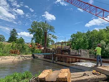
Photo 4: Milbocker & Sons, Inc. workers installing sheet pile to prepare for dam removal in June 2020.
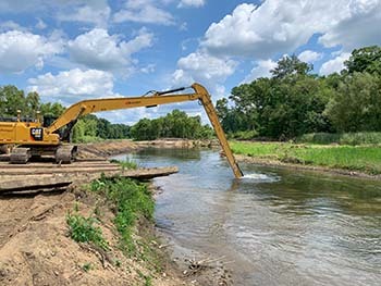
Photo 5: Milbocker & Sons, Inc. workers excavating the pilot channel through the Pucker Street Dam reservoir in August 2020.
Photo 6 and 7: Remnants of original 1828 dam are shown that were exposed during drawdown o f the reservoir behind the Pucker Street Dam in late June 2020.
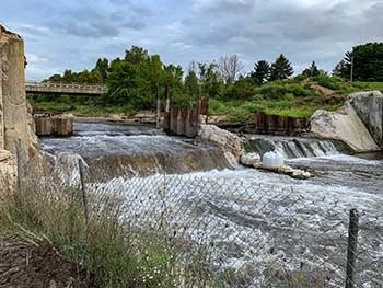
Photo 8: Pucker Street Dam in September 2020 after partial removal.
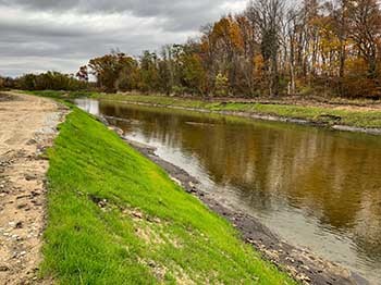
Photo 9: Site of the former Pucker Street Dam shown in April. A naturalized river rapids will be constructed at this location in late May-June.
Photo 10: Reinforcement of Pucker Street Bridge piers is shown after partial drawdown of the reservoir in December 2020. Note the steep banks in the background that show the extent of the decline in water elevation.
Photo 11: Recently excavated stream banks immediately upstream (north) of the Pucker Street bridge.
Photo 12: Revegetation of stream banks along the pilot channel, upstream of the Pucker Street Dam in October 2020.
Photo 13: Grant Poole, left, from Pokagon Band of Potawatomi Natural Resources Department prepares a small boat with sonar and GPS equipment while Brian Gunderman, center, and Matt Diana, both from the Michigan Department of Natural Resources, string a rope to allow the boat to move across one of the sediment monitoring transects downstream of the Pucker Street Dam. Photo by Suzannah Deneau, Whiteman & Associates, Inc.
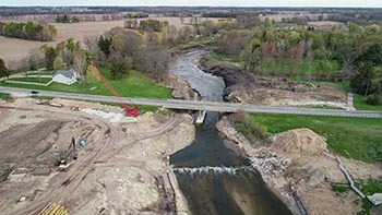
Photo 14: Site of the former Pucker Street Dam in early May 2021. Photo by Jeff Dunlap, City of Niles./
|