The multi-agency Buffalo Reef Task Force is looking for help from shoreline property owners in reporting flooding and ice shove events along Grand Traverse Bay.
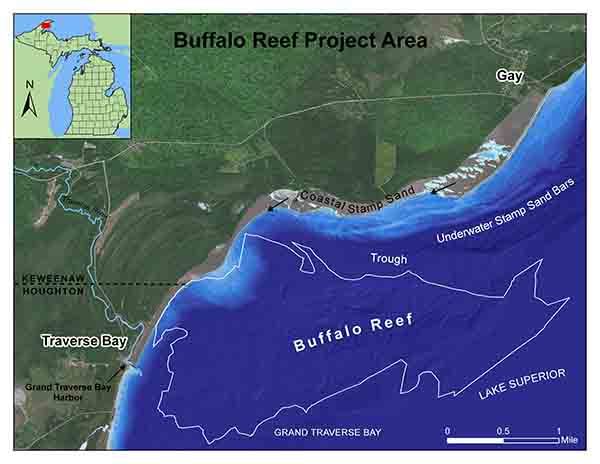
Over the past roughly 100 years, historic copper mine tailings from the Wolverine and Mohawk mines – called stamp sands – were deposited at a milling site along Lake Superior, located in the community of Gay in Keweenaw County.
Since that time, the stamp sands have been moved by winds and waves south down the shoreline roughly 5 miles, inundating natural sand beach areas and threatening to cover spawning habitat and recruitment areas important to Lake Superior whitefish and lake trout in and around Buffalo Reef.
The natural reef is situated beneath the waters of Grand Traverse Bay.
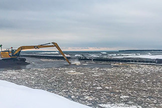
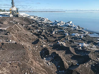
To help combat the threat posed to the reef and the harbor by the migrating stamp sands, various dredging efforts have taken place over the past couple of years.
“The U.S. Corps of Engineers is developing a dredging plan to protect Buffalo Reef and associated juvenile fish habitat,” said task force member Stephanie Swart, Lake Superior coordinator for the Michigan Department of Environment, Great Lakes and Energy. “The plan must also protect shoreline property owners from flooding and ice shove.”
Property owners located between the community of Gay and Grand Traverse Point, including those situated south of the harbor, are asked to fill out a brief reporting form.
“Pictures are helpful, but dates and locations of flooding or ice shove will help the design team minimize future occurrence of these incidents,” Swart said.
Meanwhile, efforts to decrease the amount of stamp sands along the beach have been ongoing over the past few months.
From Nov. 14 through Dec. 6, 2019, 175,000 cubic yards of stamp sands were removed from the original milling site at Gay. This work included pulling a 25-foot-high bank of deposited sands back from the Lake Superior shoreline.
In addition, 13,255 cubic yards of stamp sands were removed from the Grand Traverse Harbor and another 32,677 cubic yards of material was moved from the adjacent beach in work that began Jan. 2 and ended Jan. 28.
“The removal of stamp sands north of the breakwater provides some protection for the harbor, but is not a permanent solution,” Swart said. “With record high water levels expected for 2020, waves will continue to form a ridge of stamp sand along the shoreline that overtops the north jetty at Grand Traverse Harbor.”
For the short term, this ridge of stamp sands will have to be removed periodically.
The task force is continuing its work to develop a long-term solution that protects juvenile whitefish habitat south of the harbor, while keeping the harbor open for fishing, boating and other recreation.
The trough area, which is located directly north of the reef, will be dredged this spring. This winter’s dredging activities will enable to the contractor to work in the trough once ice leaves the bay.
|