|
Share or view as a webpage | Update preferences
2022 Maps and Data Highlights
In 2022, EGLE developed eight new interactive web maps and dashboards, five new story maps, 21 new open data items, and one new hub site, for a grand total of 35 new features shared on the Michigan Department of Environment, Great Lakes, and Energy (EGLE)'s Maps and Data Portal, the central location for maps and data.
The new features -- ranging from test results in high profile pollution events to where grants and loans are going -- are part of EGLE's commitment to transparency and accessibility. The agency continues to work to make information and data available quickly on the EGLE website.
EGLE’s Most Popular Maps & Data Items
These items include some of our most public popular content of the year. Here are the top three featured items in each category:
Featured New Web Maps and Dashboards
1. Michigan Water Infrastructure Funding and Financing Dashboard
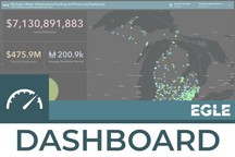
Published in September 2022, this dashboard is meant for general information about current and historical projects funded through the Clean Water State Revolving Fund and Drinking Water State Revolving Fund. It is continually updated with new projects as they come in. This is also by far the most viewed geospatial item that EGLE published in 2022.
|
2. Tribar Release Sampling Results
Published in August 2022 and following a release of hexavalent chromium to the Wixom Sewage Treatment Facility from Tribar Manufacturing in Wixom, MI, this map displays the results from EGLE's monitoring results.
3. MiEJScreen Web App-Executive Summary Draft
Published in March 2022, MiEJScreen is an interactive mapping tool that identifies Michigan communities that may be disproportionately impacted by environmental hazards. The map allows users to explore the environmental, health, and socioeconomic conditions within a specific community, region, or across the entire state. These data sets can be viewed individually or combined into a final MiEJScreen score that allows users to understand how communities experience environmental justice impacts relative to others.
Featured New Story Maps
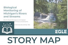
1. Biological Monitoring of Michigan’s Rivers and Streams
Published in February 2022, story map, first published in February 2022, details where biological monitoring has occurred in Michigan, including links to the most recent biological survey reports and contact information for the appropriate EGLE bio logical survey staff person. This story map received the “Analytic Presentation Honorable Mention” award at the 2022 IMAGIN GIS conference! |
|
 |
2. Bioengineered Shoreline Protection on Inland Lakes
Published in May 2022, this story map details what bioengineering and includes examples from many successful projects in the state. Bioengineering is a flexible method of shoreline protection that is used to stabilize inland lake shorelines to prevent erosion while protecting and enhancing fish and wildlife habitat on Michigan's inland lakes. Bioengineering uses a combination of native plantings and natural or biodegradable materials to engineer shoreline protection that, to the extent possible, mimics and or enhances the natural landscape.
3. How Landfills Work
Published in December 2022, this story map details how landfills work, specific to the State of Michigan, and includes information on disposal regulations, landfill term definitions and glossary, and what a day at a landfill is like.
Featured New Open Data
1. Underground Storage Tanks
Published in May 2022, this data includes the locations of underground storage tanks that are either licensed by the Michigan Department of Licensing and Regulatory Affairs (LARA) and/or are leaking underground storage tanks that are regulated by the Michigan Department of Environment, Great Lakes, and Energy (EGLE). Many businesses utilize underground storage tanks for products such as gasoline, diesel fuel, and other liquid chemicals. Environmental damages and safety risks can result from improper installation and maintenance as well as degradation of the tanks over time.
|
2. Wellhead Protection Areas (WHPA)
Published in August 2022, EGLE’s source water protection program includes identification of areas where groundwater is used to supply drinking water to communities. A Wellhead Protection Area (WHPA) is the surface and subsurface area surrounding a water well or well field, supplying a public water system, through which contaminants are reasonably likely to move toward and reach such water well or well field. It is that area which contributes groundwater to a public water supply well.
3. Fuel Transformation Program Grants
Published in August 2022, the Fuel Transformation Program (FTP) provides grant funding for the replacement of qualifying diesel vehicles, vessels, and equipment with new, cleaner versions that have low to no emissions. Grants to support this transition are made available through Michigan's $64.8 million allocation of Volkswagen settlement funds. This data shows the completed and in-progress grants. This data is featured in our Fuel Transformation Program Dashboard.
Other Highlights from 2022
Upcoming Events
-
March EnviroSchool: What Makes EGLE Spatial? How to ask and answer environmental questions with EGLE’s Maps and Data Portal: Geographic data helps tell a story and create intelligence about the world around us. Join EGLE’s Lead Geographic Information Systems (GIS) Analyst to discover how EGLE develops innovative geospatial solutions that analyze and visualize data to inform decisions, streamline workflows, increase productivity, and tell our story in every EGLE division. Learn how you can access Michigan data from EGLE’s Maps and Data portal that will bring environmental issues to life for your students, and how your students can collect, visualize, and analyze data of their own! Part of the EGLE Classroom Educator Series.
-
MI Statewide GIS Users Meetings: The Statewide GIS User Group provides quarterly networking and educational opportunities for GIS professionals across Michigan. The meetings are open to everyone from students through seasoned professionals and feature a range of technical and non-technical topics. See link above for meeting information and below for the 2023 dates.
- Thursday, May 4, 2023
- Thursday, August 3, 2023
- Thursday, November 2, 2023
- Upcoming Local Conferences:
Questions? Concerns?
Send an email to EGLE-Maps@Michigan.gov.
Visit our Open Data Portal for more information.
|