
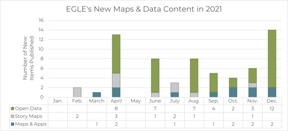
2021 Maps and Data Highlights
Michigan Department of Environment, Great Lakes, and Energy sent this bulletin at 01/10/2022 02:30 PM EST
2. Primary Sulfur Dioxide National Ambient Air Quality Standard Nonattainment Areas – 2010 Published in April 2021, this data outlines the statewide nonattainment areas (areas considered to have air quality worse than the national standards) for the 2010 Primary Sulfur Dioxide NAAQS as designated by the USEPA. This data is used in the Air Monitoring Sites web map. Published in September 2021, this data outlines the layer boundaries of EGLE's districts. This data is used in the EGLE District Boundaries and Office Locations web app. Upcoming eventsMI Statewide GIS Users Meetings: The Statewide GIS User Group provides quarterly networking and educational opportunities for GIS professionals across Michigan. The meetings are open to everyone from students through seasoned professionals and feature a range of technical and non-technical topics. See link above for meeting information and below for the 2022 dates.
Questions? Concerns?Send an email to EGLE-Maps@Michigan.gov. Visit our Open Data Portal for more information.
| |


If you wish to no longer receive emails from us,
please update your preferences here:
Manage Preferences | Help
Need further assistance?
Contact Us | Provide Feedback