Friendship and Monhegan Bedrock Maps Released
The Maine Geological Survey (MGS) is pleased to announce the release of a pair of bedrock geologic maps in the mid-coast area, the Bedrock Geology of the Friendship Quadrangle, Maine, and the Bedrock Geology of the Monhegan Quadrangle, Maine. Together they extend from the Friendship and Cushing mainland southward across the islands in Friendship Harbor and the Georges Islands, out to Monhegan. The maps show the complex distribution of Cambrian, Ordovician, and Silurian stratified rocks in three stratigraphic sequences affected by multiple episodes of metamorphism and deformation and intruded by a variety of Silurian-Devonian igneous rocks.
The map sheets include detailed descriptions of over 30 map units, age results from rock analyses, an abundance of field photographs, interpretive cross sections, and extensive narrative description of the geologic history and plate tectonic evolution that led to the existing distribution of rock units. These maps, compiled by J. Dykstra Eusden, professor emeritus of Bates College, and Henry N. Berry IV of the Maine Geological Survey, are part of the ongoing mapping program of the MGS, supported in part by collaborative grants from the National Geologic Mapping Program of the U.S. Geological Survey.
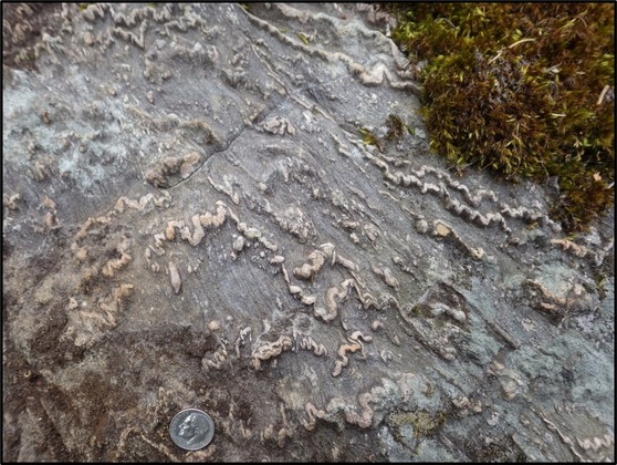
Megunticook Formation in the Friendship quadrangle. It is a fine-grained sandstone of probable Cambrian age metamorphosed to quartzite. The thin pink layers of quartz and garnet (coticule) are a distinctive feature of the formation.
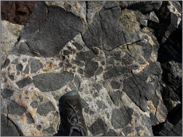
Light colored igneous rock (granodiorite) containing abundant angular fragments of dark colored igneous rock (gabbro), from the Monhegan quadrangle.
|