Maine Sea Level Rise Ticker and Dashboard Released

Having trouble viewing this email? View it as a Web page. Bookmark and Share

News and Information

Maine Sea Level Rise Tracking Products Released

flooded road

Are you interested in the most recent information on flooding and sea level rise in Maine? If so, visit the newly released Maine Geological Survey Maine Sea Level Rise Ticker and Maine Sea Level Rise Dashboard. Just like a stock market ticker tracking the rise and fall of share prices, these interactive viewers, updated every month, provide the public with the best available information on past and future ocean and tide levels.


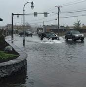
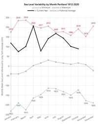
The Ticker provides short-term (1995-present) sea level rise rates and monthly water level rankings for each of Maine’s five tide gauges from Wells to Eastport in a simple interface. For each tide gauge, the Dashboard provides in-depth data and visual summaries on short- and long-term sea level rise. In addition, you can find recent monthly trends. The Dashboard shows information on nuisance and storm flooding, and how sea level rise scenarios might make nuisance flooding more common in 2030 and 2050. 

graph

Maine Geological Survey

207-287-2801 

mgs@maine.gov 

www.maine.gov/dacf/mgs